Hottest Time Of The Year? In Theory Anyway
We are right smack dab in the middle of the hottest time of the year. Well, climatologically, anyway. Today is the very peak of our hottest average temperatures, when nights are warmest and days are hottest. Starting tomorrow...gasp....we start the downward cycle into cooler times (again, so far as averages go but not necessarily on a daily basis). I shudder to think about the fact that we've already lost 31 minutes and 30 seconds of daylight since the solstice (not that I'm counting). Lovers of the summer swelter may feel their anxiety build a bit more over the next few days, but fear not - we're not done with the heat yet.
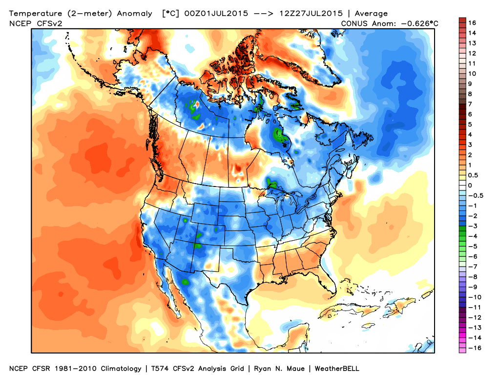
Temperature departures for the month of July to date. Been an extremely cool month for the Great Lakes and Midwest, without much harsh heat for the east either. Source: Weatherbell
So what are those averages anyway? In Boston, it's a high of 83 and a low of 66 this time of year. In Worcester, it's a high of 80 and a low of 62. We're not that far off the mark today with upper 70s to around 80, but no one would make the case that it's been a rough summer so far. June was well below average and July will likely end up a touch below average as well. We've picked up a couple 90 degree days, but on the whole the Midwest to the Northeast has had a very comfortable run to this point.
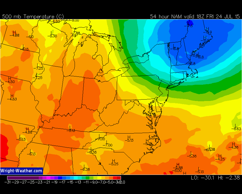
Forecast temperatures at 500mb on Friday afternoon. This deep pool of cold air helps destabilize the atmosphere, promoting clouds and downpours once the sun warms up the lower levels. It also brings down the freezing level, helping to increase the chances for hail. Source: Wright-Weather.com
Looking forward, the coolest air will be around on Friday and Saturday. Very chilly air aloft will swing down from northern New England on Friday, helping to produce instability and scattered downpours. Whenever one of these downpours pop up, they'll drag down some of that cooler air and would quickly drop the towns they visit into the 60s. They'll also likely produce some gusty winds and hail as the freezing level will be quite low. Fairly dry air will be in place near the surface, which helps produce gusty downpours as rain evaporates into the air (and also, in turn, cools the air more). I'm thinking highs will generally max out in the mid 70s, with a few upper 70s to the south.

Saturday's cool temps are expected to be a product of an onshore flow as a backdoor cool front ushers in the east wind. That should hold us in the 70s, and possibly even upper 60s along the immediate North Shore coastline and Cape Ann. The farther west you go, the warmer it will get with a shot at 80 toward western Mass. The sky cover forecast is a little trickier. Models have been hinting at a decent amount of low level moisture, which could keep persistent clouds east of the Worcester hills. We'll update that outlook as we get a little closer, but in any case it doesn't look like a hot July day.
The next disturbance in the hopper will come through on Sunday. The exact timing will determine whether we see some stronger storms and how warm the day will manage to become. But it should at the very least swing our winds around to the south instead of from the east, allowing milder air to flow in.
Depending on exact timing, Sunday looks like another day of below average temps. If an approaching cold front gets here quickly and with lots of debris clouds from previous storms, it could hold us in the 70s. If we manage a little more sun before sct'd showers and storms develop, then we could hop up into the 80s. We're still early in the game regarding this one so this too will get updated as we get a little closer. Currently leaning toward the cooler side, in the 76-82 range for highs.
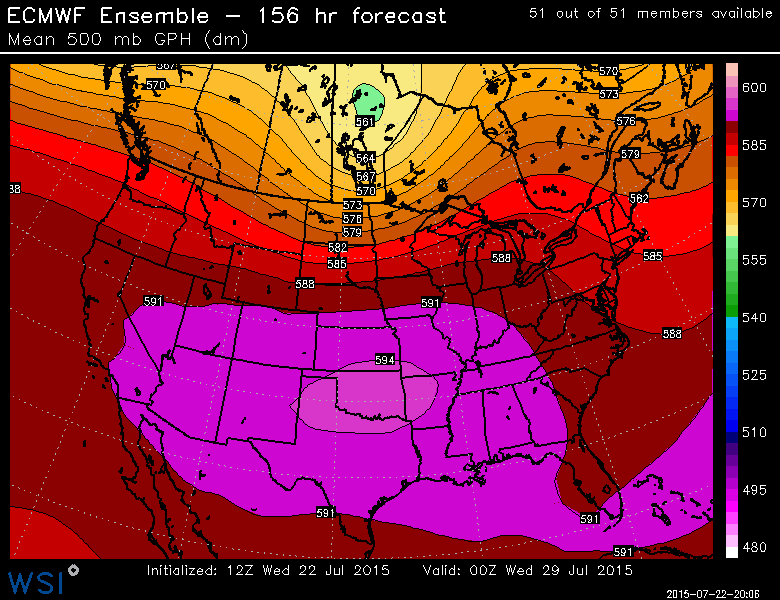
ECMWF Ensemble at 500mb shows a strong ridge over the middle of the country with weaker, yet significant enough, ridging building into the Northeast for Tuesday and Wednesday. Source: WSI Energycast
But after all this cool talk, there is some hope for those in search of heat. Indications are for a building ridge over the east and the return to a warm & muggy flow of air for at least a couple of days. Tuesday should get well into the 80s, with perhaps some 90s back in action by Wednesday. The classic, long stretch of HHH weather doesn't look like a strong bet though. Last year we didn't have a single heat wave in Boston - perhaps it's a feat we'll manage again this year?
The other thing to note on that above image is the troughing nosing down along the SE Atlantic coast. The setup is conducive for some possible tropical development later next week, and it's something we'll have to monitor here in New England. Certainly it's no slam dunk, but this is the type of tropical system we'd expect this year. There's a ton of shear, dust, and cool water temps over the MDR (main development region) of the Atlantic. Chances are low for a busy Cape Verde season. So what we're more likely to see are home-grown tropical systems that develop close in to land. And with an extremely warm Gulf Stream right now, anything that manages to organize could intensify rather quickly. Stay tuned!