Beyond The Forecast: The Quest for 70 Degrees
BOSTON (CBS) – There's nothing particularly notable about 70 degrees. Plants don't freeze, pipes don't burst, heat exhaustion isn't an issue, and eggs don't cook on sidewalks. It's just a nice round number indicating a nice comfortable air mass. A point at which you can go outside without a jacket, but at the same time aren't sweating bullets.
Check: Weather Blog | Current Conditions | Share Photos
When it goes away for the final time in a year it marks the end of summer, and when it shows up the following year it's time to start thinking about sandy beaches and margaritas once again. Some may even argue it's the 'perfect temperature' although that's a notion some will fight with you about until they're blue in the face.
Finally, after many months, we're about to experience it again. Now there are some lucky ducks reading this blog who have already seen their town pop into the 70s this year. Back in mid-April inland towns managed to warm to this blissful state of spring glory. But the city of Boston and most coastal communities are still waiting for their turn. A wait that is approaching record territory, but finally this is a record we will not manage to fell!
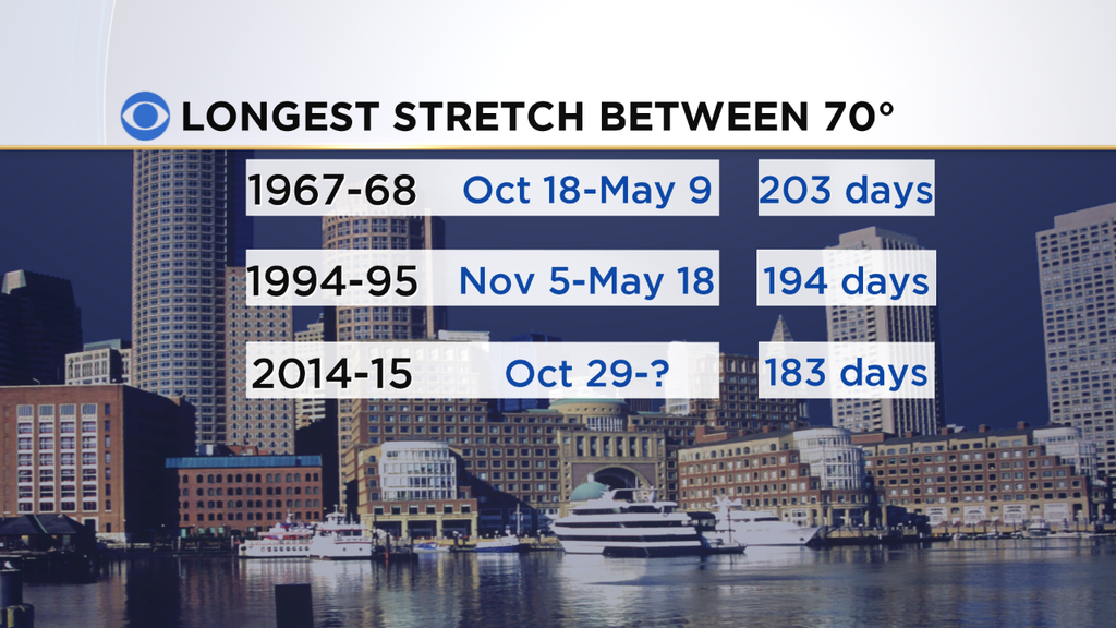
I rummaged through the old weather records and found that there have only been a pair of times in which we had a longer stretch between 70 degree readings. One was back in the 60s, the other in the mid 90s.
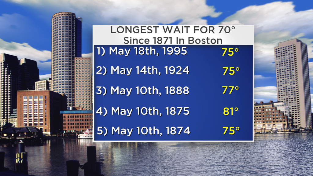
There were some long waits back in the 1800s too, but those records are a little wonky because the old weather observation site in Boston used to be a couple hundred feet up on top of a building in the Financial District.
It moved in 1936, and so I'm used that year as a 'starting point.' 1995 was particularly painful with the longest wait into spring ever recorded (1800s included!) - all the way until May 18th.
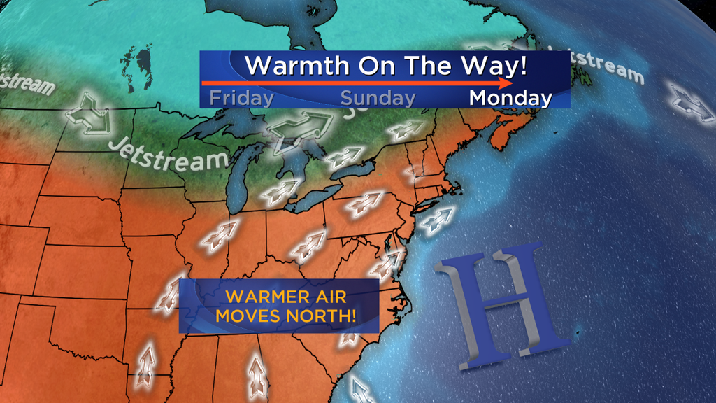
The long awaited pattern shift is in the works after this gray and cold May day, and we'll start adjusting the New England thermostat. While temps will start warming this weekend, the real ridge in the jet stream starts to take shape Sunday night and will be in control Monday.
A ridge in the jet stream is about as foreign as a Montreal Canadiens fan around here. Deep troughing has been persistent for months - bringing all that cold air that we can still feel in our bones. This change will help the warmer air amassing in the middle of the country to head our way.
There's an outside shot we may hit a 'surprise 70' in Boston on Sunday. But as of this writing, I think that the pressure gradient will be light enough on Sunday to encourage some afternoon sea breeze action, especially considering the sensor is located at Logan Airport on the water.
This should keep it from officially reaching the 70 mark. But southwesterly winds on Monday will deliver widespread 70s, and with temps at 850mb around +10C we may be able to sneak some 80s NW of Boston during the afternoon.
The air mass and ground are both pretty dry, and without leaves on trees this is a great recipe for an 'over-achieving' day of warmth. The party won't be for everyone, since southwesterly winds come off the water for the South Coast, Cape and Islands. Those locales will probably top in the low 60s. Still a vast improvement compared to what we've seen recently.
So the streak should end at 187 days on May 4th. It would be the 8th longest wait ever recorded for a 70 degree day in Boston, with records dating back to 1871. Notable but not unprecedented. And the good news here is that this pattern won't just be a slap on the back and a goodbye as soon as it arrives. This one finally has a little staying power.
There should be a 'blip' on Tuesday as a backdoor front drops down from the north. It will all come down to timing - if it settles south early then we may only top out in the 50s/60s. If it waits until the afternoon we could be up near 80. Those details will be worked out as we get closer. But overall the rest of next week looks dominated by dry, quiet, and pleasant weather with more 60s and 70s to come. It's the warmest forecast we've made since mid-October!
To go along with these warmer temps, expect a blossom explosion. Most plants/trees are running 1-2 weeks behind schedule. For Sunday and beyond, these babies are going to start putting on their summer attire.
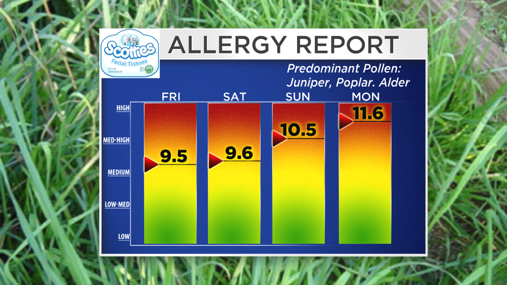
I'd expect tulips to blow open, many trees to flower, and the later trees to start budding. Dare I say we may hear a lawn mower or two by the end of next week. It also means that allergy sufferers will unfortunately have a rough go of it.
Pollen counts are expected to be very high this weekend through all of next week, so be prepared for the effects. Tree pollens are the main culprits this time of the year.
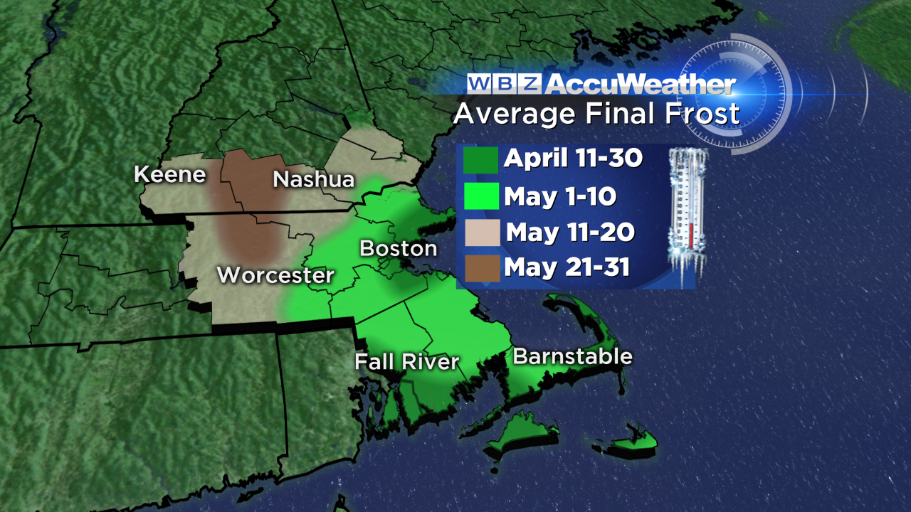
If you're getting out in the yard - you should know that no frost is expected Saturday night through all of next week. Certainly hanging baskets are a good option to pick up at the local garden shop, and colder weather vegetables are fine too.
Even annuals may be safe now close to the city of Boston (which has a much earlier final frost date than most of the region) - but be advised you may have to cover them one more time at some point in May if we get a cold shot.
The Cape/Islands are also heading into safer territory to plant. Summer veggies will still prefer warmer nights so it's generally too soon for that. By the end of the week we'll be at May 9th and clearing all of SE Mass's average final frost point. Doesn't mean we can't get another one, but the danger is definitely decreasing. Enjoy!