Why Doesn't Boston Set Cold Records?
WHAT?! May be your first reaction to the headline of this article. The landscape is still dead. Snow piles linger. You've been hearing about cold and snow for months now. In fact, it's going to snow today, April 8th. What is this crazed Meteorologist talking about? Of course Boston sets cold records. We set records for all things weather lately, don't we?
Well believe it or not, during these two very cold back-to-back winters, we haven't set a single record low. Not only these past two winters, but the past TEN. Not a single daily record low has been set in Boston in winter since January of 2004. To be precise, January 16th, 2004 during a particularly nasty arctic outbreak. During that same time, 12 new daily record highs have been set in winter (defined as December, January, and February - meteorological winter). Move it out even wider and only 1 record low has been set at all, in any month, over the past 8 years. And I'm here to tell you that this is going to continue to be the case for years to come, barring a major climate shift.
So what's going on? During the same time we've had record lows set in Worcester, Hartford, Concord, etc. There are three culprits involved that will help to keep cold records from being set at any significant pace going forward. The first is the Urban Heat Island effect, the second is the movement of Boston's reporting site, and the third is the overall period of record.
Part 1: The Heat Island
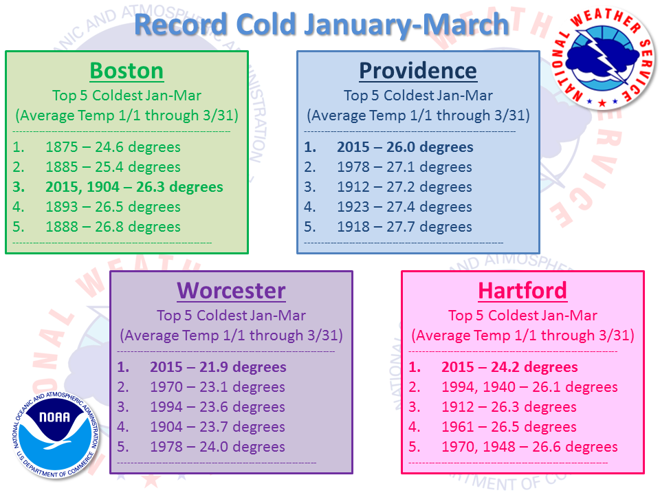
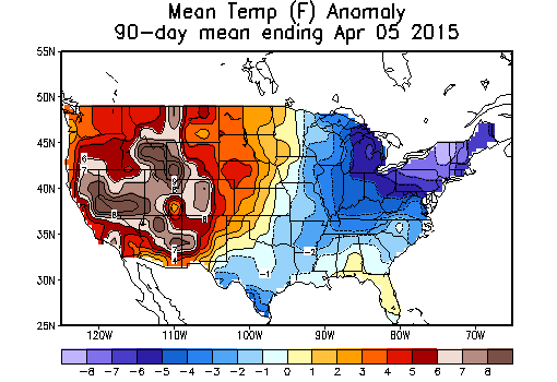
Consider the wonky numbers that came out of this past winter. February was the coldest month ever recorded in almost every New England city - except Boston. February 1934 still holds the title in the Hub. The combination of January through March, the first quarter of the year, was the coldest on record for nearly all of New England - except Boston. It was Boston's 3rd coldest. Not only did most cities achieve their top spot, but they crushed the old records. It's not easy to blow away an average temp record over 3 months time with over a century of data - but Hartford and Worcester managed to do it.
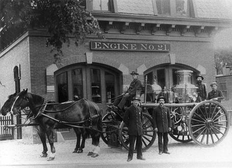
Engine 21's horse-drawn steam pumper at quarters on Columbia Road in Dorchester, circa 1872. Source: Boston Fire History
The most obvious reason is the Urban Heat Island effect, which we'll shorten to UHI. Weather records started in Boston in 1872, so picture the landscape then. Most roads were not paved...they were dirt horse paths or if you were lucky, cobblestone. The population of the city was 250,000 compared to the 646,000 that live in the city limits today. Buildings were more sparse, and the airport didn't exist yet. Are you back in time now? Good. Now think of all that has changed since then. More people, more buildings, more paving, more asphalt, more ways to absorb solar radiation. Surfaces like buildings and roads absorb and re-radiate much more heat than, say, water or an open field. So in general, it becomes more difficult for temps to cool off as development continues.
This effect is most felt at night, especially on nights with radiational cooling. That's when the winds are calm and the skies are clear. If you pay close attention to a weathercast, you'll notice that on these nights the suburbs are busy plummeting back into the cold while the city lags behind significantly. Sometimes Boston will be 20 degrees or more warmer than a town ten miles away. It just so happens that these types of nights typically are the ones that set cold records and bring the lowest readings of winter. While most towns saw over a dozen subzero nights in the winter of 2014-15, Boston saw only three of them.
When you look back through the records for the city, you'll spot the 1800s showing up frequently. Over 40% of all winter record lows set in Boston occurred from 1872-1899...within a mere 27 years. The others have been set in the 115 years that followed (or about 80% of the period of record).
Part II: Observation Site Changes
To go along with this, the observations have not always been made at the same location. The move to Logan Airport happened in 1936. Before then, it had several locations deeper into the city. According to the National Weather Service:
"The Boston Weather Bureau office was moved to "103 Court Street, Room No.10" on Jan. 10, 1871, thence to the Equitable Bldg., corner Milk and Devonshire Sts., "Room No.65," on Aug.12, 1875. On October 1, 1884, the Office was relocated to the Old U.S. Post Office and Courthouse, where it was to remain for 45 years until 1929. Young's Hotel served as interim quarters from June 7, 1929 to Sept.29, 1933, when the Old Post Office Bldg. was razed to make way for the new Post Office and Courthouse."
If we broaden out our search back in time and look for the winter record lows set before 1936, the figure jumps to a whopping 79%. The vast majority have held their ground for the 81 years which have followed. Clearly, it has become much more difficult to achieve record cold nights in the more modern era, and you need an increasingly anomalous setup in order to do it.
You can't just blame the UHI on this - the Logan Airport location is not fit to 'radiate out' like spots just to the west. I would guarantee you that on any generally calm night in winter, the temp on Boston Common would be a good 2-5º colder than the thermometer reads at Logan. Think about where that ASOS (automated surface observation system) instrument is - basically on an island. It's more difficult for air to go still next to the water, because thermal gradients tend persist longer there. If the air over land is 0ºF and the water temp is 33ºF, there is still going to be some air flow. The coldest temperature readings happen when a lack of moving air allows the dense cold air to settle right near the surface. Any mixing keeps this from happening. So by virtue of it's location alone, you'd expect milder nights at the airport than you would in the middle of Boston, and certainly Allston, Brighton, or Brookline.
Part III: Records Go Back To A Colder Time
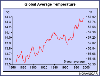
And on top of all this, you have the period of record - basically how long someone has been keeping track of things. Of all the Southern New England climate sites, weather records go back the farthest in Boston. I noted earlier how they started up officially in 1872. Well Worcester's didn't start until 1892, while Hartford and Providence didn't get going until 1904. This matters because in general, the 1800s were a very cold century. We were just exiting the Little Ice Age, and temps have in general gone up globally since. So the odds were stacked toward cold when Boston was starting up its period of record.
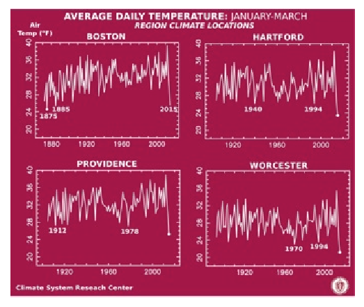
Source: UMass Amherst climatologist Michael Rawlins, manager of the Climate System Research Center
When you put all these factors together, it becomes pretty clear that having record lows outpace record highs is not going to happen unless the globe itself starts to cool off in a big way in the years to come. Does that mean it's not cold? No! To me, this past winter was remarkable. It should be regarded as the coldest in at least 140 years in our part of the country, if not over 200 years (per climate research by UMass Climatologist Mike Rawlins). There are very few people who actually live at Logan Airport last time I checked, and so long as the records are still falling in less industrialized locations, it is clear that most of our towns and cities just endured some exceptional cold.