A Final Winter Blast, Then Spring Arrives
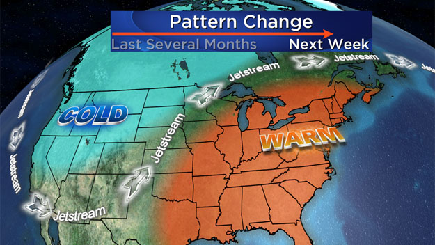
BOSTON (CBS) - Just what the doctor ordered. Could there be a more fitting end to this historically cold and snowy winter than hitting 70 degrees on Opening Day at Fenway? Well, that might just happen. Finally, there are signs that a significant pattern shift may be underway. And we aren't talking about a day of warmth and then another Arctic front crashes through, this warm spell could have staying power.
Beginning on Friday, we are likely to see several days near or well above the average temperature. When was the last time we said that? Try last year.
October 29th…remember where you were or what you were doing on that day about 160 days ago? Likely not. But that was the last time Boston had a temperature of 70 degrees or higher. It's been a while…a long while. As it looks right now, we may have several chances to hit 70 degrees next week, including Monday, Opening Day.
But, before we reach that glorious peak, we must endure one final blow from this relentless winter.
April can be a fickle month in New England. You can bet that for at least a week or two in April every year, New England will be the coldest spot in the country. While everyone else is basking in the warm sunshine and in full-fledged spring fever mode, many times we are left behind. This year has been no different. In fact, if anything, the temperature contrast between New England and the rest of the nation has been even more pronounced over the last few weeks. And that brings us to that one final blow I was talking about…Let's hope this is our last snowmap of the season…It appears as though we are in for a fairly widespread snow accumulation Wednesday night into early Thursday.
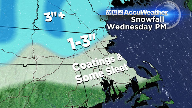
Timing
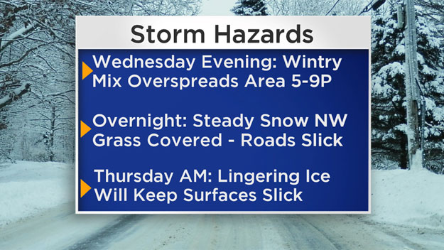
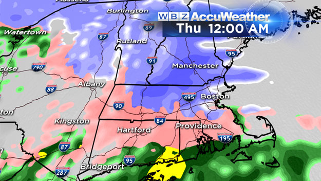
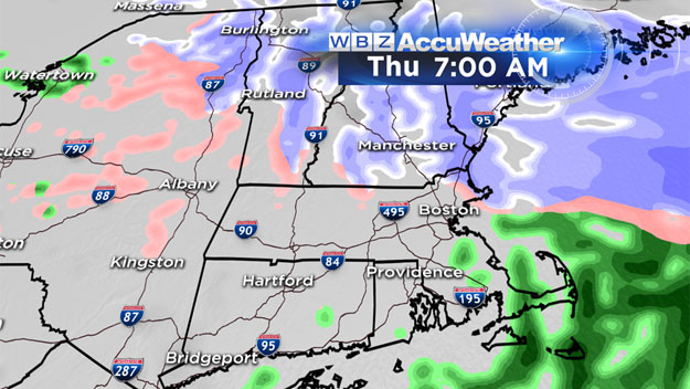
A mix of rain and snow showers during the day on Wednesday…no big deal just a damp and raw day. By evening, the precip will become more widespread and the atmosphere will cool a bit. Between 8pm and Midnight a wintry mix of rain, sleet and snow will envelope all of New England. In areas north and west of Boston, it may snow all night, not tapering off until dawn on Thursday! In Boston and down the Pike to Worcester, there will be more sleet involved and therefore less chance of accumulation. Along the South Coast and Cape, it is mainly all rain.
How Much Snow
- South Coast/Cape…nada, some wet flakes and sleet pellets mixing in with the rain
- SE Massachusetts, Immediate Coastline, all areas south of the Pike, including Boston…Scattered coatings, perhaps an inch on the grass in spots
- All areas north of the Pike from 128 to 495 and beyond…1-3" …main accumulation on the grass but many roads will either become snow covered or icy…travel will be tricky late Wednesday and into the Thursday morning commute
- Higher elevations of Vermont and N.H., perhaps Berkshires as well…3"+ here there is the potential with some elevation to top 3", perhaps get as much as 3-6"
The best thing about spring snow? It doesn't "stick" around long. Even though Thursday will remain cloudy and raw, much of the snow will likely be gone by days end. Whatever is still around on Friday will have no chance as much warmer air floods in. Temperatures will climb well into the 50s Friday and stay there through the Weekend! And next week, let the good times roll. 70 is a real possibility on Monday and it looks as though we will remain in the 50s and 60s for most if not all of next week! Signs of spring are going to pop up all over New England next week. It will look like Mother Nature just flipped the switch. Lots of buds, birds and bugs in the forecast!
Hang in there New England, the long wait is nearly over. Our turn is coming. Spring will never have felt so good.
Follow Terry on Twitter @TerryWBZ