Holiday Weekend Outlook - Will The Streak Continue?
Find Eric Fisher on Twitter & Facebook
Cold & snow, rinse wash and repeat. Yes, there are signs of spring around us. Snowdrops and crocus are starting to pop up out of the ground, red winged blackbirds are starting to show up, and grass is once again visible in many communities. But we're definitely not rocketing off into spring. We've had 10 straight weekends with at least *some* snow falling in the Boston area, dating back to late January. Looking forward there's some good news and bad news in the forecast, and I'd like to begin on an upbeat note so let's talk about the good stuff first.
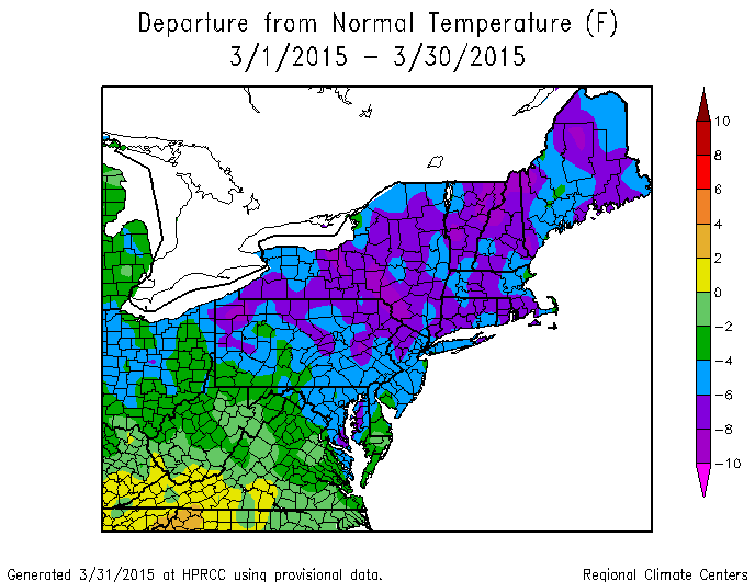
The coldest part of the country, relative to average, has been right here in New England for the past several months. Source: NRCC
A hearty welcome to April is in order! Boy has it been a long slog for the first three months of 2015. In some areas of New England, it has been the coldest Jan-Mar ever recorded. In modern times, it hasn't gotten any colder than this. I look at it as a potential positive. To start with, it's historic stuff. We've had a generational kind of winter, and one we won't soon forget. Maybe, possibly, we'll look back on it and entertain our kids with stories of the winter of 2015 with snow piled up over our windows. But even better - there's very little chance this will repeat itself next year. It would take an extreme turn of events to go from one of the coldest and snowiest winters ever seen in New England to an even colder and snowier one. So in the back of my mind, I'm already starting to look forward to winter 2015-16. I'm sure that will bite me in the butt come December.
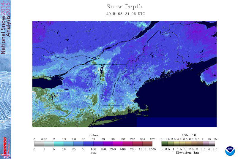
The snow pack is disappearing, albeit slowly. If this continues, we may be able to escape a big spring flood scenario. Areas of minor flooding are likely Saturday. Source: NOHRSC
The kickoff to our new month will feature bright skies, albeit with cool temps. We'll manage the low/mid 40s with a frisky breeze out of the WNW. With lots of sun and highs in the 40s, more gradual snow melt is expected. Many in SE Mass are now reporting more grass than snow, halleluiah! A weather watcher in Princeton wrote in to say there's still about 6.5" on the ground in the sunniest part of her lawn...so there's still quite a ways to go for a good chunk of Metro West, the North Shore, and Central MA - as well as southern New Hampshire.
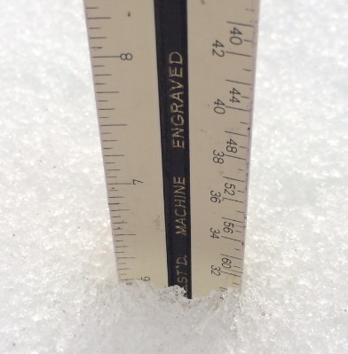
Still some work to do! Courtesy: Cathy in Princeton, MA
A period of significant melting will start on Thursday, in particular Thursday afternoon. We should eventually break into some sunshine and temps will jump into the low 50s once that happens. Above freezing temps are expected Thursday night, and Friday will bring widespread 50s with a chance of some low 60s, along with rain showers. The big question re: Friday temps is how far north a frontal boundary will move (isn't that always the question in New England?). I'm not 100% sold on 60s yet - there's definitely some uncertainty as to where exactly the mildest air will reach. The best chance is across Connecticut, Rhode Island, and southern MA (away from the immediate South Coast/Cape/Islands). It may be difficult to get to 60 around the New Hampshire border and points farther north. Either way a mild and damp day, and snow melt will be in full swing.
The mildest air of all will likely get forced northward Friday night as low pressure deepens and moves up across western New England. This track should keep us in the 40s/50s all night leading into Saturday morning, and will also deliver a slug of steadier, heavy rain. Some possible rumbles of thunder will go along with that rain, and some streams may go into minor flood on Saturday due to the combo of rain and snow melt. I like to try to ballpark exactly how much snow will disappear in a given time, and I think that nearly all snow will be gone south of the Pike (except snow banks/piles) by Saturday evening, and only patches to 3" should be left north of the Pike by that same time. Shady spots and banks will be sticking around longer, but it's definitely some solid progress. There's also a nice effect this can have - bare ground absorbs more solar radiation than snow does. Once the snow is gone, it becomes easier to heat up the air on a given day. We'll start to lose some of that natural AC that's helped keep us so cold.
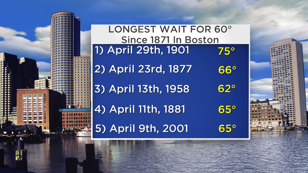
Will we do it on Friday? I'd say chances are better than 50%, but not much better. If Boston can't reach 60F on Friday, then it will be at least another week before we get a shot. That also means that if it doesn't happen Friday, it will be a 'Top 5' longest wait for our first 60 degree day. The city hasn't reached 60F since December 1st, while much of central Mass has been waiting since November 25th.
Saturday is probably the most interesting day of all when it comes to weather this week. The morning starts wet and mild, but as the storm heads toward Maine colder air will be drawn southward. It's one of those days where the number I put on the 7-Day makes no sense, because it all depends on the time of day you want to reference. It looks like we should go from 50s early in the morning to 40s in the afternoon and 30s by the evening! In short, temps will crash and it will feel much colder during the 2nd half of the day, with strong NW wind gusts picking up to bring in the cold.
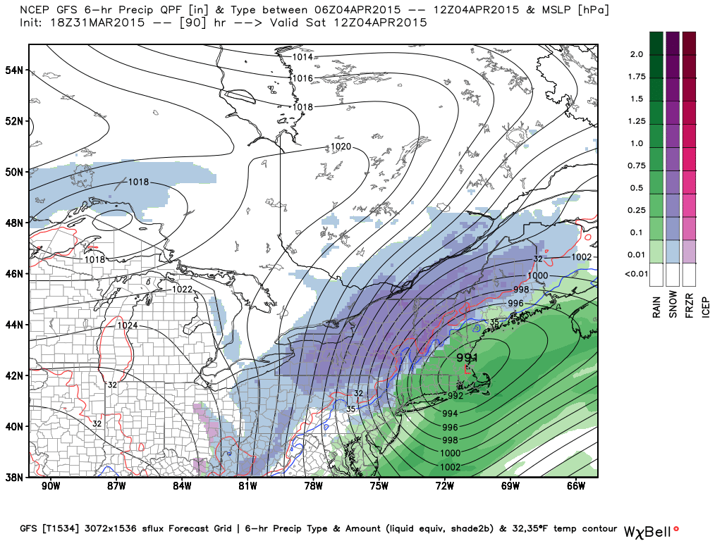
Tuesday 18z GFS depiction of Saturday morning across the Northeast. Source: Weatherbell
Then there's the snowy side of this - and there will be one. It appears the best chance for significant wet snow accumulation will be on a path across New York State (especially the Adirondacks) and heading into northern Vermont, New Hampshire, and Maine. Some freshies for holiday weekend skiers and snowboarders! A little wobble in the track could take that axis farther west or east, and definitely needs to be watched. There's even a chance that our rain could end as some wet flakes here locally, especially across northern Mass and into New Hampshire. Not expecting accumulation, but it could make for the 11th straight weekend with some snow coming down in the area.
If we don't do it Saturday, another chance will arrive on Easter Sunday. A trailing short-wave will diving into New England and could touch off some snow showers, especially late in the day. Either way it looks chilly with highs in the low/mid 40s. Since most of the snow will be gone we'll have one less obstacle for Easter egg hunts, but I'd definitely plan on some muddy conditions. It is April, after all.
Next week is a whole different can of worms that we'll update as we get closer. An active pattern should continue with the flow becoming a little more zonal. Pacific energy will start to dominate, and it looks to be like a long thermal boundary is going to set up all the way from the Plains to here at home. There will be plenty of cold air still lingering to the north of that boundary, and warm spring air to the south. What falls from the sky locally will have everything to do with where that battle ground sets up. It's likely that it will stay very cool (40s) for at least the first half of the week, and I can't rule out the possibility of more snow Monday and Tuesday. Higher elevations stand the best chance for now, but again we're talking many days in advance. Just something to keep in the back of your mind as winter tries to hold on a little longer yet.
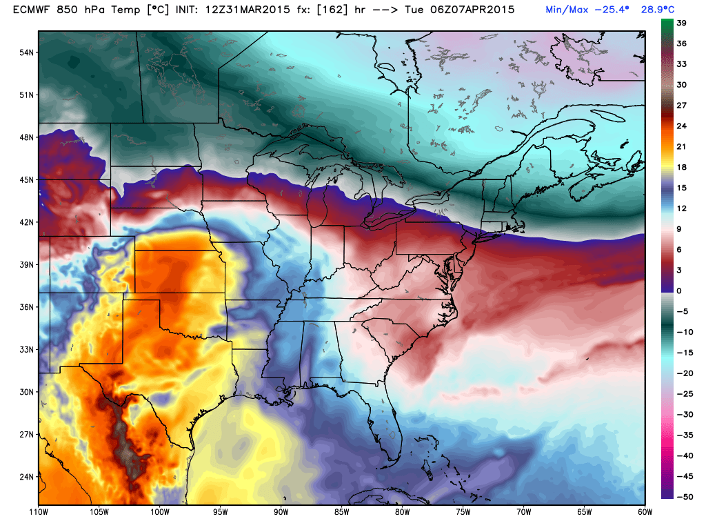
ECMWF 850mb temps for next Monday night. You can see the boundary between cold and milder air from South Dakota to Massachusetts. Question is where exactly this path for rain/snow will set up. Source: Weatherbell


