Eye On Weather: When Will Spring Get Here?
BOSTON (CBS) - It seemed like we had the never-ending winter just last year as the cold strengthened in March but it wasn't even close to being historical.
Well, times have changed and we are definitely living in historical times now.
The relentless snow and arctic chill of the past 30 days has been record-smashing and truly trying for everyone.
Read: More 'Eye On Weather' Features
Were you earlier lulled into thinking that it was going to be a wide open winter? After all, the mean temperature for December was an impressive 3.8 degrees above average yielding much rain and only 0.3 of an inch of snow. The switch was flipped in January as the temperature tumbled and the snow finally kicked in closer to the last week of the month.
Since then, much of the region has been thumped and dumped with an astonishing 100 inches of the white stuff! There never has been so much snow in such a short period of time. This crippling, paralyzing weather is more than a once in a century phenomenon. Seriously!
Winter Forecast Review:
On our "Eye On Weather: Winter Outlook" special in late November, I showed what I thought would be the biggest player in a host of global factors in creating our winter weather. It was this map here depicting a pool of warm water migrating eastward in the northern Pacific Ocean.
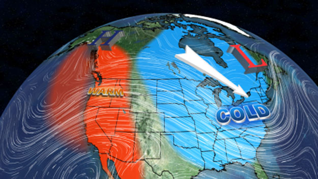
One year earlier, this pool was spread out across the Gulf of Alaska which resulted in atmospheric ridging over the eastern Pacific which produced a downstream axis of extreme cold and snow from Fargo to Minneapolis to Chicago to Detroit to Philadelphia.
As the pool shifted eastward, the expectation was that an axis of abominable weather would also be displaced farther east and north meaning New York and New England. Consequently, the WBZ-TV Accuweather Team delivered a prognosis for the winter calling for below to much below average temperatures and snowfall of 10-to-20 inches above average for the entire region which equates to 55-to-65 inches for the Boston area.
At that time, we felt that could very well be quite conservative, if not record-breaking. My neighbors were snickering at the giant snow sticks that I installed along my driveway and property bordering the street last November.
Although they looked silly into January, it was inevitable that the boom had to lower. And this massive snowfall has happened without North Atlantic Blocking which we expected to kick in during February.
Additionally, truthfully, our expected two-week break in December lasted closer to five weeks and the severe cold didn't set in until late January following tardy stratospheric warming and a more favorable Arctic Oscillation.
So our winter outlook wasn't 100-percent perfect but a few lines from my blog published on November 29 stated the general theme:
"In conclusion, the signals are flashing a rather harsh winter. We are relatively confident of a cold and snowy winter overall... we are highly confident that it will not be easy."
Spring 2015 Outlook:
How much more can we endure? Where will we put more snow? We have a problem!
Usually, these pools of warm ocean last about two years, meaning a cooling trend should commence soon but the ribbon of warm water in the eastern Pacific is presently modeled to persist through spring and that suggests masses of cold air will continue to charge out of Canada and plague us here in the Northeast.
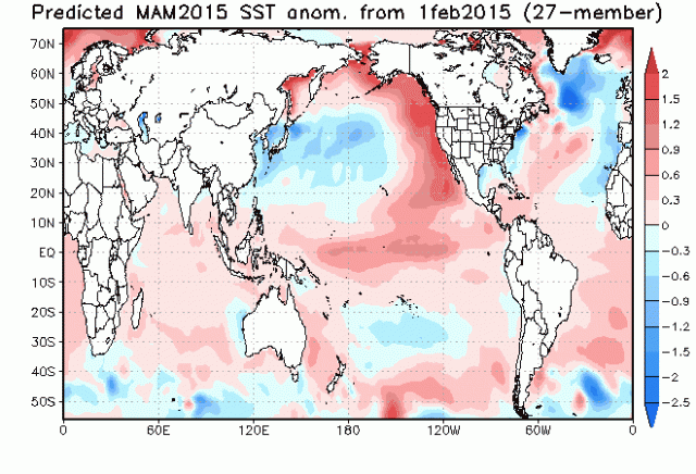
The Pacific Decadal Oscillation is popping positive or warm and the Pacific North American Oscillation is remaining positive which supports this prognosis.
On our winter special in November, we thought that this March would recover much more quickly than March 2014, suspecting that a more westerly flow of milder air would set in across the entire country.
That now looks to be delayed until April. That is when I believe that the odds increase for near to somewhat above average temperatures to return, as I think that western ridge should break down in a typical weak El Nino Modoki pattern.
With that said, we will still be vulnerable to bouts of cold air and chilly sea breezes as cold high pressure systems build across into the Canadian Maritimes.
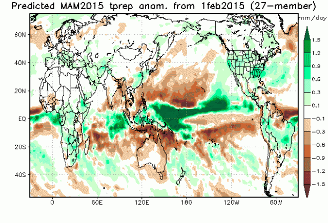
Above Average Precipitation:
The deep snowpack feeds on itself and supports cold and snowy weather sometimes. Furthermore, with other global factors in play matched with analog years, the potential exists for above average snowfall in March and near to above average precipitation in April into May, not only here, but nationally.
More specifically, that could amount to around 20 or more inches for Boston which would smash the all-time record seasonal snowfall of 107.6 inches by at least 10 inches!
That is insane! This scenario could indeed be a problem for more ice dams and collapsing roofs in the weeks ahead.
Going forward, ideally, we need gradually mild and drier weather to produce an orderly snowmelt.
So the prediction of cooler than average weather is a good thing, but with this outlook of above average precipitation in the next 1-to-2 months, wetter snows and rains along with the deep snowpack will raise the impact from potential for spring flooding.
Conclusion:
We have some tough weeks ahead, but as the sun gets higher and stronger, we can look forward to the eventual disappearance of snow followed by a greening landscape and the beautiful flowering shrubs and trees of late April and May.
We will soon spring forward one hour on March 8 as Daylight Saving Time Begins.
Sunset on that Sunday will occur at 6:42 p.m!
Spring officially begins at 6:45 p.m. on Friday, March 20 and the Red Sox home opener occurs at 3 p.m. on Monday, April 13.
One more thing - you can plan on this summer being hotter than last summer.
In the meantime, THINK SPRING.
Follow Barry on Twitter @BarryWBZ