Weekend Storm May Be Spring-Like For Some With Snow, Rain
BOSTON (CBS) - There is a light at the end of the tunnel!
Granted it is way off in the distance and barely visible through the snow, but trust me, it is there.
This weekend may be the first sign of hope.
We certainly cannot declare winter over, not by a long shot. Nor can we say we have had our last big snowstorm, also somewhat doubtful. But, this weekend's storm might just be the first sign of a change in this historic pattern. When was the last time we had a weekend without the mention of a foot or more of snow? Try mid-January.
Granted, we still have a storm coming Saturday night and Sunday, but this one is going to be very different, dare I say spring-like.
There will be some snow accumulation, but a surge of warmer air will introduce rain for a good portion of the area.
This isn't necessarily all good news however. The rain will add some serious weight to our enormous snowpack. With about 1/2-to-1 inch of rain expected in southeastern Massachusetts, many roofs will be tested once again.
TIMELINE
Let's break it down, flake by flake and drop by drop:
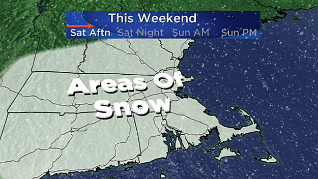
Saturday afternoon 1 p.m.- 7 p.m:
Snow begins between 4 and 7 p.m. from west to east, very light. Only expecting a coating to an inch (mainly north and west of Boston) by 7 p.m.
Saturday night 7 p.m. - Midnight:
Steady light to moderate snow through midnight for most of southern New England. This is the time frame of greatest snow accumulation.
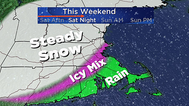
Areas north and west of Boston will receive about 2-to-4 inches of snow during this time. In Boston and areas south, a bit less due to milder temperatures, between a coating and 2 inches.
Sunday morning 12 a.m. - 7 a.m:
A significant push of mild air from south to north will change the snow to rain in some areas and an icy mix in others. The snow accumulation will largely be over with just a final inch or two in parts of central and western Massachusetts.
Snow will transition to plain rain in Boston and areas to the south. North and west of Boston, temperatures will rise above freezing a few thousand feet up in the atmosphere but right at ground level the sub-freezing cold will be tougher to dislodge.

Therefore, I expect pockets of freezing rain to develop in the early morning hours in parts of Worcester, Middlesex and Essex Counties as well as southern New Hampshire. Precipitation will be fairly light, so ice amounts should be near or below one-tenth of an inch, adding a crusty topping to the fresh snow.
Sunday 7 a.m. - Noon:
The mild surge continues and most of southern New England will climb to near or slighty above 32 degrees in this time frame. Parts of southeastern Massachusetts could climb to near 40 degrees!
Most of the freezing rain will change to plain rain, although some of the colder valley locations may remain just below 32 degrees well into the morning. In addition, the precipitation rate will slow down significantly during Sunday morning. The rain will become very light, turning to a drizzle north of Boston. The last of the steady rain will exit southern areas by midday.

Sunday midday/afternoon:
Precipitation tapers off and it's time to clean up again.
TOTAL ACCUMULATION
Three-to-6 inches:
North and west of Route 128, including Worcester, Fitchburg, Lowell, Lawrence and southern New Hampshire and Vermont.
One-to-3 inches:
Immediate coastline including Boston, South Shore, Cape and islands and all of southeastern Massachusetts.

WHAT'S NEXT?
Another shot of very cold, Arctic air for early next week. What else is new? The next storm potential looks to be around Wednesday. Still a ways to go with this one, could certainly be a miss, but it's something to watch.
Follow Terry on Twitter @TerryWBZ


