The Great Boston Blitz of 2015
Find Eric Fisher on Twitter and Facebook
"Winter is begun here, now, I suppose. It blew part of the hair off the dog yesterday & got the rest this morning."
- Mark Twain - letter to Chatto and Windus, October 21, 1892
That escalated quickly. Winters in New England are filled with intermittent bouts of joy, stress, and exhaustion for about 4 months, give or take a month. But none of them that anyone currently reading this (or their parents, or their parents parents!) have featured a blitz of snow like we have endured over the past two and a half weeks. In that time fences disappeared, two lane roads became one lane paths, and a lot of kids forgot that school is a part of daily life. What follows is the tale of what we've all seen unfold in rapid-fire fashion.
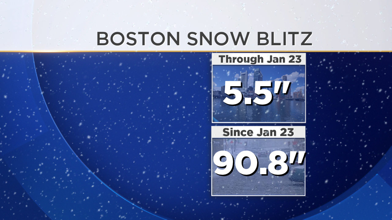
The first real flakes of the season started to float down in pleasant fashion on Saturday, the 24th of January. I remember it well, because it was that type of snow that doesn't force you to pull a 180 on all your plans but is enough to sufficiently transform the landscape. Most of us saw about a half a foot, and rejoiced in the fact that we could now break out our L.L. Bean arsenal and go snowshoeing, snowmobiling, or however else you try to enjoy the winter months. "Finally!" many exclaimed. And we were off to the races.
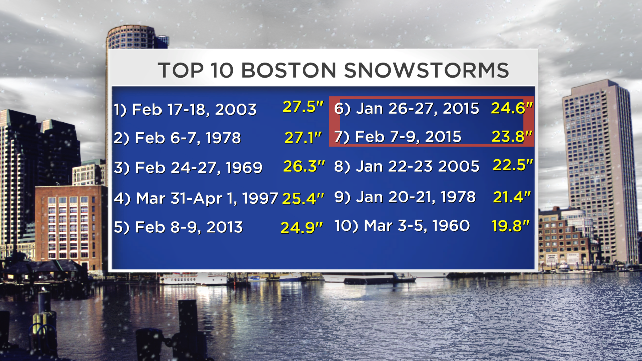
Then came the night of the 26th, and the state went quiet. We were asked to keep to ourselves at home as a blizzard moved in. The travel ban went up, the flakes came down, and at the end we had our 6th largest snowstorm in the recorded history of Boston weather (which goes back to the 1880s). Some towns were buried in three feet of snow, and coastal towns were inundated with the frigid waters of the Atlantic. "Alright, we're good now!" seemed to be the common sentiment. After all, we suddenly had already just about reached our average snowfall for the season. But still there were a few winter diehards who roared for more.
Wish granted! Phil poked his head out of the ground in Punxsutawney, saw his shadow even though it was raining, and proclaimed '6 more weeks it will be!' He may just be a quadruped, but the guy knows what he's talking about. Groundhog's Day brought another major storm in and along with it a couple feet more. Now that the drifts were starting to cover up the windows and cabin fever was taking control, even the snow hounds started to announce "Okay winter, we're cool. Thanks for the laughs but we're all set now." Not quite.
Then, another two feet blanketed the area during a longer duration storm February 7th-9th, and roof rakes became as popular as Sam Adams.The roof collapse reports started to escalate, especially for commercial property. Icicles more than 12 feet long started dangling off homes and buildings everywhere.
And then an unfathomable follow-up blizzard, the third storm in just a touch over two weeks to produce over a foot of snow! That's another feat that has never been accomplished so far as records go in the area. This must be unequivocal proof that Mother Nature is a Seahawks fan, because this is some serious wrath of weather territory. This storm was more dynamic, bringing an 'appetizer' round Saturday night of Valentine's Day before a ripping band of thundersnow and 4"/hour snow rates rocked eastern Massachusetts on Sunday morning of the 15th. A couple towns neared the two-foot mark AGAIN before the snow wound down. To add insult to injury, winds gusted 40-65mph and produced wind chill values of -25 to -35F. Ground blizzard conditions kept on going through the evening. The following morning saw the coldest temperature readings in 11 years, with Logan Airport coming in at -3F.
Individual storms claim their own glory and stand alone. The blizzards of 1888, 1969, 1978, 1997, 2003, and 2013 were all extremely impressive events. Many of them featured more wind, more flooding, lower central pressure, or an overall higher impact. But many of them stand alone. Even in 1978, when the infamous blizzard on Feb 6-7 was preceded by another huge snowstorm on Jan 20, there was at least a stretch to take a break. Highs topped 50 between the two, allowing for a little more space. But the cold we've been seeing is as much a story as the snow. We haven't touched 40 degrees since January 19th.
There's no doubt that this is a stretch that we'll all remember for many years to come. Chances are that it'll be talked about in the same type of vein as the '78 blizzard, even though the impacts of these events changes with technology and advance warning of incoming storms. Snow depth records are falling, seasonal records are in jeopardy, and there's still a lot of time left on the clock. Driving around to our live locations on Monday, I felt the fascination that makes most of us turn to Meteorology in the first place. It was like a movie set...mounds of snow bigger than anything I've ever seen in my life in this part of the country. Homes encased in drifts and icicles. Canyons that people had dug out to fit their cars, and street signs that had come within a few inches of completely disappearing. It almost didn't feel real, and I'm sure at least a few of you have had the same thoughts these past few days.
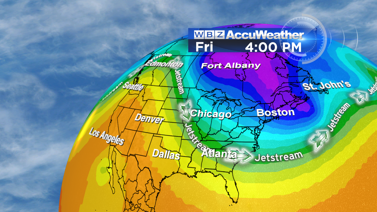
This remarkable pattern is being driven by strong Pacific ridging of the jet stream - which was the expectation heading into the winter. A warm pool of water off the coast of Alaska helps to build this ridge (and western warmth) and maintain it. The reaction to this is a deep trough over the east, which brings the cold and stormy weather. The warm pool migrated east from last winter, so the thought was that the ridge/trough axis would head a bit east as well. That has certainly been the case of late!
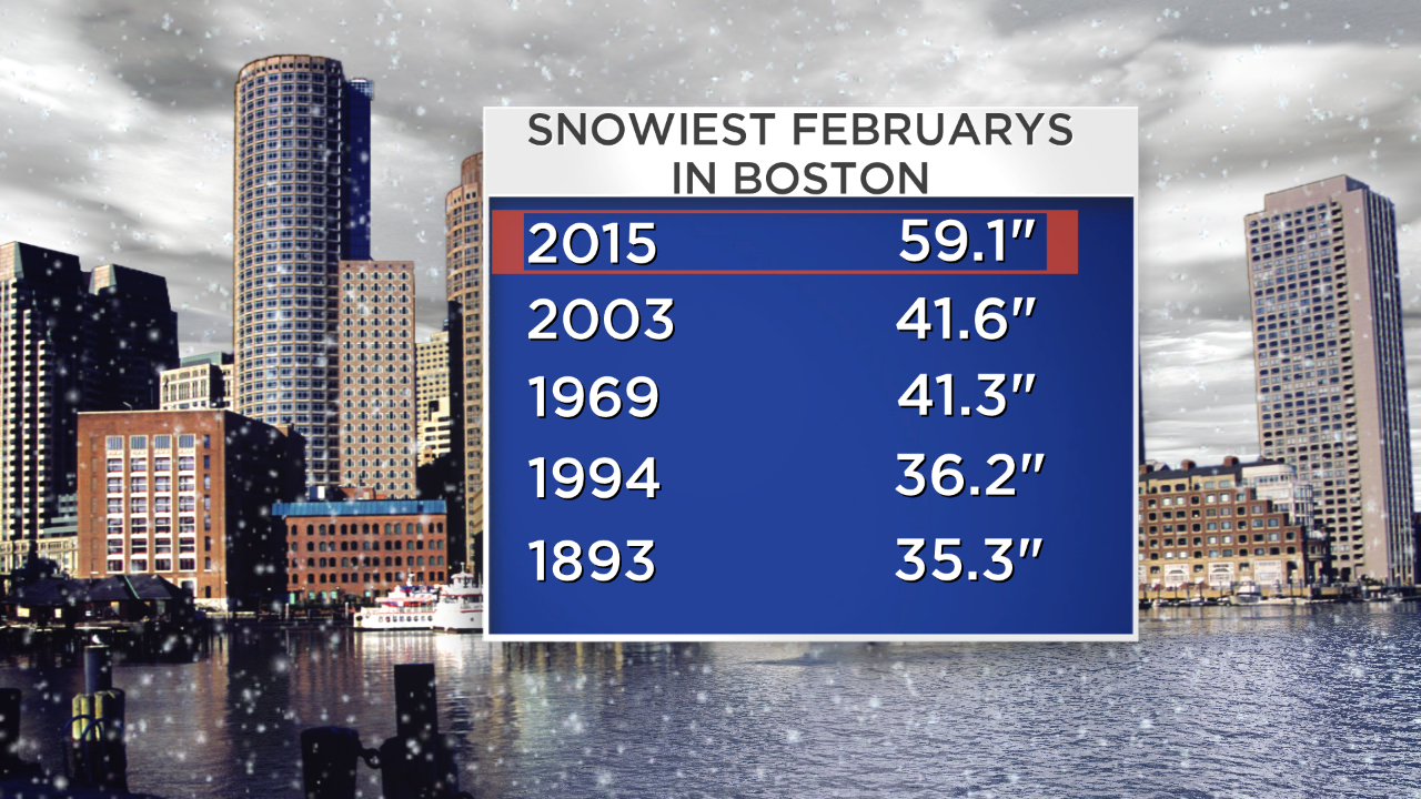
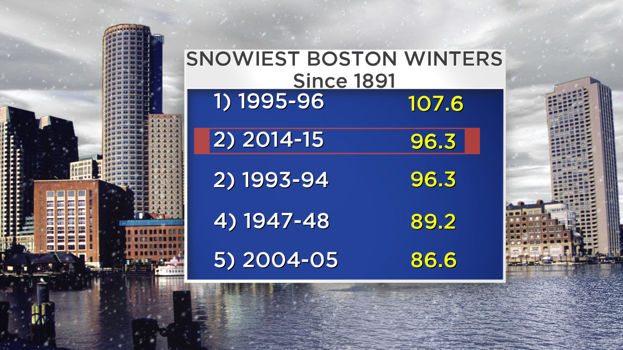
Can we take down the all-time seasonal record of 107.9" (Boston) set in 1995-96? I'd say the odds are looking good. This setup is generally locked in into March, and we're a mere <1 foot shy.
We're at the breaking point, so the hope is that these trends to the east stick. That's not to be dramatic, but to state a fact. The roof collapses are increasing, Boston's last day of school is already set for June 30th, and snowblowers can't shoot the snow high enough over the snowbanks that line our driveways. If we were talking about another foot in the short term (or even worse, significant rain), it could be the straw that breaks the camel's back. Hopefully that's a territory we won't need to wander into.
And of course down the road there's always the question of 'how will all this melt?' There's good and bad news there. The good news is that there's no rapid melt on the horizon. In fact, there's barely any melting at all. The majority of the next 10 days should feature below average temps (nearly all of them staying below freezing) and I really can't look into the long-range trends and find you a day that will reach 40 degrees region-wide. If there's no more snow, sublimation (ice undergoing a phase change via the sun and evaporating), compaction, and some minor melting....we can slowly start to bring down the snow pack. The absolute worst case scenario is more snow, then a wild pattern shift with big warmth and a rainstorm. There are no signs of that anytime soon, so we'll just have to hope that after this incredible stretch, Mother Nature will give us a break here in eastern New England.