Sub-Zero Temps Friday, More Snow Saturday Through Tuesday
BOSTON (CBS) - Snow fatigue is setting in. Is it just me or does it seem like it has been snowing for about two weeks straight?
Check: Weather Blog | Current Conditions | Share Photos
It is beginning to feel a lot like the movie Groundhog Day around here. Wake up, shovel, clean off the car, sit in traffic for hours on end, get home, shovel, go to sleep, repeat.
I wish I had some good news to deliver. I wish I could tell you that the snow was about to stop for a while. Heck, I wish I could tell you that our temperatures were going to be humane at some point in the near future. But sadly, I got nothin'.
Nothing but more of the same ol' story.
If you are nearing your breaking point, I would advise that you stop reading here. The rest of this blog is not for the faint of heart, reader discretion advised.
It starts with the cold.
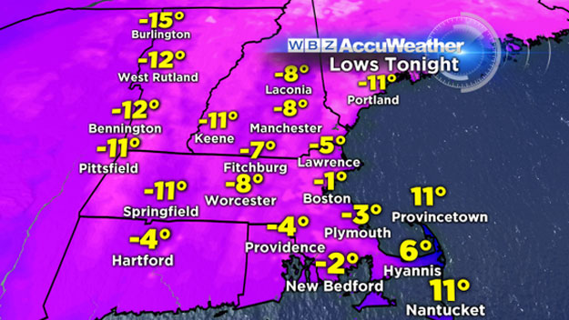
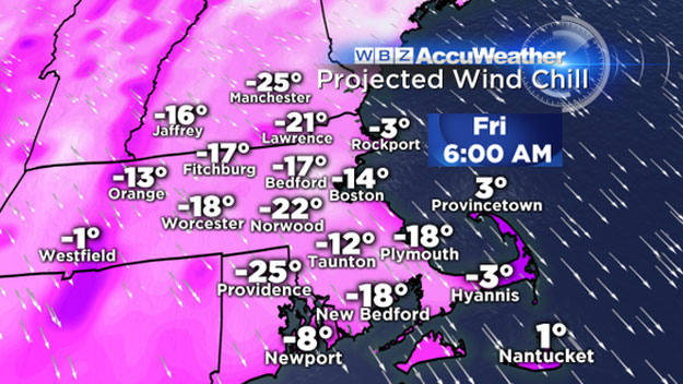
Friday will be one of the coldest days in recent memory here. Just about our entire region will wake up to temperatures below 0 Friday morning, perhaps even in Boston. Combine that with a gusty wind and it will feel like -15-to--20 degrees.
Temperatures will "recover" into the mid-teens for highs on Friday, but at least the wind will relax during the day.
If you begin having snow withdrawals on Friday, fear not, a steady helping is on the way.
Beginning Saturday, it will be snowing off and on for nearly three days in southern New England. I wouldn't call it a "storm" but more of a persistent, light-to-moderate snowfall.
So where is all this snow coming from?
Another cold front is going to come through during the day on Saturday sparking some more light snow. This front is going to essentially stall out to our south. This will create an atmospheric highway for small waves of low pressure to ripple along in the days to follow.
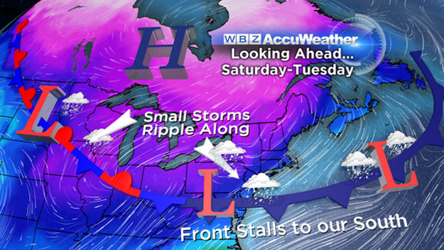
At the same time, a strong area of high pressure will be stationary over eastern Canada, providing a never-ending source of cold air and onshore winds.
The perfect setup for a prolonged period of light, powdery snow.
What's the Timeline?
The first "batch" of snow arrives late Saturday morning. A minor event, lasting through the afternoon, dropping a widespread coating to an inch or two.
After a small break Saturday evening, more snow arrives early Sunday morning. And from there it just keeps snowing and snowing and snowing, through the day on Monday, likely not fully tapering off until Tuesday morning.
If there were to be a peak of this storm, it would come Sunday night and Monday morning. This is when we could see the steadiest and heaviest period of snow accumulation.
How Much?
Given the fact that it is going to snow for about 72 hours (off and on) you would think this would be the storm of the century (nah, that happened a few weeks ago).
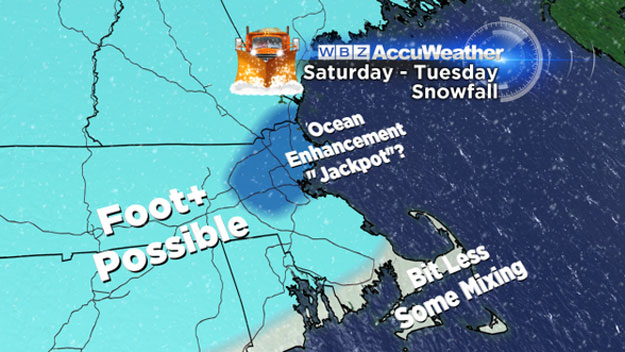
This is going to be a very light and gradual accumulation. Very manageable, no significant heavy bands, best way to describe it would be slow and steady. Early snow estimate right now: a widespread 6-to-12 inches of snow from Saturday morning though Tuesday morning.
Hard to pinpoint a "jackpot" area, but it would most likely be in Eastern Massachusetts, thanks to some ocean-enhancement.
Other Concerns?
Tides are astronomically low and the winds won't be all that powerful but, there will be several days with a stiff, onshore wind. Enough to rough up the seas a good deal and raise concern for significant beach erosion.
Hang in there folks. If you haven't learned to ski, no time like the present. All this snow is not going anywhere fast, might as well make the most of it.
There's plenty for everyone!
Follow Terry on Twitter @TerryWBZ