Staying In The Freezer For February
Find Eric Fisher on Twitter and Facebook
Okay, let's be clear here. We were starting to sweat a little bit in early January about our seasonal forecast. The balmy December was quite a surprise while we got doused with plenty of rain but no snow. The cold finally started pouring in for January, but still the snowflakes did not come. And then we hit January 24th and began an epic stretch of record-smashing snowfall over a short period of time. In short, now we wish we had gone higher with the snow forecast! Barry and I had kicked around the idea of calling for a 'near record season' for snow...and boy would we have some serious indigestion by MLK Day. But fortunes have reversed, the weather is doing more of what we initially expected, and the cold/snowy pattern is here to stay for a while. In fact, this is what the analog season we based a good portion of our outlook on (1977/78) did. A very slow start, and then the snow came fast and furious.
For Wednesday, we're not expecting much more. In fact it's handily the best day to have the Patriots victory parade in the city whether you agree with them going forward with it or not. In terms of the weather alone, it's the mildest day of the forecast. We'll hit the 30s, and while still below average it should feel fine out there after the cold early morning hours. Mostly cloudy skies are expected and a few snow showers, but think of them as nature's confetti to celebrate across the region. No travel issues should crop up.
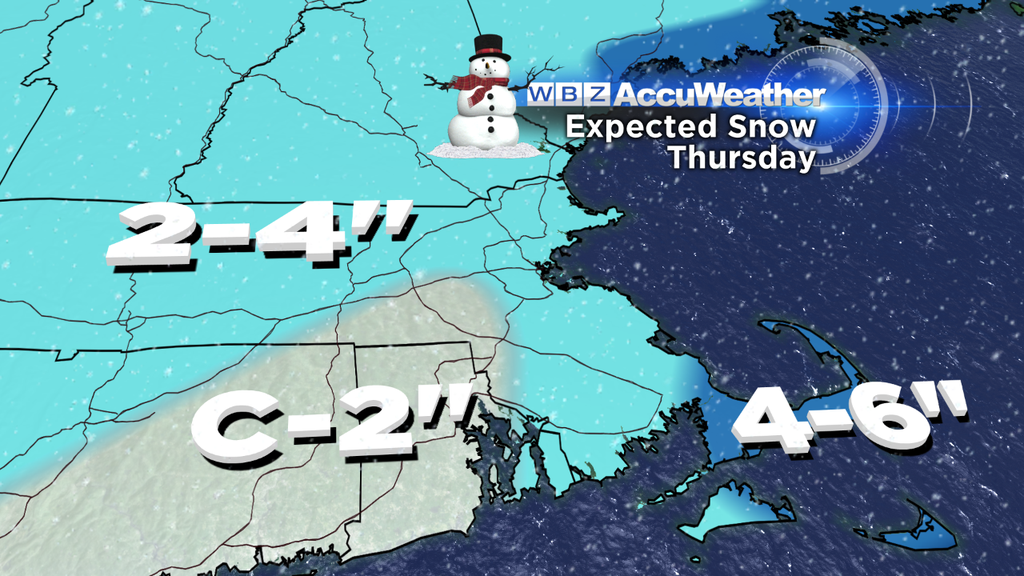
Thursday's setup is a little more complex. It kicks off Wednesday night as an arctic front moves our way. This should produce some snowfall late at night and into Thursday morning, so the am commute may turn out to be slow. Not expecting major accumulation, but 1-3" may be around for the early drive. The colder air will pour in as the day goes on, so high temps should be early (upper 20s to low 30s) and it'll feel much colder by the late afternoon.
Part two of this event is a wave of low pressure moving up along this front, which should at least graze the area Thursday afternoon and evening. It's a close call, but most of the steady snow should be impacting SE Mass or over the ocean. So that means the afternoon and early evening could still be quite snowy there, especially Cape Cod and the Islands where 4-6" is possible before the storm continues its track out to sea. Not a major event, but enough to require more resources in cleaning it all up.
The other part of the story is a renewed blast of frigid air, which will bring gusty winds and wind chill values down in the 0 to -25F range Thursday night and Friday morning. Highs likely won't escape the 10s for many on Friday....more than 20F below average. And as winds relax Friday night we'll probably end up with some subzero temps in the area again. Lucky us!
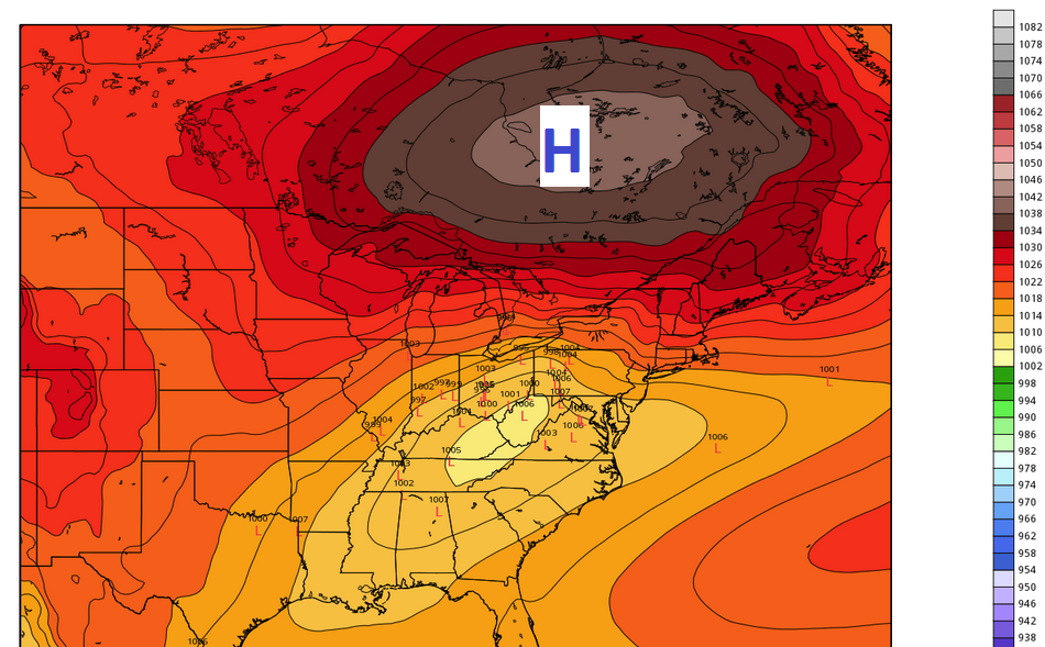
A weak short-wave blows through on Saturday with a chance for some flurries/snow showers, and then we'll turn our attention to the next threat. There's still a lot of uncertainty with this one, but the Sunday night into early next week setup needs to be monitored closely. A strong area of arctic high pressure will be situated over SE Canada while an area of low pressure heads east out of the Ohio Valley. There are a couple of possible outcomes here. The first is that the high is so strong that it shunts the storm off to our south and keeps us mainly dry (albeit very cold). The other is that the storm tracks nearby, gets slowed down by the high, we'll have a ton of cold air to work with, and the flow will be off the Atlantic Ocean for a long duration. Of course, no one is really rooting for that second possibility, but it's definitely a potential outcome and we'll be watching the trends for this all week.
Storm or not, it'll be very cold Sunday through Tuesday. It looks like *at least* the first 12 days of February will feature below average temperatures in the area. That's an impressive run of cold, and it looks like our thoughts of 'even colder than last year' are going to pan out. January was well below average (and colder than January 2014) and we'll need to be more than -2.8F below average to beat last February. A tall task for sure...but it'll definitely be off to the right start. The longer range points to more shots of cold and stormy weather well into the month...so even though pitchers and catchers will be reporting soon and days are getting longer...there is still quite a bit of winter yet to come.