Groundhog Day Nor'easter To Be Followed By Arctic Blast
BOSTON (CBS) - Six more weeks of winter? If the next six are anything like this week, we will be buried in snow until May.
Check: Weather Blog | Current Conditions | Share Photos
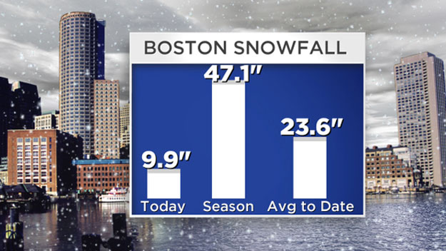
We are in the midst of one of the snowiest stretches in more than 100 years of recorded weather history. Boston has now exceeded 40 inches in just the past 10 days. Amazing when you consider the city averages about 44 inches for an entire season.
Same deal in Worcester where they will top 50 inches in the past 10 days. Sounds more like Buffalo right?
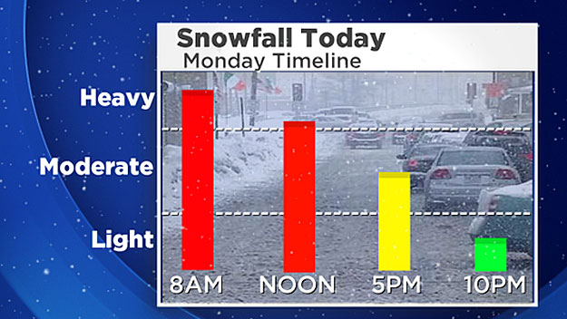
The worst of this Nor'easter will be over by afternoon, about 80 percent of the total snowfall will be on the ground by midday.
Here is a quick timeline to get you through the remainder of this snowy Monday:
2 p.m.-to-6 p.m. Monday
The snow continues but the intensity begins to lighten. Expect another 2-4" in this timeframe. Colder air will drain in from the north and push the rain, sleet, snow line back to the south.
A flash freeze will occur south of the Pike. Then, all of the rain and puddles will turn to ice as temperatures drop quickly.
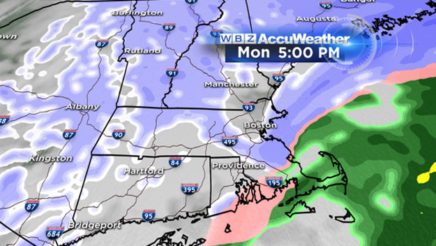
6 p.m.-to-10 p.m. Monday
The final moments of the storm. The last area of snow will push west to east across Massachusetts in this time period, dropping a final coating to 2 inches.
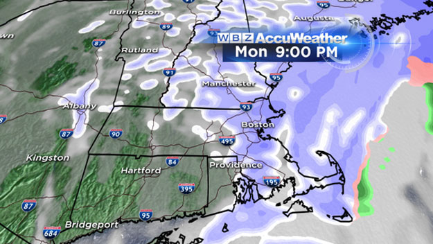
Approximate Final Flakes
Fitchburg/Worcester: 8 p.m.
495 to 128: 9 p.m.
Boston, coastline: 10 p.m.
Cape Cod: 11 p.m.
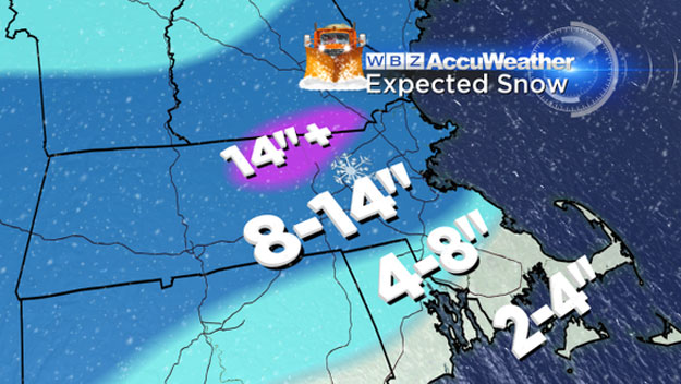
Final Snow Totals
Cape Cod/Islands: 2-to-4 inches with snow, sleet, rain and then more snow on top.
Southeastern Mass.: 4-8 inches
Mass. Pike northward, including Boston and Worcester: 8-14 inches
Northern Worcester County and northwest Middlesex County: JACKPOT ZONE 14-18 inches
Other Concerns
Winds
Peak gusts inland will only be about 15-to-25 miles per hour during the storm on Monday. Along the coastline, peak gusts will reach 25-to-45 miles per hour, nothing to sneeze at but about half of the peak gusts during the peak of the blizzard.
As the storm passes by overnight, the entire region will get gusty north-northwest winds.
Coastal Flooding
There will be a final high tide on Monday just after 10 p.m., but this will not be a major concern. Tides are astronomically low.
The peak of the storm will have passed. I expect just some pockets of minor flooding mainly over the South Shore and Cape. Seas and storm surge will be nowhere near the levels they were at during the blizzard a week ago.
Arctic Blast
A ferocious blast of frigid cold will arrive on the heels of Monday's nor'easter.
By Tuesday morning, nearly our entire region will be below zero. Wind chill values overnight Monday into Tuesday morning will be 10-to-25 degrees below zero.
Finally, the fresh snow will not be going anywhere. This will be a very cold week.
Temperatures will stay below freezing in nearly all of southern New England for at least the next seven days.
There is yet another risk of snow on Thursday from a potential coastal storm. Could be a sizable snow event or it may just scrape by to our south. More on this to come in the next 24-to-48 hours.
Follow Terry on Twitter @TerryWBZ