Here We Go Again!
Find Eric Fisher on Twitter and Facebook
Phew...it's been a busy week. Our Executive Weather Producer Terry Eliasen put together a great blog on the 'numbers of the blizzard of 2015' that you can read here. The snow deficit is gone, we had some more flakes to end the week, and now there's plenty more to talk about in the days to come. Winter around here can be funny like that. The switch gets flipped and we rock out an active weather pattern that accounts for a large amount of our seasonal snow. The crazy thing is - if we can manage close to a foot with the next storm - we'll have topped our average for an entire season in Boston already! It'd likely go down as one of the snowiest 10-day periods on record. Most got a half foot last weekend, another 30" or so with the blizzard, another few on Friday, and possibly another 6-12" Monday. That's ~50" in 9 days! And it doesn't even include the possible storm on Thursday. Oof.
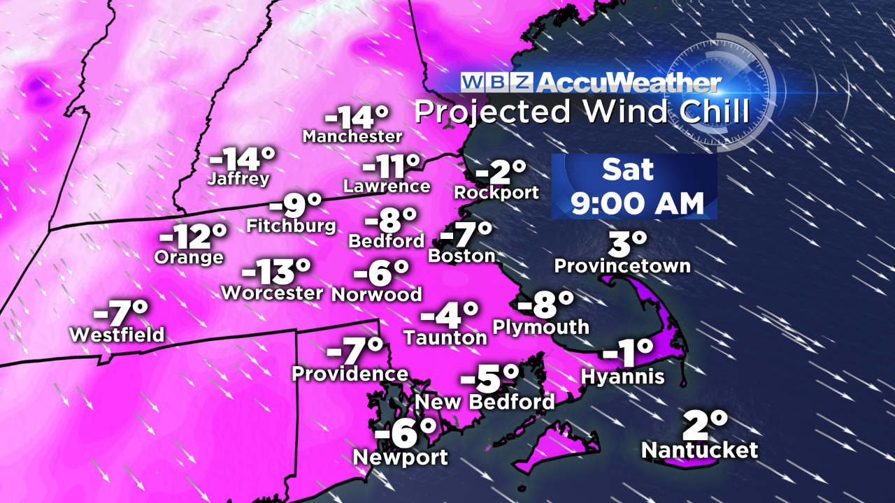
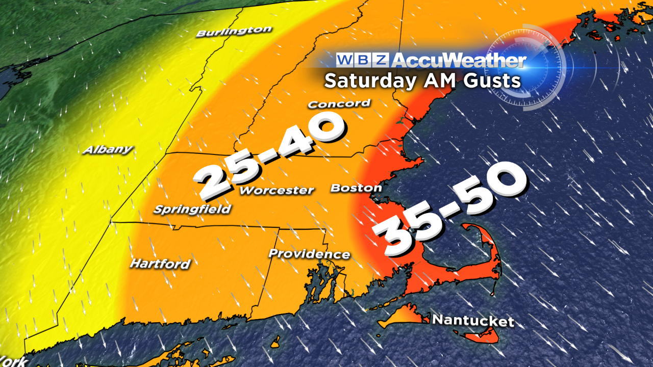
Just some thoughts on the weekend and beyond - we're kicking it all off with cold. We're actually lucky that we're not shoveling big snow again - a large storm is cutting off in the mid-levels and spinning off the coast of Maine. A hundred miles farther west and we'd get another foot. But this one's mainly a miss, and is more of a wind/cold producer than anything else here locally. Gusts will be 25-40mph on Saturday, possibly hitting 50mph along the immediate coast. With temperatures in the 10s, that will produce wind chill values in the 0 to -20F range. Probably a good day to cook up some Superbowl eats in the house and catch up on your DVR. With the well below average temperatures for the final day of the month, this January will be the coldest in 11 years (2004 is the coldest January on record since the climate site moved to Logan airport).
Sunday looks cold and quiet...with a chilly breeze and increasing clouds. At this point we'll turn our attention to the west as the storm which is currently pouring buckets over the Superbowl festivities near Phoenix heads out into the Midwest. This storm looks to channel some decent moisture and will lay down a strip of snow from Iowa to our doorstep...stopping in places like Chicago, Indianapolis, Cleveland, Pittsburgh, and NYC along the way.
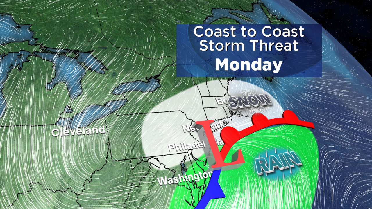
The good news is - the storm arrives after the Superbowl ends. Don't have to worry about potential power outages or bad travel heading out to hang with friends for the big game. Right now, the timing looks to be a bit after midnight for the initial snow. Overall this storm doesn't look like a big nor'easter or blizzard....more of a snow maker than a flooding/wind event.
Snow is expected for most of Monday, which is both great and bad news. It's great because many may get a snow day after the Superbowl...which is typically one of the biggest days of the year to call out from work. You'll get a little Groundhog Day breather before getting back to reality. But of course, there's a big issue with schools and the question of 'where do we put all this?' Some school districts, especially on Cape Cod, have been out for the past 4 days. If there's no school on Monday, that will make a full week without any class in a row. Not good news. And since there will be very little melting this weekend, the snow banks are still going to be high. Another foot of snow is not what the region needs.
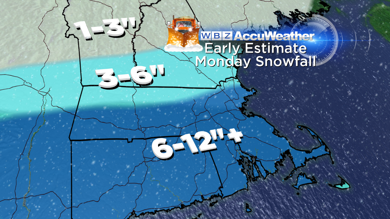
At this point, there's pretty solid model agreement on this band of snow gliding over us and providing widespread 6-12" snows. There may be a stronger band somewhere in that strip where totals top a foot...but it's a little too early to know for sure if that's going to be the case. So where we stand as of this writing is that you should expect a snowy Monday but not a major storm like the one we just saw. Of course we'll keep you updated all weekend.