Four Storms Over Seven Days Possible For New England
BOSTON (CBS) – As New England continues the big dig after the historic blizzard, Old Man Winter is not showing any mercy.
We remain in a very active weather pattern for the foreseeable future with a seemingly endless supply of cold and snow.
Watch Eric Fisher's Latest Forecast
Four snow events are possible in the next seven days. Here is a brief summary of what each one may bring.
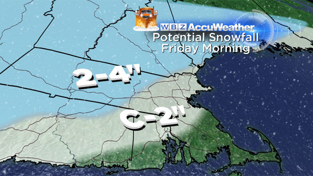
Thursday Night-Friday Morning
This is the first and perhaps the weakest of the coming "storms." There is currently an area of rain and snow showers moving through the upper Midwest and headed into New York. This is a system that is somewhat moisture starved but will contain just enough to make for a messy Friday morning commute. First flakes arrive around midnight and the steadiest snow burst occurs between 5 a.m. and midday Friday.
Check: Weather Blog | Current Conditions | Share Photos
There will be some mixing and rain along south coastal Massachusetts and Cape Cod, so no snow accumulation there. From Providence to Boston and most of metro west, expect a coating to an inch or two of snow by midday Friday. Slightly higher amounts (up to 3") may accumulate in central or western Mass. including Worcester Hills.
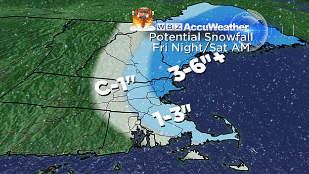
Friday Night-Saturday Morning
When storm No. 1 hits the Gulf of Maine, it will get a shot of adrenaline and begin to rapidly strengthen and deepen. As it does so, it will throw back some heavy bands of snow towards the New England coastline.
The timeframe for this event would be between midnight and midday Saturday. The brunt of this storm will be felt in coastal Maine where 6-12" of new snow is a real possibility. In Southern New England we are looking at about 1-3" mainly confined to Eastern Massachusetts (Interstate 495 and east). Best chance of seeing 3" or more would be in Essex County and southeast New Hampshire where 3-6" is possible.
Monday Storm
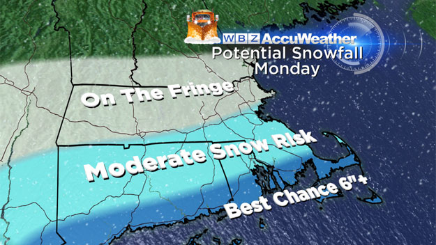
The stakes are a little higher with this storm. It will be a much stronger, more significant storm, drawing in Gulf of Mexico moisture and affecting a good portion of the Ohio Valley and Mid Atlantic area before arriving here on Monday. The big question to be determined yet is the ultimate track of the storm.
Right now it appears as though it will take a track a bit too far south of New England to give us a major blow. However, it is still early and it wouldn't take much change for a significant swath of snow to push into Southern New England. For now, the forecast is for a glancing blow on Monday, some light to moderate snow during the day, steadiest along the South Coast. It's too early for snow accumulation projections, but several inches are possible south of the Mass Pike.
Wednesday Night-Thursday
Obviously if it is too early to get specific on Monday's storm, it is waaay too early to go there next Thursday. This is just a brief heads up that there *could* be another snow chance later next week.
Like I said, we are in the midst of a very active and cold pattern.