Patriots Outlook: Wet & Chilly
Find Eric Fisher on Twitter and Facebook
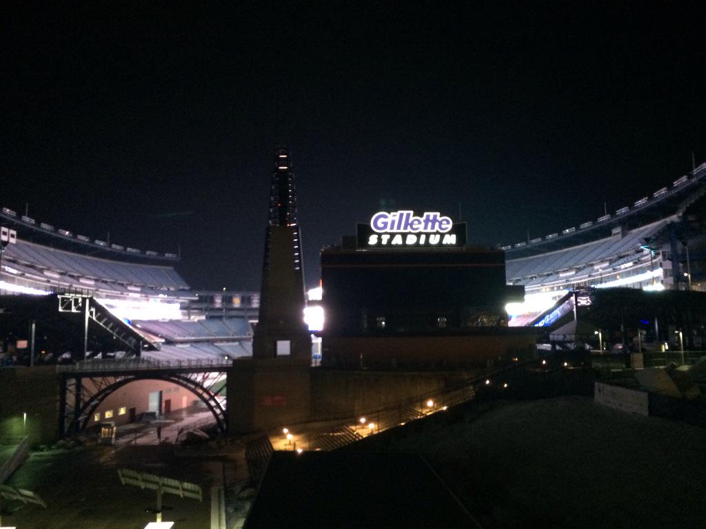
Gillette Stadium on an icy Thursday night. Photo by @tbone51558 on Twitter
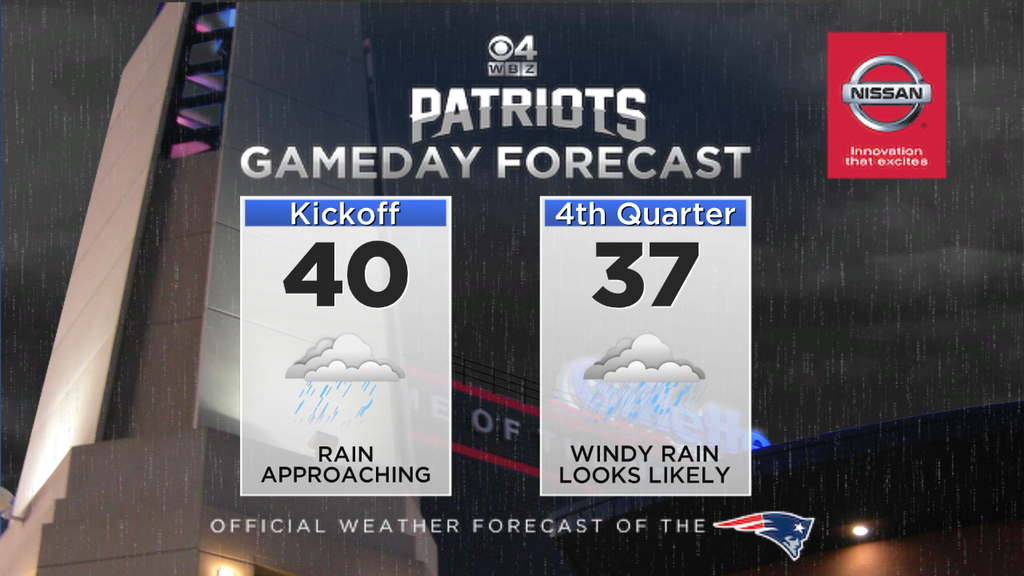
**FRIDAY EVENING UPDATE: After drawing one day closer and getting more data, the forecast details are looking more in focus. It appears that plenty of mild air is going to come in at the surface and aloft with a deep southerly flow, so that confirms we're talking about mostly a rain event. If the track moves a little farther west, then temperatures will end up a bit milder (potentially mid 40s). If it tracks a bit farther east, then a touch colder (falling into mid 30s). But I think within a few degrees of 40 is looking like a good bet.
As for rainfall - looks like anything between midday and early evening is going to be showery in nature...more of a nuisance than a problem for tailgaters. I'd bring the rain gear but it doesn't look like consistent wet weather will be in the area yet (it'll be in western/central New England). Misty/mild-for-January conditions are expected pre-game. The chances for steady rainfall go up after 6pm, and especially after 8pm. So if anyone is going to get soaked, the best bet is toward the end of the game or during the walk home. Could be pretty nasty out on the streets post-game 10p-1a as that's when some of the heavier downpours look to arrive. As always, stay tuned for any updates if the forecast requires tweaks this weekend....and Go Pats!!
------------------
Well, we already know 'The Hoodie' doesn't necessarily care too much for meteorologists and their prognostications. But we're on the to the next storm. On to the next storm. On to the next storm. And you know what? We're just setting him up to chuckle again, because the forecast for Sunday night is looking exceedingly difficult at this point. There are still some questions to be answered about where this thing tracks and how strong it becomes. But the picture has become much more clear now that we're two days out, which is good news for all.
So here's what we have at this point. A shot of arctic air is pouring in Friday, and will halt temps from rising any more than the upper 20s (west) to mid 30s (southeast). By the evening a familiar bite of winter air will be back in action with temps falling and gusty winds providing wind chill values near zero. By the time you wake up on Saturday most towns will be in the single digits, with subzero temps farther to the NW of Boston. Hey, at least the wind will be gone! High pressure crests over the region on Saturday which will provide a calm but cold day with highs in the upper 10s to mid 20s.
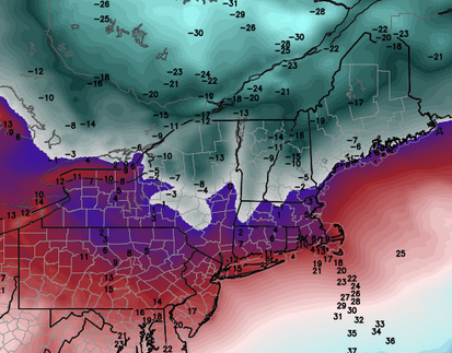
NAM forecast lows on Saturday morning. These are probably a bit too 'mild' but give a good idea. Plenty of subzero temps north of the MA border, a few in MA, and lots of single digits otherwise. Source: Weatherbell
Heading into Sunday, that cold air will still be standing in place. We'll likely fall back through the 10s early Saturday night before temps start to rise a bit toward Sunday morning. And you know what cold air likes to do - stay in place. It's hard to dislodge and so this is one of the critical questions we need to answer before too long - how much of that cold air will remain when the storm arrives on Sunday?
The coastal plain will likely climb into the 40s, but it may be hard to reach/top 40F across the interior Sunday afternoon. Foxboro sits between those two zones - not as easily warmed as the South Coast, but more susceptible than central Mass. Current thinking is that temps close to 40F will be possible leading up to game time. That's just mild enough for a mainly wet and not white forecast.
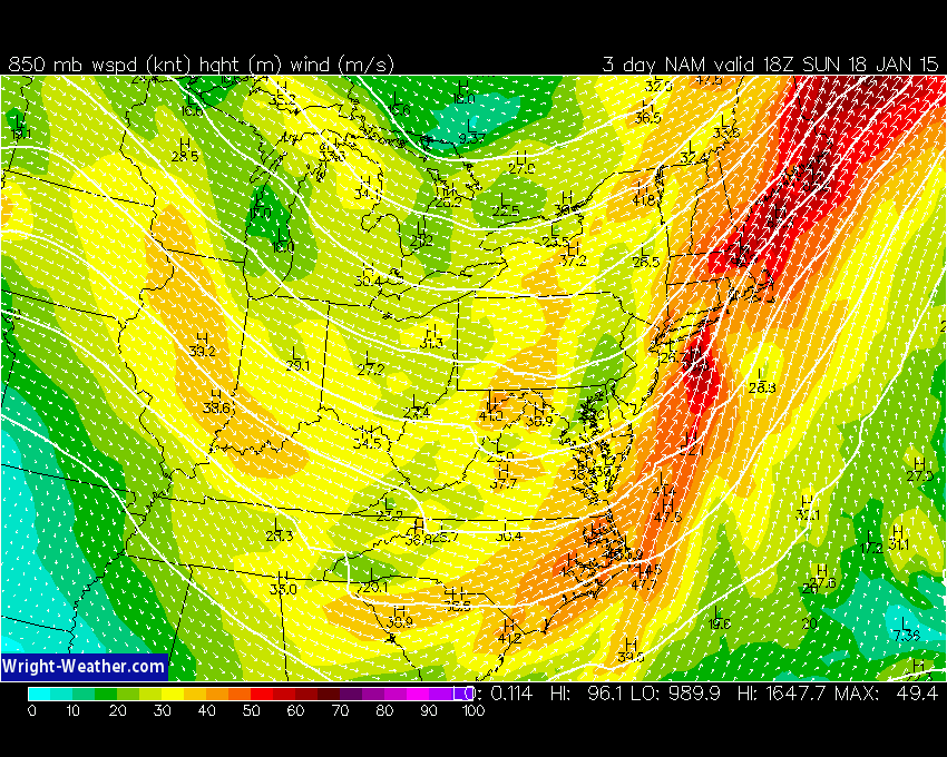
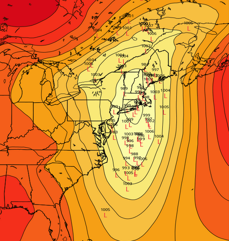
NAM forecast winds at 850mb on Sunday. Straight from the south, bringing milder air in aloft. Source: Wright-weather.com
Another factor to look at is the way in which this storm is moving toward us. Wind flow will generally be southerly aloft, so milder air (air that's above freezing) is likely going to move in pretty quickly and kibosh snow potential for most of the area, at least initially. There may be some sleet and ice issues to keep an eye on farther north across the interior, but not in Foxboro. While temps around 850mb are expected to be +2C, temps at 925mb are expected to be around +6C and be above freezing well to the north. Snowflakes can't make the trip through a layer of air that warm, and so this is another check mark in favor of rain.
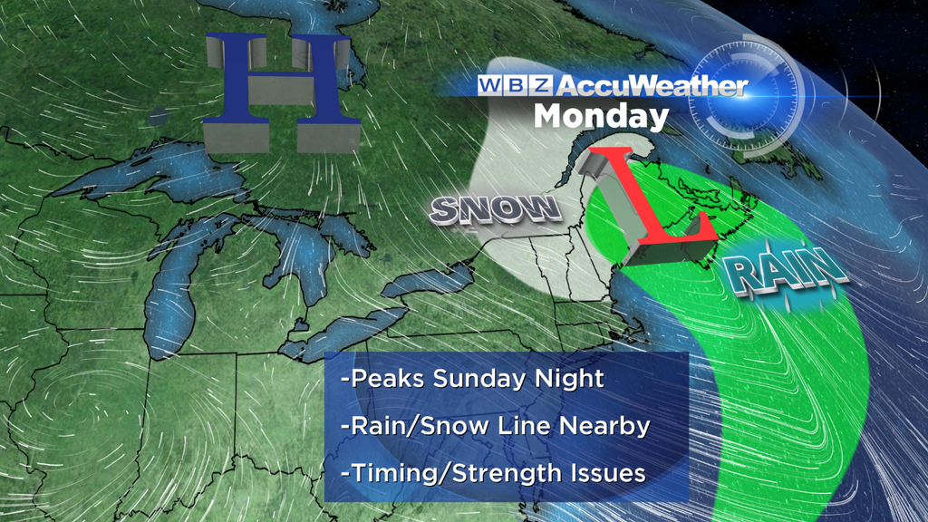
For now, it looks like rain should start to develop by mid/late afternoon, but the chances increase as the game goes on. There's a shot that some of the tailgating will stay dry before this rain moves in, but again check back in on Saturday to see if the timing has shifted at all. In any case the highest probability of steady rain is toward the second half and for the (hopefully) happy walk through the parking lots after the game. Who cares about cold rain, we'll be going to the Superbowl, right?
If you're a snow lover, it's looking like the Capital Region of NY, the Berkshires, and VT/NH/ME may be the best bets. A BIG question right now is the strength of the storm. While some models are indicating a strong negative-tilt trough digging in with bombogenesis taking place Sunday night, others are much more benign with a streak of rain/wet snow moving through and then heading out on its way. So this is the main focus over the next 24-36 hours - nailing down whether or not we're going to have a powerful storm that wraps in cold and swings snow/ice back through the whole area Sunday night/early Monday. A rapidly intensifying storm would also feature very strong wind gusts for SE Masachusetts, with gusts over 50mph not out of the question.
The full spread of ECMWF EPS members for Sunday night. That's a lot of potential territory still in play. A more easterly track could drag the snow line east, but a storm over the top of us (or west of us) will keep most of the area all rain until the very end. Source: Weatherbell
Looking at ensembles (always a great tool when looking farther out in advance) there is LARGE spread. Possible low location and intensity is very wide, wider than it typically is 3 days out. The vast majority of ECMWF EPS members do *not* predict significant snow in southern New England, which is important to note. Seems like even when we're mired in a very cold stretch (this January is going to end up much colder than last year) it warms up just in time for a storm.
We'll keep you updated over the next few days but be prepared for chilly air and wet conditions for the game. I think we can all agree that the worse the weather gets, the more it favors the Pats.
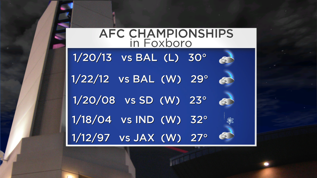
So long as the kickoff temp is above freezing (very likely) this will be the 'warmest' AFC Championship game played in Foxboro for all of the Brady/Belichick area and beyond. Data is via the WBZ sports department and the New England Patriots.


