Looking Ahead: Brief Thaw With An Arctic Finish?
Find Eric Fisher on Twitter and Facebook
Not shabby! Many of us saw our local rivers, streams, and ponds freeze up over the past week of well below average temperatures.
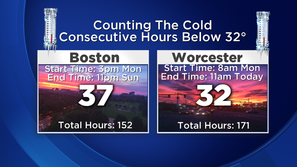
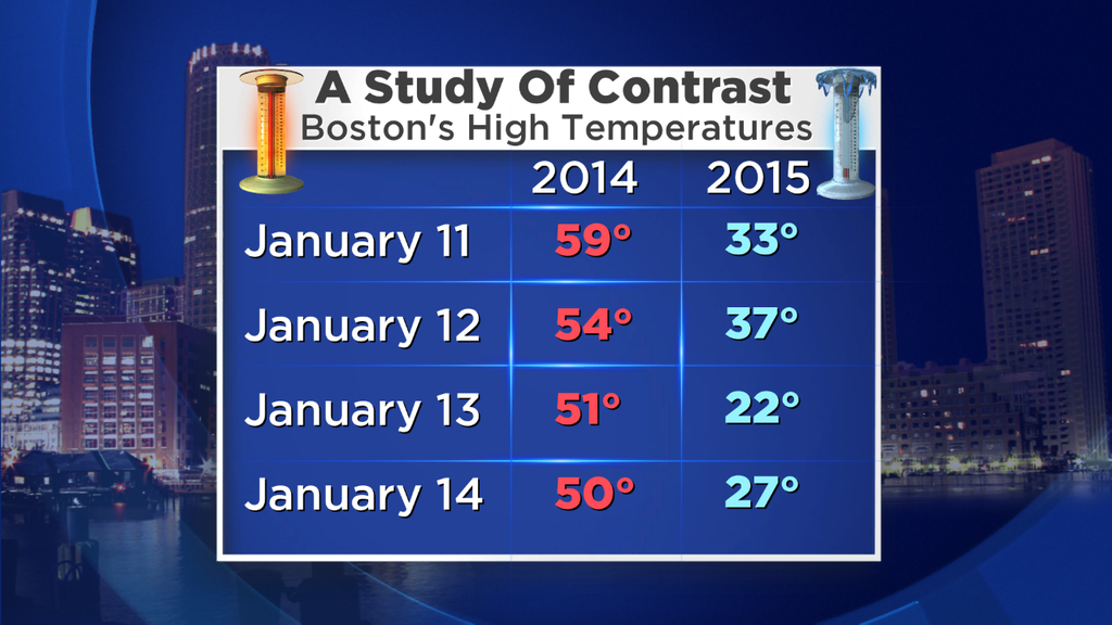
Monday snapped what's been the coldest stretch of weather this winter, with temperatures finally rising above freezing for a few hours across the area. We went a solid 6 straight days below 32F, which only happened one time all of last winter (in February, 7 days straight). Makes total sense as this is, on average, the coldest point of the year. Which is good or bad, depending on your preferred flavor. And whether you're in the camp looking for milder air or the one rooting for more cold, I think both can be pleased before January ends.
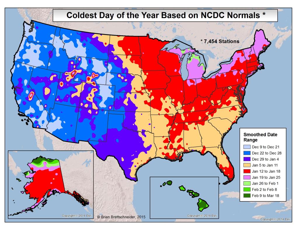
A glance across the country at when the coldest day of the year occurs, on average, via @Climatologist49 (Twitter) We hit the climatological bottom this week.
In the near term, today is a return to the frozen tundra. Most will stay in the 10s to low 20s all day, and with a gusty wind that means wind chill values down near 0F. We'll also be watching the Cape, Islands, and South Shore up toward Plymouth for some ocean-effect snow activity. A coating to an inch or two is expected from these bands, and there could be a few areas of poor visibility mainly from mid-morning through mid-afternoon. These bands are the product of instability generated by cold air aloft and the still relatively mild ocean waters. Once you get a good enough difference between the two, you're good to go! Of course, skies will be grayer in these same locations. Lots of (ineffective) sunshine will dominate interior parts of the state/region.
As winds calm down overnight, most interior locations will go well down into the single digits. I wouldn't be surprised to see some subzero numbers show up again, especially in central Mass up into New Hampshire and Vermont. So much for our brief thaw...those ponds and lakes will return to freezing up. Just be careful if you decide to go out on the ice...the freeze/thaw cycle can be a dangerous time to get out there.
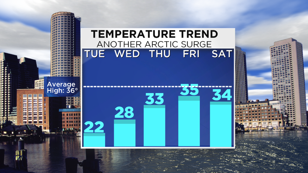
Then rest of the forecast is pretty 'bleh' by January standards. Upper 20s and quiet on Wednesday, low 30s for Thursday and Friday's highs. An ocean storm should stay out to sea sparing us any significant precipitation, but clouds will be more persistent across SE Mass due to its close pass. A cold front moves through with perhaps a few flurries late Friday, and that air mass will keep us near/below average on Saturday. Ahead of the next clipper, we may be able to squeeze out some mild air for Sunday. Early indications are that we could climb up into the 40s for a day, just in time for the Patriots. Sunday is also the day that the models really start to disagree on how things will play out, so monitor that game-day forecast for any changes in the days to come. There may be a few rain/snow showers to contend with, but none of the harsh cold we saw during the divisional round.
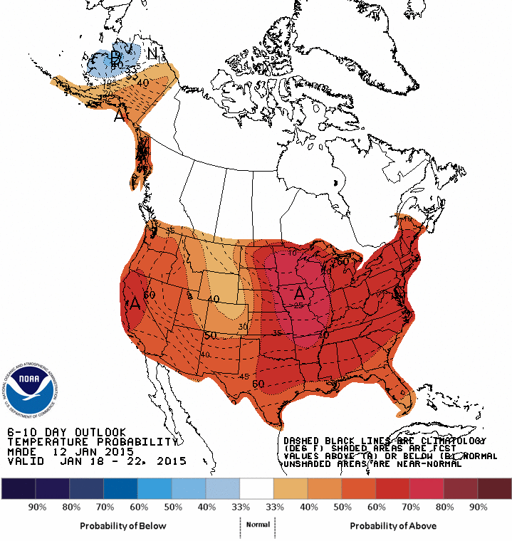
The Climate Prediction Center's outlook for next week. Most of the Lower 48 looking at a high probability of above average temperatures.
Looking into next week, we may get our 'January thaw.' Most indications are that milder air will flood the country and we should be able to string together some days of temperature into the 40s. I had completely blanked it out of memory, but this time last year was when we received our January thaw. We strung together 10 days of above average temps, including four of them up into the 50s! Was actually pretty surprised to look back and see that...I had remember the month as a purely cold one.
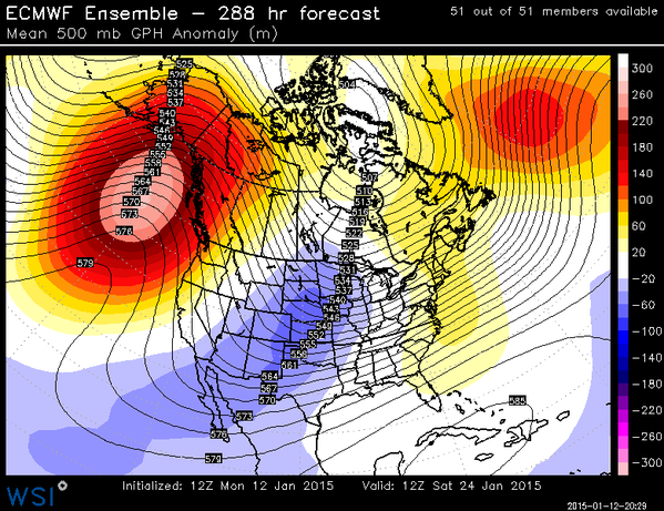
While there's pretty high confidence in the thaw, there are also strong indications of a return to big winter cold for the end of January. The latest ECMWF ensemble data and weeklies all point to a very potent ridge building back up across the West Coast, western Canada, and Alaska. This helps open the door to cross-polar flow again, and may drive temperatures will below average to end out January and start February. This is the same pattern we've seen a few times this winter, with the heart of the cold over the middle of the nation, but well below average temps still filtering their way east of that epicenter.
Unfortunately for snow lovers, it also doesn't depict a very friendly setup for snowstorms. Yet again, there's no blocking over the North Atlantic to cage the cold and stormy weather in. The strong highs are pushing in from the west, and so they are providing the cold but moving any storm formation away from us. This may be another round of bitter cold without a storm, but of course we're talking about possibilities two weeks in advance. Some things can always change. To date though, we know it's been a barren winter. Plenty of rain, plenty of cold in recent times, but WAY below average snowfall. Indeed our seasonal forecast is in big trouble at this point in regards to snow. With nothing coming in the next 7-14 days, we're down to February and March to really provide. And even then, we'll need to go on a tear. It's happened in the past but the odds are certainly increasing in favor of below average snowfall in southern New England this year. A comeback miracle in the works or a complete dud? We shall see when the spring breezes start blowing...