Tracking The Winds Of Winter
Find Eric Fisher on Twitter and Facebook
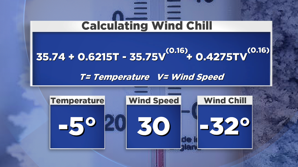
Believe it or not, we receive feedback from people that think we're making up wind chill as a marketing tool. It's a real equation folks, I promise. It's automatically calculated and generated on our maps using this equation developed by the National Weather Service.
By now I'm sure you've heard that it's going to get awfully cold out. I suppose you could say it already is! Highs stayed in the 10s on Tuesday, which made it the coldest day in our area since January of 2014. It's the coldest time of the year, and it's living up to its reputation. Boston was just 1 degree away from a record 'low maximum' (coldest high temp on record) for the date. But without too much wind? Manageable. Unfortunately, the next few days won't feature the relative calm of Tuesday.
Wednesday - Tracking The Arctic Front
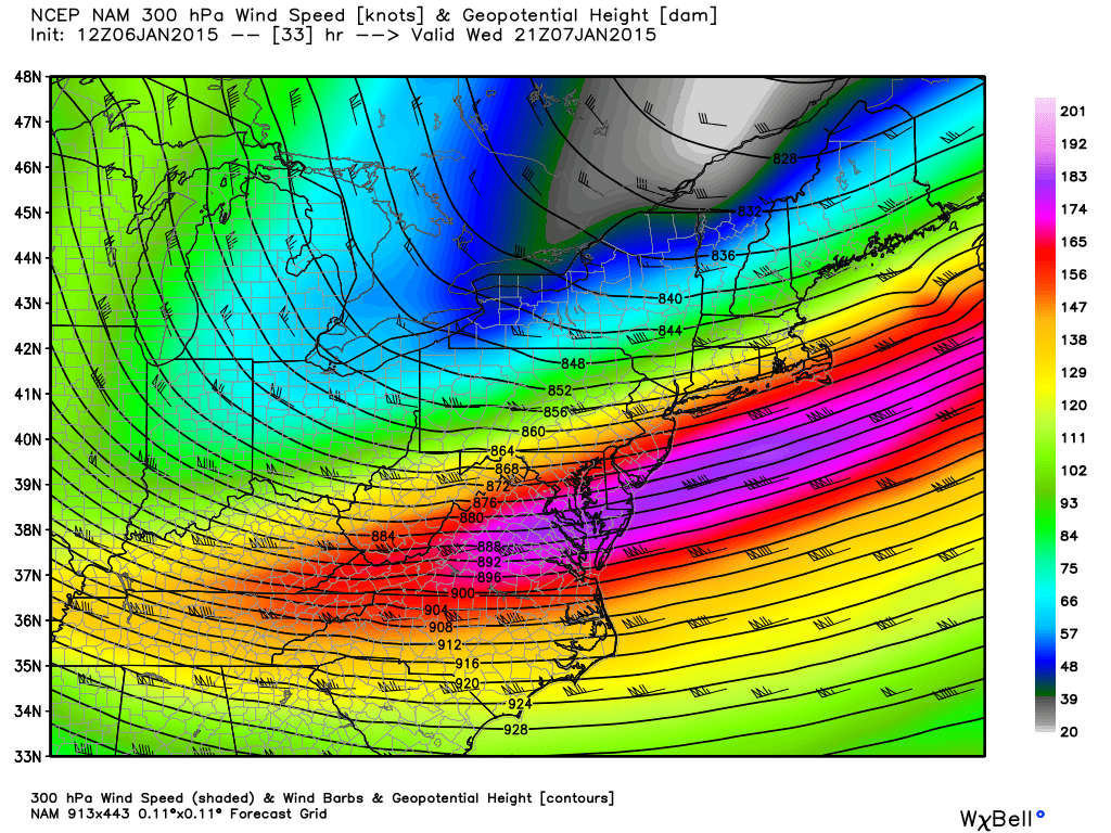
Got tailwind? Jet stream will be ripping east at about 210mph on Wednesday off the East Coast. Source: Weatherbell
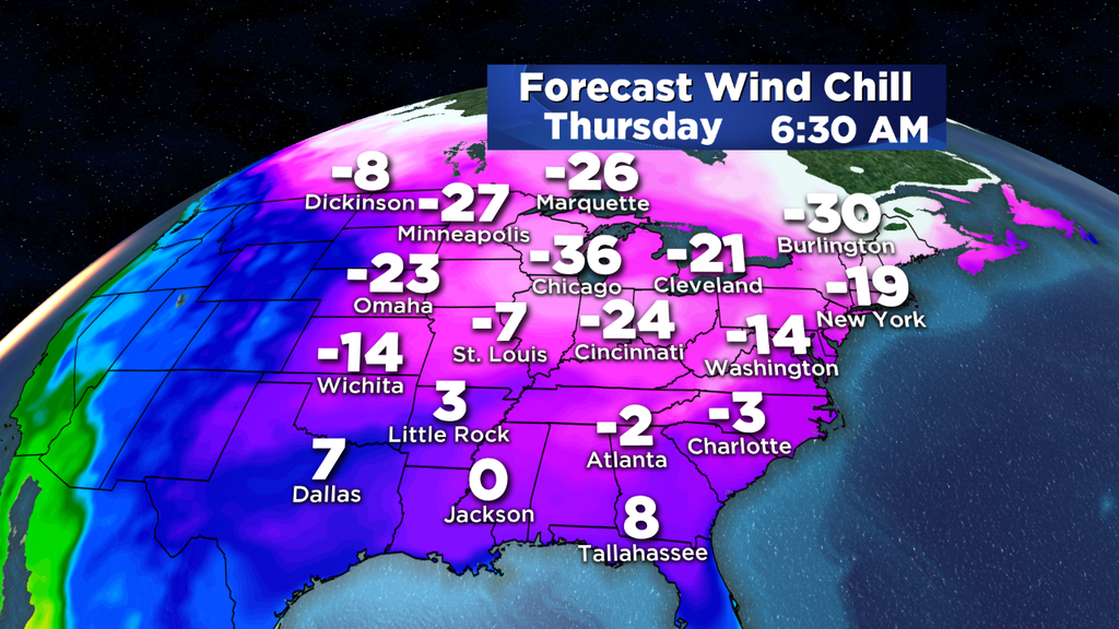
There may be a little breeze around to start the day, but winds will start increasing with 20-25mph gusts by midday. The strongest winds will pick up behind the arctic front from mid-afternoon through Wednesday night. Gusts out of the NW should reach 35-40mph across the area. Combine that with temps falling into the 10s during the afternoon, then 0s by late evening, and subzero at night...and you've got a recipe for some truly nasty and dangerous cold. We only see a couple days per winter that really test the -30F wind chill threshold here in SNE, and Wednesday night/Thursday morning should be one of those times. We haven't really had to deal with it so far this winter but you know the drill. MANY layers if you have to go outside, put a tight limit on how long your pets are outdoors, and have that automatic car starter handy if you're lucky enough to have one! Exposed skin can give way to frostbite in about 30 minutes with wind chills like that.
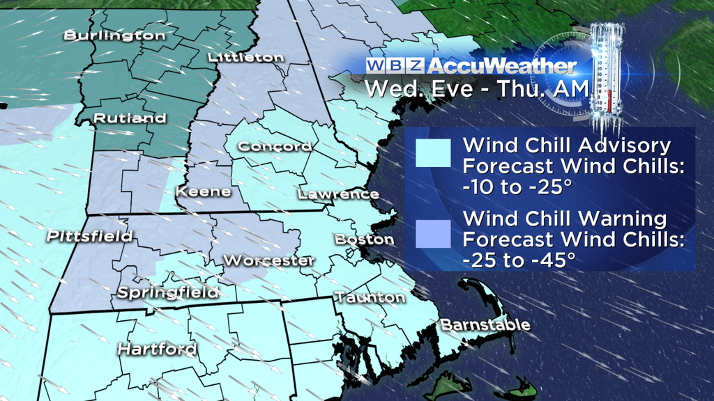
The strongest winds will be across the higher terrain, and that's also where the coldest temps will be. Wind chill values above 500' in central/western MA and the higher elevations of Vermont & New Hampshire may reach the -30F to -45F range. Goes without saying - don't go outside if you don't have to!
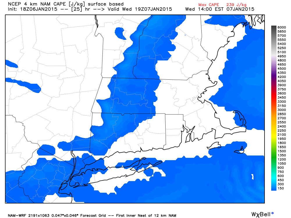
WRF shows a ribbon of CAPE forming Wednesday afternoon along the front. Temps coming in aloft are so cold that steep lapse rates are generated, which help to squeeze out the meager moisture we'll have in place. The result? Squalls, and maybe even a crack of thunder! Source: Weatherbell
Also on the watch for snow squalls midday through the early evening across the region. Instability should be generated by extremely cold air aloft, and there's just enough moisture to generate these squalls. Sometimes they just don't materialize, which is a possibility. But if they do swing through you can find yourself in brief whiteout conditions with strong winds and heavy snow...with a quick coating to a couple inches coming down. The biggest impact from squalls like these is typically on those driving, so be wary of changing conditions Noon-6pm.
Thursday - Coldest AM in years?
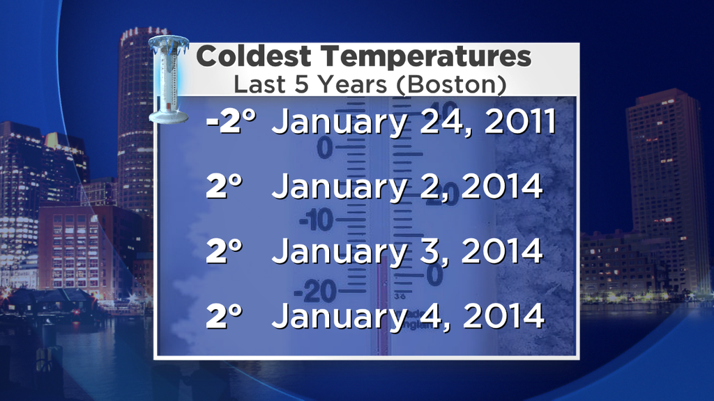
As discussed on the previous blog - Boston just doesn't hit (or drop below) 0F very often. It's only happened twice in the past 10 years, but we may have a shot Thursday morning. I'm still forecasting a low temp of 0F, which would make it the coldest temp in the city since January of 2011. We'll see where it ends up! In any case, it certainly won't be any fun outside.
In terms of wind, we're talking gusts 20-35mph on Thursday. With temps topping out in the 10s, it's going to be another frigid day with wind chill values mainly staying below zero. Not as fierce as Wednesday night, but follow the same advice of covering up and limiting time outdoors if you can.
Friday - Sneaky strong winds
An interesting setup on Friday as a disturbance rotates across the Northeast with a lot of wind energy. Wind speeds off the deck (850mb) are expected to be in the 60-70 knot range. In many of our winter events, those strong winds are tucked away in a warmer layer of air above the surface and have a tough time mixing down. But in this instance, it'll be wind coming across water that's in the 40s, and the air aloft will still be quite cold. Thus, no significant inversion to overcome.
All those things said, there's the potential for damaging southwesterly winds gusts on Friday for SE Mass. Some may reach the 50-60mph range, and the trajectory off the water will push temps there into the 40s! Winds will still be strong in the interior, but not reaching those levels (more in the 35-45mph gust range). We'll have to keep a close eye on this situation as we get a little closer. Temps in the interior may briefly bump up near the freezing mark, but another shot of cold moves in by Friday evening.
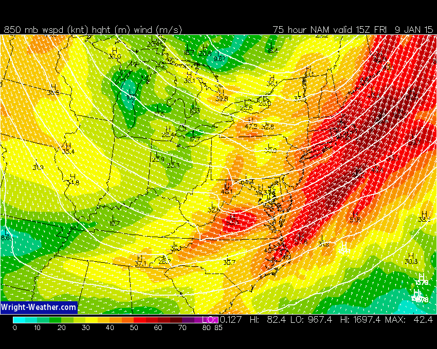
NAM forecast winds on Friday morning at 850mb. These strong winds should be able to mix down to the surface at times. Source: Wright-Weather.com
To go along with this system there should be scattered snow showers/squalls, which could put down a coating to a couple inches of snow (especially from Boston north/west). If you're traveling up toward ski country the snow squalls should be more vigorous, so keep in mind that driving conditions could deteriorate rapidly from time to time.
Saturday - Yup, still cold
Yes, we'll be stuck in the 20s again. Yes, it will still be breezy (some gusts around 25mph look likely). BUT there is some good news - the core of this cold shot misses us to the north. It looks like the brunt of truly bone-chattering cold will stay just a few miles north of the border with Canada. So we've got that going for us. Which is nice. Expecting low 20s for the Patriots with wind chill in the 10s and 0s...but it'll be dry and not windy enough to cause trouble for the passing game. Go Pats!
Temps moderate a bit on Sunday with less wind, and a wave of low pressure to the south may keep us gray and chilly into Tuesday and Wednesday. There may also be some areas of snow to keep an eye on, but it's a little too early to tell how far north that wave is going to track. I'm willing to bet it'll stay suppressed to the south at this point, but we'll see.


