Hope Santa Brings You Shorts This Year
Find Eric Fisher on Twitter and Facebook
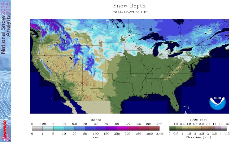
Lower 48 snow cover, as analyzed by the NOHRSC, is at 27.7%. That's the lowest value on 12/23 in the past 10 years. It was 33.2% on Thanksgiving Day!
Bing Crosby would be pretty depressed with this forecast, and frosty has booked his trip to the Yukon to spend the holiday. There's zero shot at a White Christmas in southern New England as an unusually warm storm pulls plenty of mild and, UGH, humid weather up the East Coast. Granted, I know there are many of you who are doing backflips over this and hope this kind of weather will last all winter. For you, I am happy. For the winter traditionalists, I am most certainly not.
Check: Current Conditions | Interactive Radar | WBZ Weather Blog
Timeline:
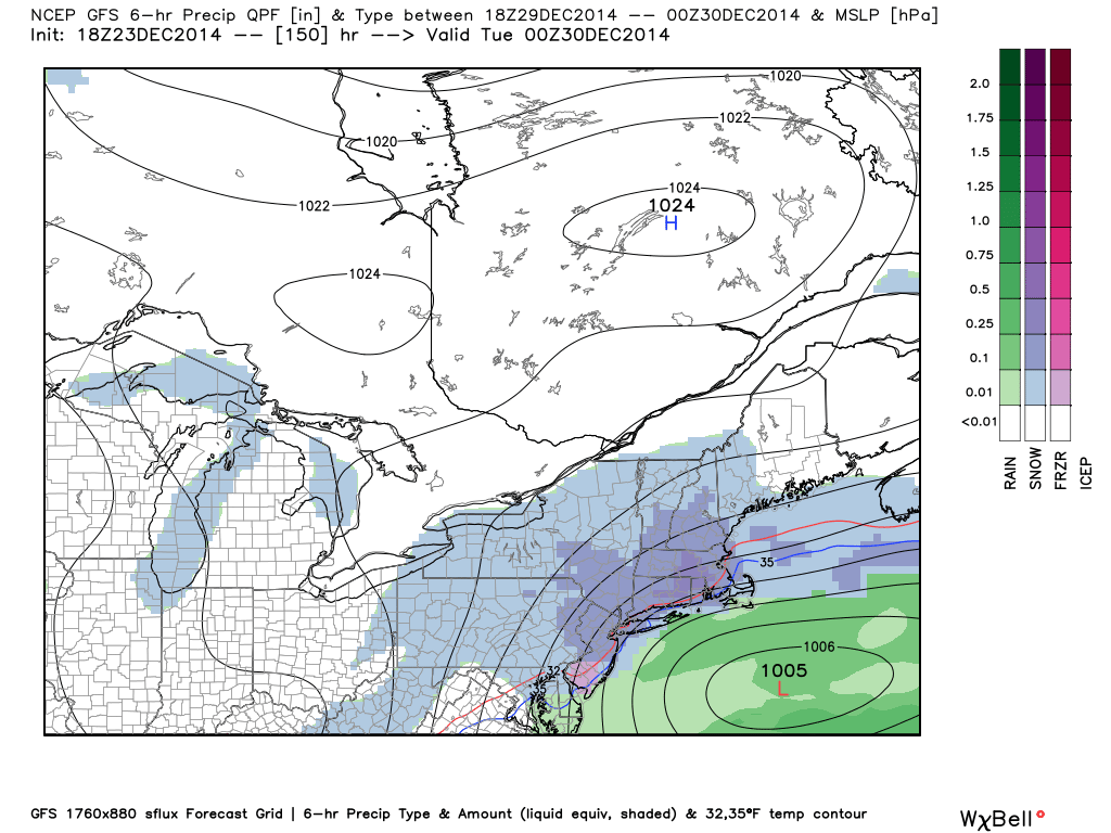
If you want to get some errands done, buy that last minute gift, or hit the highways - the first half of Wednesday is a good bet. There will be areas of fog around to be sure with a murky morning expected, and some drizzle as well. But the steadier and heavier rain shouldn't get going until the afternoon and evening. I know I plan on a morning run outside to (irrationally) make myself feel better about eating 5 pounds of Christmas cookies afterward.
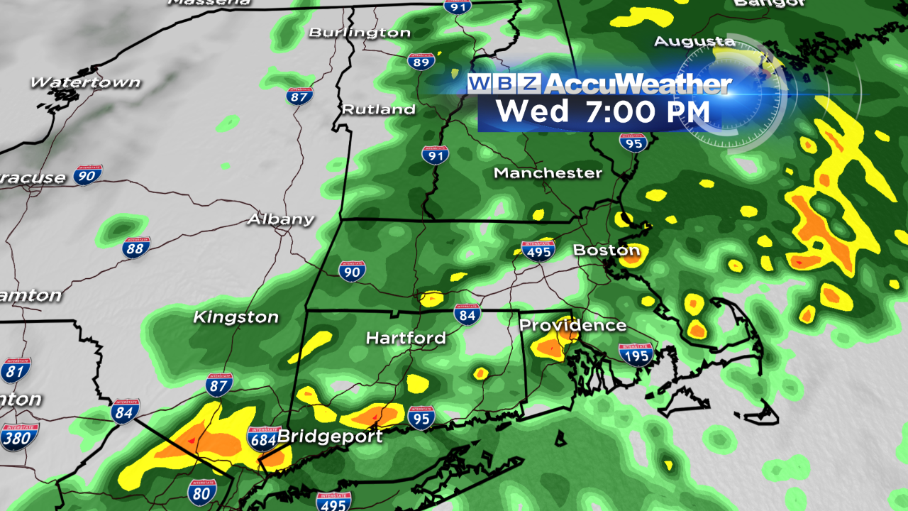
Areas of rain will become more organized heading into the afternoon, with some downpours mixed in and climbing temperatures. For all your Christmas Eve plans - make sure to have some rain gear handy and the presents well covered up to keep them dry. The wind will start to swing around to the south too and become gusty, although the stronger winds will be yet to come.
Areas of rain and downpours continue through the night and into Christmas morning before winding down. Believe it or not, there could actually be some claps of thunder and flashes of lightning to go along with this. Not exactly standard Christmas fare. Rain should start wrapping up between 7a and 10a from west to east, leaving the Cape by late morning.
Temperatures:
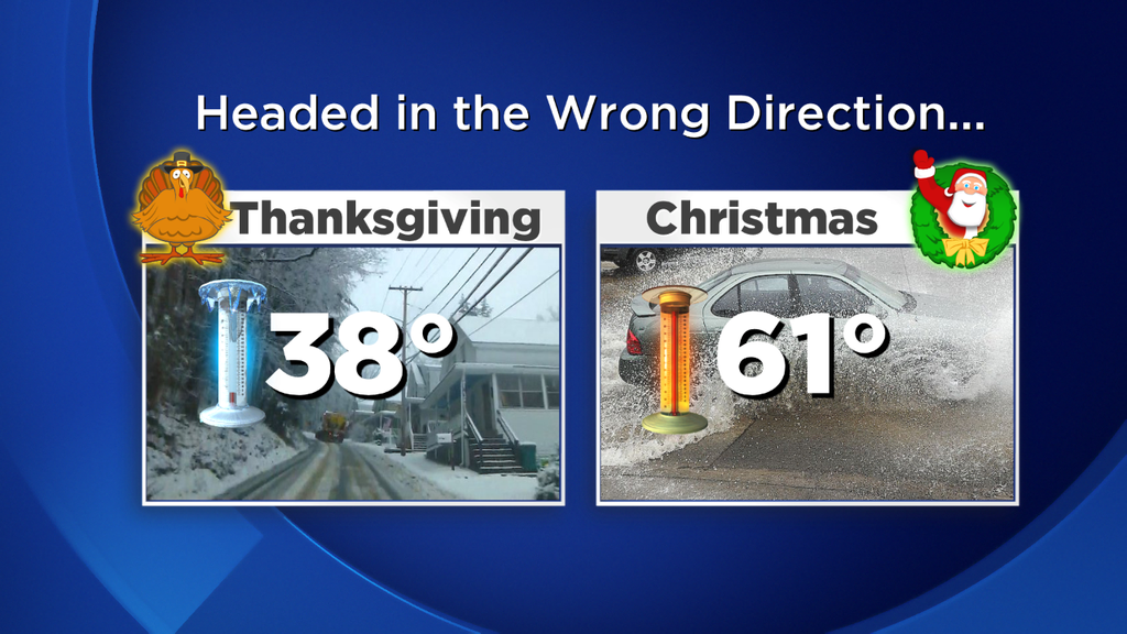
Wow. With a side of gross. This should easily be one of the warmest Christmas Days we've ever seen here in the Boston area. In fact, I'm expecting it to be warmer than Thanksgiving (38F in Boston) was, Halloween (54F) or Easter (48F). It'll even be close to Memorial Day Weekend when we were in the 60s Saturday and Sunday. Santa will have the top down on the sleigh no doubt.
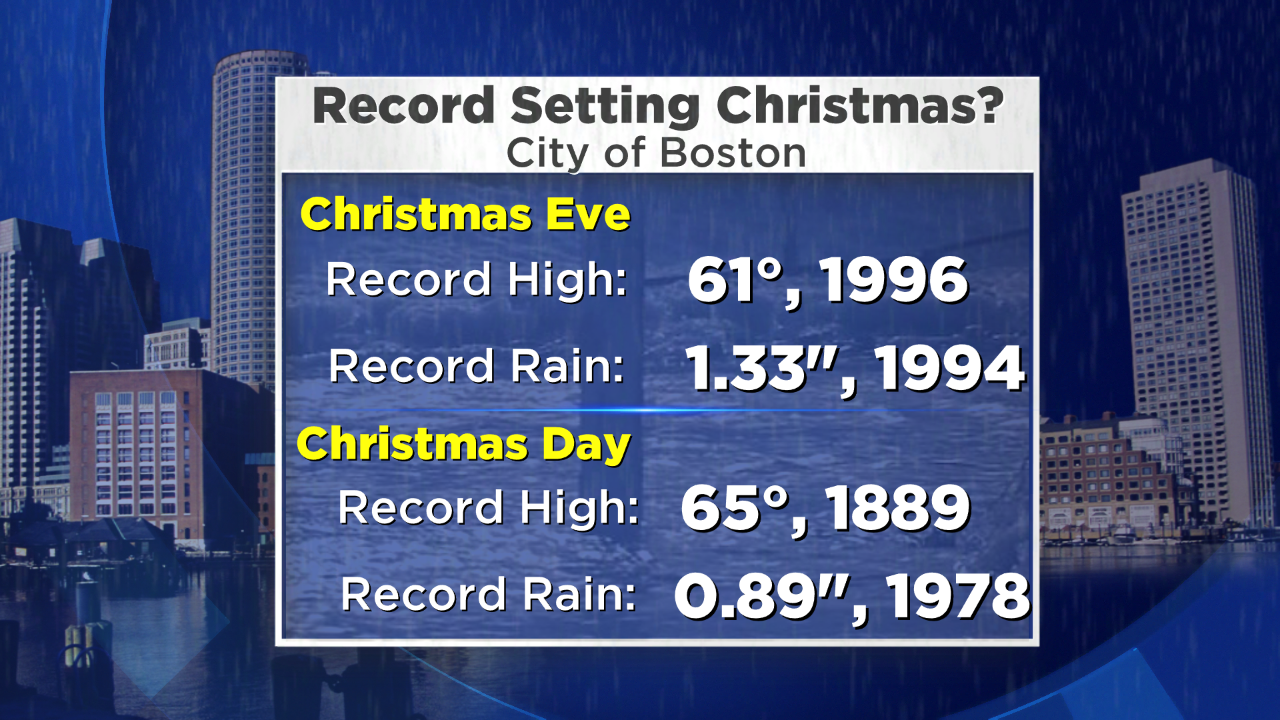
We'll be climbing into the 50s Christmas Eve, with a chance of reaching the record high of 61F for the date by 11:59pm. Our high temp for the 24th will likely be in those final minutes before we flip the page to the next day. There's an *outside* shot we hit 65F in Boston on Christmas morning, which would be good enough for a tie for warmest Christmas on record (one that dates back to the 1880s!). No matter what, if we top 60F it'll be rare air. Not only will it be warm, but HUMID. I mean....c'mon! Dew points should climb to near 60...and it'll definitely feel muggy Wed PM through early Thursday morning.

I'd say dew points like these are very efficient at eating up a snowpack, but...uh...there's no snow. Source: Weatherbell
Winds:
While it should get gusty Wednesday PM, there are really two times that we'll be keeping an eye out for strong winds. One will be in any downpours that develop in the overnight/early Thursday. There will be a very strong inversion in place (850mb temps near +12C!) so the only real chance of getting stronger winds aloft down to the surface will be with these storms...or if we can really get the surface to warm into the mid 60s. Gusts 30-50mph are possible Wednesday night into Thursday morning with this.
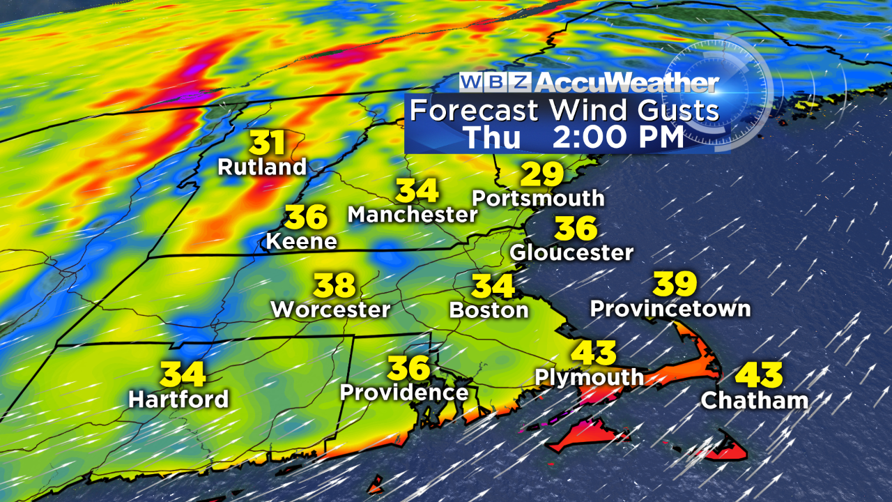
But the most widespread winds will actually be as the storm passes and we begin to dry out on Christmas Day. There will be plenty of wind energy swinging through, so area-wide gusts 30-50mph out of the west are possible. This could also lead to some scattered power outages and spotty damage. Keep in the back of your mind that the lights going out for a while may be in the cards for your Christmas Day plans.
The Deluge Continues:
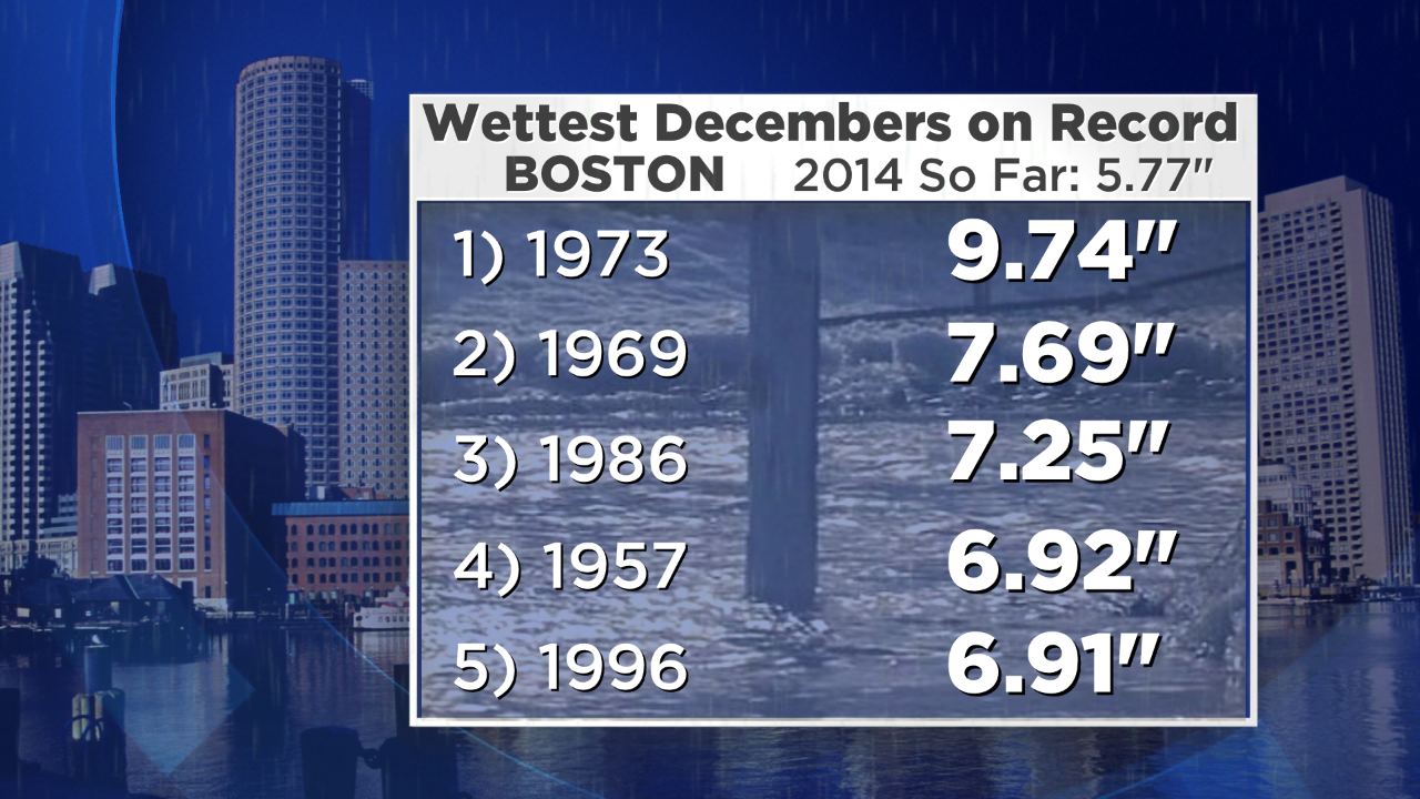
Rain? Yeah, we've got that. What a month of December. The forecast for a very stormy pattern has been spot on - but the snow part has not. We've already had over 5.5" of precipitation in Boston this month, and should see another 1-2" before this one wraps up Thursday morning. That would assure it a spot in the Top 5 wettest Decembers ever recorded. If we can get to 2" of rain, it'll head into the #2 spot. There still another shot or two for storminess before the month ends so I feel like at least #2 all-time is going to be likely.
The inevitable question - how much snow would that be?! Well if we end the month with, say, 8" of total precipitation - that could equate to somewhere in the area of 6 or 7 feet of snow. If you're a snow lover, that's a whole lot of wasted precipitation.
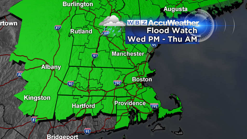
With the expected 1-2" of rain, there could be some minor flooding issues. A Flood Watch has been issued for all of the area for Wednesday afternoon through Christmas morning. The type we're looking at is for some of the typical nuisance flooding that comes along with downpours. When it rains heavily, there will be standing water around and some very slow travel. Not expecting anything more than that locally. To the north, the rain will come along with melting snow. They've been hammered with snow over the past month and so rivers and streams rising will be a larger threat in those locales.
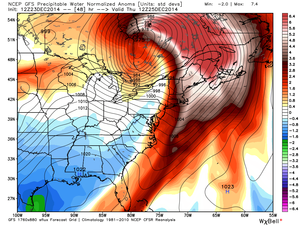
Precipitable water values a whopping +6 SDs vs average for Canada! And yes, that's rain hundreds of miles north of the border. Source: Weatherbell
The Winter Outlook - What Gives?
Well it's pretty clear to see the winter outlook isn't off to a roaring start. We figured the month would start out milder, but I'm pretty surprised to see how much staying power the milder air has had this month. The storms have been coming, but all the snow has been 100 miles north of us (near record levels of it). It's not time to call 'game over' on winter of course, but it hasn't been off to the expected colder start.
So when do we start to worry (if you do indeed worry about seeing less snow and cold)? I'd say by mid-January. There have been plenty of years where we've had very little until MLK Day, and then caught up in a big hurry. It's pretty easy for January and February to produce 50" of snow if we can get some colder air in place and keep the storms coming. In general, our biggest storms come from mid-January through March. So time will tell if we see a boom, or this forecast goes bust.
There are some chances for snow in the relatively near term. It's certainly no solid bet at this point, but models are hinting at some mix moving through late Sunday into Monday. There's support from the GFS, as well as ECMWF and ensembles. Doesn't look like a big one but a chance to at least start adding to our snow totals for the season, especially across the interior.
The overall pattern looks colder (although not frigid like last year) heading into the New Year, and there have even been hints of an early January snowstorm. Confidence is not high on that at this point, but some colder air should at least point us in the right direction. Nothing to do but wait, see what happens, and deal with what nature hands us!
On a final note - a VERY Merry Christmas to all of you. Thank you for being WBZ viewers and readers of this blog. I hope you have a wonderful holiday season, even if you can't use the new snowshoes or jackets just yet. Travel safely, have fun with friends and family, and enjoy all the season has to offer.
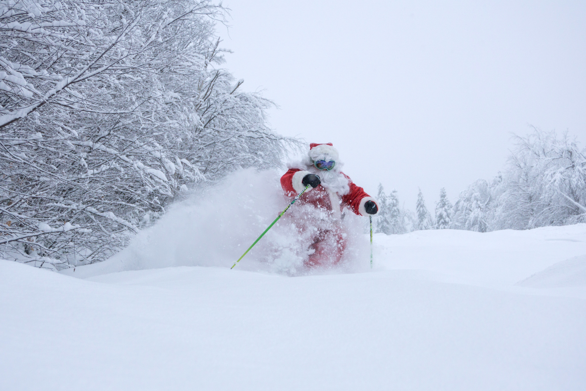
Santa knows the forecast stinks, so he got his turns in on Tuesday at Sunday River in Maine. Courtesy: Sunday River
MORE LOCAL NEWS FROM CBS BOSTON