Wheel Of Misfortune
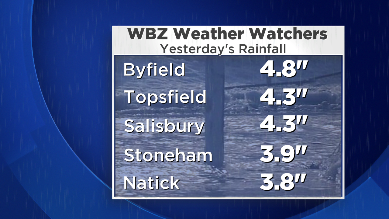
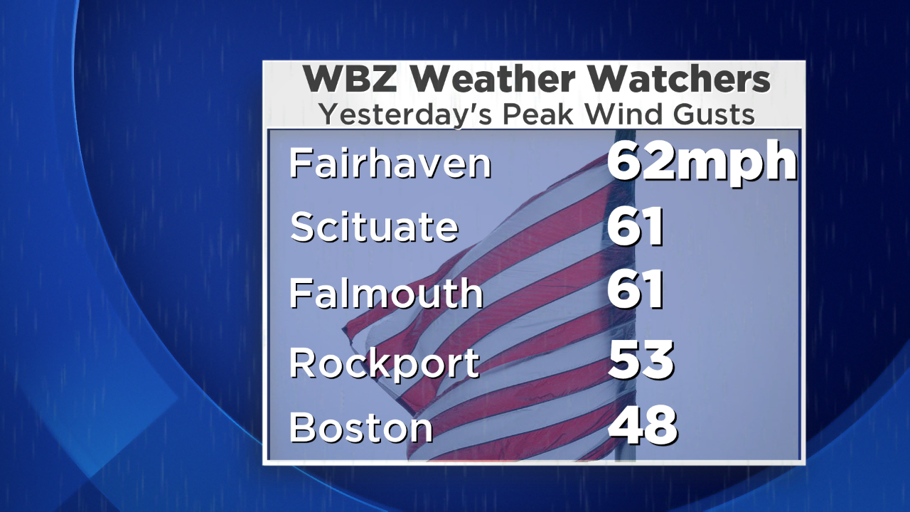
As bone-chilling as it was Monday with temperatures struggling to reach the 20s, we were very confidently predicting that the nor'easter would create a robust rain event. It even exceeded expectations in northeastern MA where 4-5" amounts were common. With the top layer of soil frozen, the rain could not seep into the ground many areas so it exacerbated the flooding of basements, roadways and other poor drainage locations. Streams were overflowing but the main rivers are within their banks. Flood waters have receded most areas this morning and nothing more than some mist and patches of light rain will be migrating across the region today. Fortunately, we are not dealing with any icing issues this morning like yesterday thanks to the scouring out of the cold freezing air. While some of the northern mountains received several inches to a foot or so of wet snow, it was a somewhat disappointing amount in places but there will be more snow falling there before this system exits late in the week. The storm has decayed significantly and its center is wobbling over coastal MA this morning. It is trapped underneath a closed upper level low pressure system so we'll be playing wheel of misfortune for the next several days!
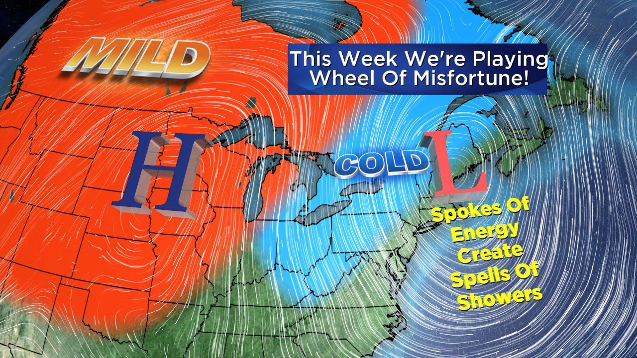 Spokes of energy will be pinwheeling around this circulation and creating spells of showers today through Saturday. As the air aloft becomes colder, some of the rain showers may become mixed with or change to snow showers in places especially from the Berkshires eastward into the Worcester Hills. Some small accumulations cannot be ruled out in those spots. I wouldn't be surprised to see some snow showers visit eastern MA as well in the next few days. There is a chance of some brief brightening episodes with peeks of sunshine primarily over southeastern MA in the days ahead. The block will finally break down and shift offshore over the weekend so sunnier times will set in on Sunday and Monday. Expect daytime highs in the upper 30s to lower 40s and overnight lows eventually cooling back to the upper 20s to lower 30s as the week progresses.
Meantime, a flow of much milder air is streaming across western Canada with temperatures way above zero which is a switch from the frigid weather that occurred during most of November. The mild air is also warming much of our nation west of the Ohio Valley. This will be a temporary break as it appears that the set of dominant global factors favors a recharging of very cold air in Canada again late next week with below to much below average temperatures probable in January with an expansion into the nation from at least the Upper Mississippi Valley eastward across the Great Lakes into the Northeast.
On WBZ News, you can watch the weathercasts presented by Danielle Niles through 9 o'clock this morning and again at noon and I shall return for the evening shows for Eric Fisher.
Make it a great day!


