Eye On Weather: 2015 Winter Forecast
BOSTON (CBS) - We all have a curiosity about the future and, understandably, most people wonder what the impending winter is going to be like more than any other season of the year.
Read: Eye On Weather Special Reports
Winter, after all, can be very challenging for everyone including us meteorologists. The chaotic nature of the fluid atmosphere makes even short-term prediction tricky business so for a long time to come, that will probably limit our ability to specifically forecast the weather with any high degree of confidence beyond a theoretical threshold of 7-10 days.
It really is a complex science of gargantuan proportions. Seasonal forecasting has become more intriguing over the years as we gain a greater understanding of the amazing connectivity between the oceans and the atmosphere. They are reactionary and their cycles and oscillations yield different sets of global factors that create our varying weather trends.
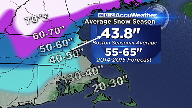
Last November on our "Eye On Weather: A Winter Preview" special, we predicted near to above average snowfall across our region specifically forecasting from 50-60 inches in Boston. The city's total was 58.9 inches.
We also expected widespread intense cold over the central and eastern portion of the nation with near to below average temperatures in New England. The only surprise was the magnitude of the chill in March when Boston's mean temperature for the month was a whopping 4.8 degrees below average. While this extended strengthening cold following several snow events February made it seem like the never-ending winter, it wasn't even close to being historical!
So what's up for this winter?
Based upon the present and predicted indices of the various global climate factors and considering their analog years, the WBZ-TV AccuWeather Team presently projects an overall winter delivering:
1. Above Average Snowfall
Prediction of seasonal snowfall is much more difficult than prediction of temperature trends.
Forecasting each and every snow event is a challenge due to precise storm path and associated temperature swings so a seasonal prognostication can easily be fraught with error if several storms hit or miss. The recent snowfall especially over the interior is not necessarily a clue of a snowy winter. Statistics reveal that early snows in October tend to lead to less snowy winters but snow in November can go either way so the winter outlook depends upon other key ingredients.
Most global factors this fall do indicate another robust snow season ahead as North Atlantic blocking will be more of a player. Last winter, blocking was negligible resulting in no blockbuster storms. There were several systems but they were all progressive and moved out quickly. With blocking in play especially later this January and February, bigger storms are a threat. A couple of factors hint that more aggressive blocking may steer storms on a more southerly route across the Mid-Atlantic region. So there are some conflicting cross currents here.
Nevertheless, we feel that with potential phasing episodes of the polar and subtropical jet streams, some nor'easters will be in the works.
Consequently, we are projecting snowfall as much as 10-20" above the average for much of the region. This equates to a range of 55-65 inches in Boston.
If that verifies, it would be the third consecutive year of above average snowfall and that has not happened since the winters of 1975-76 (46.6"), 1976-77 (58.5") and 1977-78 (85.1").
Additionally, it would be the 4th out of the last 5 years with above average snowfall. The previous occurrence of this was in 1992-93 (83.9"), 1993-94 (96.3"), 1994-95 (14.9"), 1995-96 (107.6") and 1996-97 (51.9").
2. Below To Much Below Average Temperatures
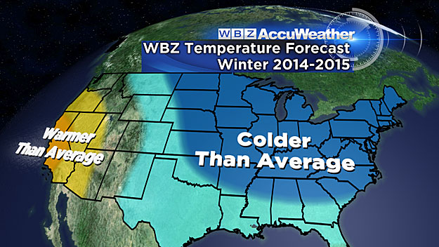
The nation has already been shivering thanks to the anomalous cold during the month of November.
For instance, Minneapolis had 50 days below zero last winter and has already endured 12 consecutive sub-freezing days making it the longest November stretch in 134 years! The frozen fickle finger of fate was placed over the Upper Plains, Upper Mississippi Valley and Great Lakes last winter where arctic blasts were frequent. It is possible that this core of cold will be shifting farther east closer to the Northeast this winter.
While we recently experienced 3 warm days, 10 back to back below average temperature days occurred before that and we are right back to bad habits now. That doesn't mean that every day going forward will have below average temperatures. There are some signals that we will experience temperature fluctuations bouncing back and forth between mild and cold in December with a trend to colder than average later in the month setting up for January being the coldest month of the winter. One of the analog winters is 2003-04 which produced an extremely cold January in the Northeast as Boston endured several record low temperatures having 11 days below 10 degrees with the lowest at 7 below zero! It was the city's 5th coldest month ever behind February 1885, January 1888, January 1875 and February 1934.
We are not anticipating it to be quite that severe but the stage is primed for some outbreaks of arctic air during January. Based upon the present and projected alignment of global factors, we are anticipating an easing of the cold in February but the month, overall, will end up with a mean temperature below average.
The encouraging news is the potential that March 2015 will be much different from March 2014. The pattern change should be unfolding at that point which would favor temperatures going above average.
The accuracy of seasonal weather prediction has improved significantly over the years thanks to the work of brilliant scientists in and out of the government sector. They have identified a myriad of global factors that influence seasonal climate forecasting for various locations. These include ENSO, the NAO, the QBO, the PDO, the PNA, the EPO, the TNA, the AMO, the MJO, etc.
The permutations in the phases of these numerous oscillations, the solar cycle, geomagnetic activity, recent volcanism, storm track data, fall temperature and precipitation patterns plus the extent of snow cover from Eurasia into western Canada and the ice coverage in the Arctic sea all play a role. It is a veritable Rubik's cube and the finesse is figuring out all of its intricate twists and turns.
If you desire a more detailed and technical analysis, read this paragraph and the next one or just skip to the final concluding remarks.
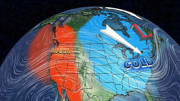
So we have been closely following a pool of warm water in the northeast Pacific Ocean which was located closer to Hawaii about three years ago. It migrated northward and ended up in the Gulf of Alaska last year and it has been gradually shifting east from there into the extreme eastern Pacific. This was one of the big players last winter that was responsible for pumping up a strong ridge aloft which tapped and released plentiful arctic air downstream across Canada and into the United States. A similar warm pool was positioned in the northeast Pacific Ocean in 1916-1918. Those two winters were both very cold across much of the country and as the warm pool shifted east, the core of the cold moved east as well. These warm pools usually last a couple of years and that is exactly what happened in 1918-19 as the warm pool dissipated leading to a warm winter. We think there are signs that the warm pool this year will be fading late this winter and that is one reason why we believe that March 2015 will be much milder than March 2014. The water in the northeast Pacific Ocean was even warmer than last year but it is leveling off now which may be a signal of cooling and dissipation late this winter and spring. Another clue to a cold winter is the rate of snow cover change over Eurasia and northern North America in October and November. The greater this change in October, the greater the impact on winter temperatures across the U.S. This October, there were well over a million more square kilometers of snow coverage over last October.
Another dominant player this winter is the QBO which is a slow oscillation in the strength and direction of the zonal wind in the lower and middle stratosphere over the equator. It has a period of 28-29 months. This winter that zonal wind is blowing from the east over the deep stratosphere and analog winters had Boston snowfalls in the range of 35-65". The lower range amounts of 35-40" in such winters as 2003-04 and 2009-10 were likely due to storms curving out to sea south of New England which can be a characteristic of easterly QBO years. Regardless of the phases of ENSO, the AMO, the PDO and solar input, Eurasian cold and widespread U.S. cold is quite typical in easterly QBO winters as the AO kicks in yielding building air pressure over the arctic and subsequent high latitude blocking and warming. This actually weakens the polar vortex and there is a suppression of the jet stream and its cold stormy weather southward through Canada into the U.S. ENSO is currently in the neutral state with warm water stretched across most of the equatorial Pacific Ocean. However, there is a possibility of a weak Modoki El Nino developing. This means that the sea surface temperatures will become warmest in the central rather than eastern equatorial Pacific Ocean. All of these contributors portend a western North America ridge with a weak subtropical jet stream. Add to the above a low solar input and a low geomagnetic index and you have a slew of factors that favor Davis Strait/Greenland blocking. Sudden stratospheric warmings are linked with easterly QBOs and also linked to the AO/NAO. It tends to generate the negative phase of both which lead us to anticipate a very cold January followed by blocking and jet stream phasing primarily later in January and February. The presence of a pool of cold water in the northeast Atlantic off the UK favors blocking and that was missing last year. Anyway, the phase of the NAO is a major wild card every year regardless of other dominating factors. Seemingly, other factors this fall and winter support a negative NAO much more than last year so that is another reason for the above average snowfall prediction.
3. Conclusion
In conclusion, the signals are flashing a rather harsh winter.
There is always a risk of a shocking surprise that trumps all contributing factors such as the 2001-02 non-winter when suddenly the solar flux spiked sharply which shrunk the polar vortex resulting in a zonal flow of mild air from the Pacific eastward across southern Canada and the U.S.
Perhaps you would like another easy winter like the recent one in 2011-12 when Boston received only 9.3" of snow and the monthly mean temperatures were all more than a whopping 5 degrees above average!
November 2011 was the second warmest November on record plus the fact that the north Pacific sea surface water was cold were clues that the winter was going to be a wide open season for sure.
We are relatively confident of a cold and snowy winter overall. The magnitude of both of those variables remains a bit vague but we are highly confident that it will not be easy.
The cast of characters is large and we will be watching closely for any twists in the plot.
For many years, the WBZ AccuWeather Team has learned a great deal about the global climate and seasonal forecasting and its variability by following the highly respected meteorologists, Joe D'Aleo and Joe Bastardi.
Their extensive research and knowledge of this complex field is nothing short of extraordinary. We thank them for their commitment and guidance.
You can follow their work and findings on WeatherBell.
For more fascinating information on climate change, visit Icecap.
Finally, through the end of this December, you can enter the WBZ Snowfall Contest and guess the amount of snow that will fall at Boston's Logan Airport during the period of October 1, 2014-April 30, 2015.
The winner receives a season pass to Mt. Wachusett for the 2015-16 season plus a new Toro snow blower!
Good Luck!
With 100-percent certainty, astronomical winter begins with the solstice at 6:03 p.m. on December 21st.
Have a great winter!
Follow Barry on Twitter @BarryWBZ
MORE LOCAL NEWS FROM CBS BOSTON

