Thanksgiving Travel Snow Storm: What You Can Expect
BOSTON (CBS) - Our Thanksgiving Eve storm is on schedule, rain and snow are here.
However, there are a few minor changes to the track which could have major consequences to the final snow totals.
Check: Interactive Radar | Weather Blog | Current Conditions | Share Photos
We started seeing this Tuesday. The storm is likely to track about 50 miles or so closer to our coastline.
Download: CBS Boston Weather App
This, in turn, will allow for a layer of "mild" air to work in at about 10,000 feet up in the atmosphere this afternoon. When I say mild, it is going to be near or slightly above 32 degrees, just enough to change the snow to sleet for a few hours and throw a monkey wrench into projected snow totals north and west of Boston.
TIMELINE
So given this scenario, lets break this storm down one last time, hour-by-hour.
Noon-to-4 p.m:
Rain and snow become heavy. Initially the rain will change to snow in the 495 belt and perhaps as far east as Route 128.
The atmosphere will be very "borderline" though in this time frame in the nearby Boston suburbs. Snow may mix with and change back to rain, flip-flopping at times.
That warm layer enters at high levels, creating some sleet from 128 to 495 and as far north west as about Lawrence to Worcester.
Snow continues in northern Worcester County, southwest New Hampshire and all areas farther northwest. Roads start to whiten in towns like Fitchburg, Ashby and Orange and a few inches of snow accumulates on grass there as well.
4 p.m.-to-10 p.m:
Heaviest precipitation occurs in this time period and the majority of the snow accumulation happens now. The warm layer retreats and the sleet changes back over to snow north and west of Boston.
As it gets dark, more and more roads get messy and snow covered. Snow will continue to accumulate readily north and west of 495.
Between 128 and 495, it will take longer for snow to stick, most main roads will stay mainly wet, not white.
Right at the coast, from Cape Ann to Boston and the South Shore, some wet flakes will mix in with the rain between 8 and 10 p.m.
10 p.m.-to-4 a.m:
The heaviest precipitation is gone, but light to moderate rain and snow continue.
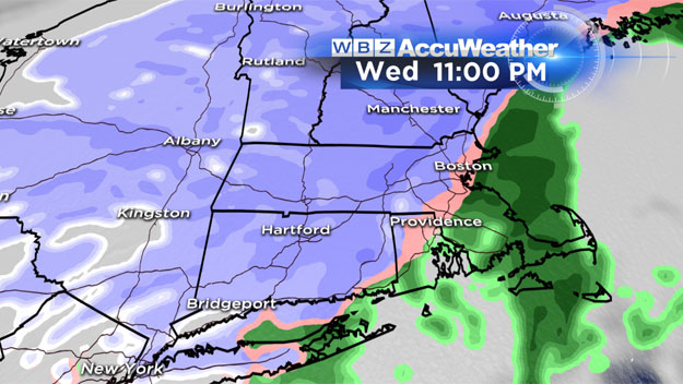
As the winds shift to a more northerly direction, rain will change to snow along the coastline all the way down to Cape Cod Canal. This could leave a coating to a slushy inch in the city of Boston and parts of southeast Massachusetts.
HOW MUCH SNOW?
All snow: north and west of a line from Hartford to Worcester to Manchester, NH: 6-to-10 inches, with a few higher amounts locally.
Mix of rain sleet and snow: 495 belt (northwest of Boston) to Worcester and Manchester NH: 3-to-6 inches.
Mainly rain/sleet to snow late: 128 belt, interior southeastern Mass: 1-to-3 inches.
Heavy rain, ending as wet snow: Immediate coastline, Cape Ann, Boston, South Shore: Slushy coating to an inch or so.
All rain: Cape Cod, Islands
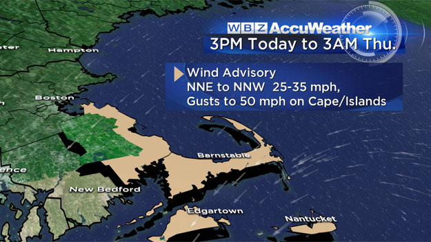
WINDS
An area of concern for strong, potentially damaging winds is the coastline of southern Plymouth County, Cape Cod and the Islands. Gusts to 50 mph are likely here between 4 p.m. and midnight.
COASTAL FLOODING:
Not a concern with this event. We are watching the high tide after midnight for minor flooding and erosion.

Follow Terry on Twitter @TerryWBZ
MORE LOCAL NEWS FROM CBS BOSTON