Snow Storm To Make Absolute Mess Of Holiday Travel
BOSTON (CBS) - The first significant winter storm of the season is on its way, set to make an absolute mess of holiday travel up and down the East Coast.
For many, the timing couldn't be worse.
Check: Latest Forecast Maps
The day before Thanksgiving, when the majority of schools have a half-day, many workers try to slip out a few hours early, and millions are on the roads trying to get to their ultimate Turkey destination.
Check: Interactive Radar | Weather Blog | Current Conditions | Share Photos
The major hubs all along the East Coast will be buzzing with activity and all of them will be severely impacted by this untimely coastal storm.
Download: CBS Boston Weather App
TIMELINE
This storm is coming right out of the Gulf of Mexico and riding south to north up the Coast.
The first drops and flakes will arrive in the Washington DC-Baltimore area before dawn on Wednesday.
It will get going in Philadelphia and New York City just after sunrise.
As for southern New England, expect it to start mainly as rain during the mid-to-late morning, between 7 and 10 a.m. The rain will change over to snow rapidly in parts of Worcester County and western Massachusetts, within a few hours of the storm's arrival.
By midday and early afternoon it should be snowing in most of southern New England away from the immediate coastline.
Boston is going to be literally right on the edge all day long, flipping and flopping from a cold rain to a wet snow, until finally changing over completely to snow between 4 and 7 p.m.
The changeover along the South Shore will come after 7 p.m. while Cape Cod will stay mainly rain for the entire event.
The storm will "peak" from mid-afternoon through about 10 p.m. This is when the majority of snow accumulation will occur along with the strongest winds and highest travel impact.
TRAVEL DELAYS
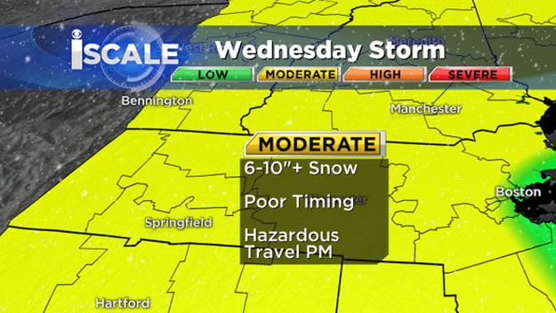
Likely the biggest story with this event is the poor timing.
Check: Traffic Updates
There will almost certainly be delays piling up by Wednesday afternoon and evening.
Check: Amtrak Updates
During the daylight hours, as the rain changes to snow, it will initially have a hard time sticking to the roads.
Check: Logan Airport Updates
Three days of very mild weather ahead of the storm has heated the surface to a good degree. The best snow accumulation this time of year almost always happens at night and I suspect this storm will be no different.
So, the first several hours of snowfall may be lost just due to melting upon contact.
I would expect the most significant accumulation to happen between 4 p.m. and 10 p.m. when snowfall rates of 1-to-2 inches per hour will occur in spots.
After 10 p.m., the precipitation will gradually diminish from west to east and it will be long gone by Thanksgiving morning.
The sun will be peeking out by the time the high school football games begin, albeit over a very snowy landscape for most cities and towns.
HOW MUCH SNOW?
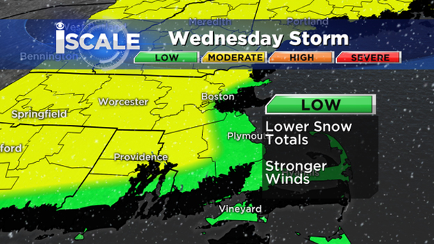
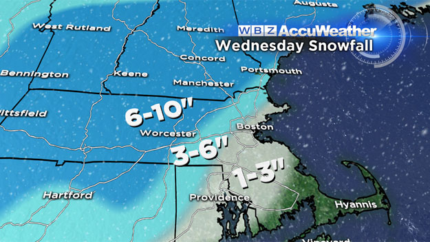
Cape Cod and the Islands: None
Immediate coastline from Cape Ann to Logan Airport to the South Shore: 1-to-3 inches
Just inland from the coast (a few miles), including western portions of Boston and the immediate suburbs out to Route 128, also all of inland southeastern Massachusetts: 3-to-6 inches
Beyond 128, including the 495 belt from Franklin to Marlboro to Lawrence and Haverhill and all points west and north: 6-to-10 inches
Higher Amounts:
There is potential for as much as a foot in isolated locations. The most likely spots for a "jackpot" would be the Worcester Hills AND anywhere in MetroWest where significant banding sets up (a tough call).
This happens quite frequently with storms like this, where a heavy band with higher snowfall rates will form and sit over a given area for several hours, upping totals in a given region.
WIND AND COASTAL ISSUES
The strongest winds will occur where the least amount of snow is forecast, along the immediate South Shore and over Cape Cod and the Islands.
North-Northeast winds will gust 25-to-50 mph in this region with the potential of reaching 60 mph Wednesday night.
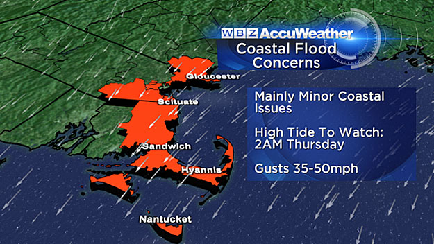
Elsewhere, winds will be a bit gusty but not likely damaging.
With most of the leaves already off the trees, there is a low risk of power outages and tree damage.
The coastal flood risk is low with this storm.
The one high tide to watch will occur around 2 a.m. Thursday, but given that tides are not too high astronomically I wouldn't expect anything more than some pockets of minor flooding.
Follow Terry on Twitter @TerryWBZ
MORE LOCAL NEWS FROM CBS BOSTON


