Dreaming of a White...Thanksgiving?
BOSTON (CBS) - It's not a holiday in New England unless the weather is somehow conspiring to muck it up, and that's where we stand with Thanksgiving around the corner.
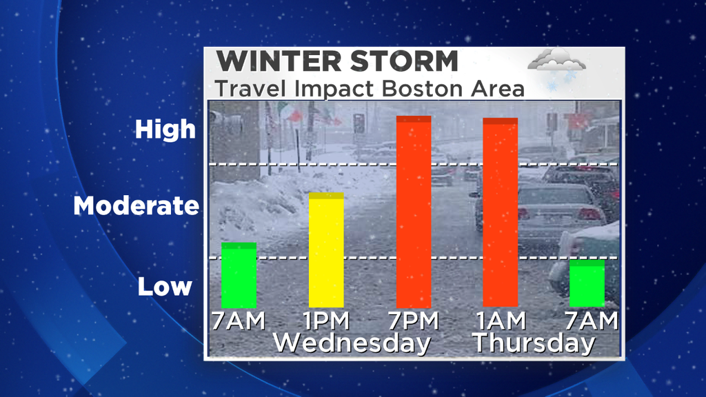
While not a blockbuster storm, this one is sure to add a little extra stress to holiday travel plans. Standing a couple days out, there are still quite a few question marks although the overall picture has come into better focus. As always, the forecast is subject to change so stay updated through your preferred source of weather information (even if that's someone else!) leading up to Wednesday. Rain or snow, it's going to be sloppy out there both on the roads and in the air.
The Full Timeline - Planning Out The Storm
Let's start off with the timing first. If you want to take care of business, stock up on the fixings (beer possibly an important staple with this forecast), or hit the roads - Tuesday is your day. We all know there's going to be plenty of traffic out there - it's always busy the Tuesday before Thanksgiving. But so far as the weather goes it's a great choice. Another mild day is expected with temps in the mid 50s to lower 60s and a gusty breeze. It'll stay dry all day, so nothing to worry about there. By all means if you need to hit the road or shop this will be a good time to do it.
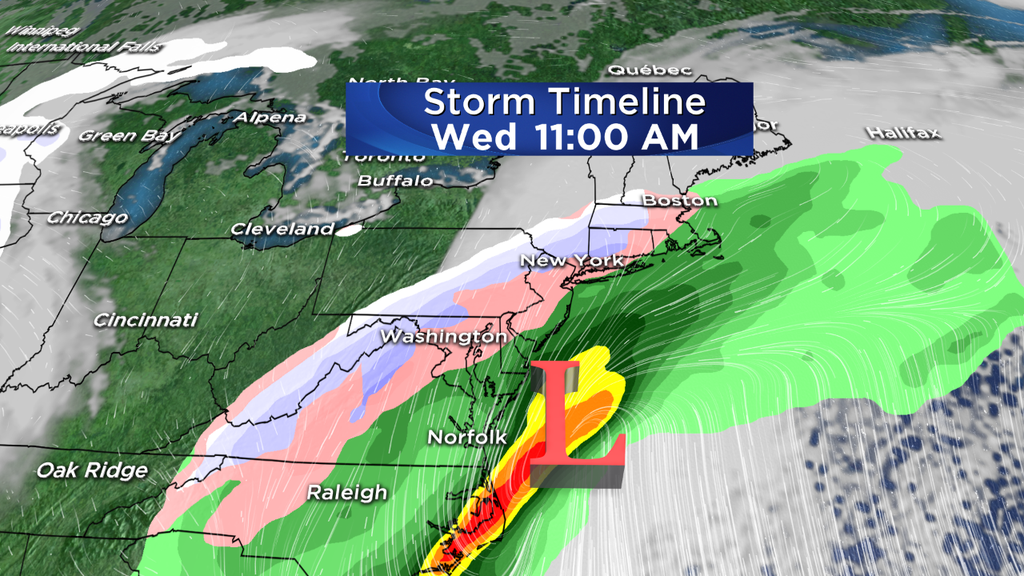
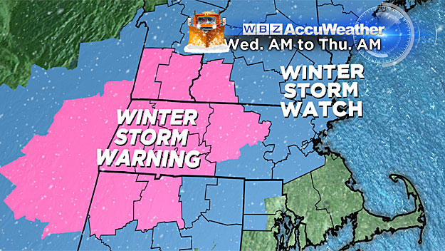
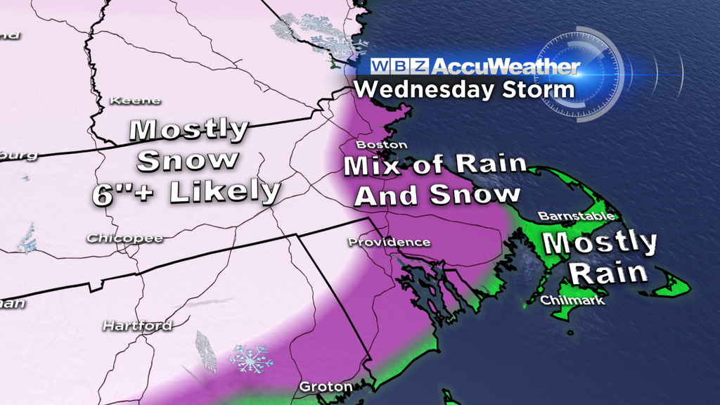
The storm itself will be forming along the southeast Atlantic coast late Tuesday, and we'll start to see the impacts around here Wednesday morning. It looks like a rain/snow mix will move in between 5 and 9am from south to north. The air in place before the storm won't be terribly dry, so evaporation shouldn't be much of a player in this forecast. Some of the interior locations and higher elevations may start out and stay snow the whole time, but many will begin the morning with raindrops. That being said, traveling should be O.K. early in the day.
As we head toward midday and the early afternoon, the changeover will be taking place from rain to snow. This is because the falling rain cools air down to the 'wet bulb' temperature, with the whole column above us coming closer to/below freezing. Higher elevations go to all snow first, then the snow line will expand toward Metro West and the Blackstone Valley.
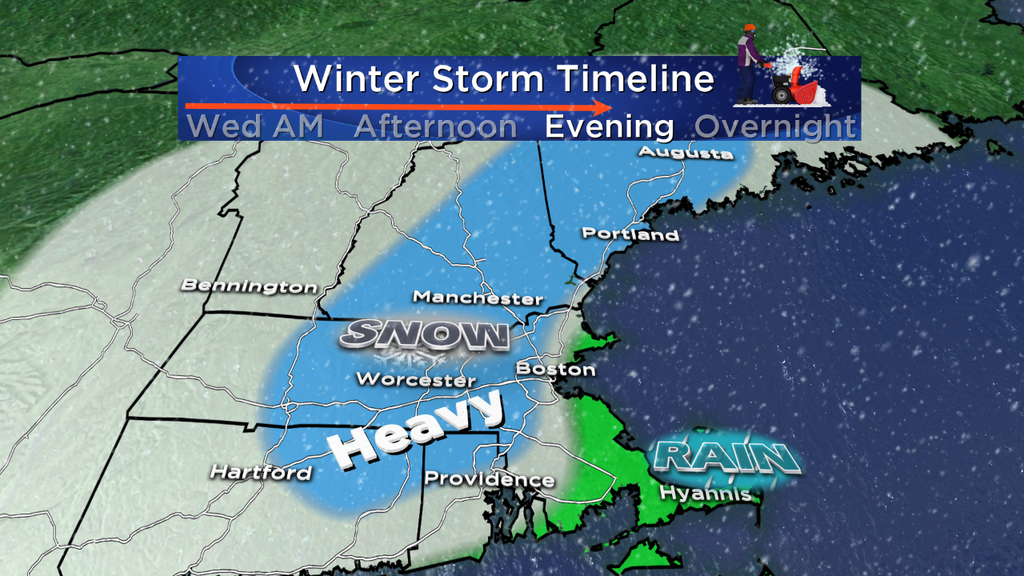
The real focus of heavier snow and nasty travel will be during the afternoon and evening. This is when snowfall rates come up, and of course the sun will go down shortly after 4pm. With cooler temps and higher snow rates, this is when snow should really start doing a better job of sticking. Banding is also likely going to be something we'll monitor for this storm. There's a pretty good chance that a coastal front will set up somewhere near 128/95. East of that front, milder air coming off the ocean will keep the coastline rain/very wet snow for a big portion of the storm. West of it, winds will be more north-northeasterly and will keep colder air in place. Right along and to the west of it, I'd expect the potential for some of the larger snow totals outside of the higher elevations. So between 495 and 128 may be a good 'bulls-eye' for snow totals when all is said and done.
The storm is very progressive because there's no 'blocking' in place to slow it down. That means it'll be scooting on out of here during the overnight and will be long gone by Thanksgiving morning. Travel should be fine on Thanksgiving, although we're in for a chilly Turkey Day with highs in the 30s (lower 40s Cape/Islands). Bundle up for those football games!
Snow Totals - What's Expected In Your Town?
Snow totals are the trickiest forecast we deal with as Meteorologists. Why you ask? There are an incredible amount of factors to figure out in order to come down to the final answer. We're looking at thermal profiles (how temperatures change from the surface to thousands of feet up in the air), storm tracks, factoring in how much will melt when it hits the ground, how the sun angle will impact accumulation, how much mixing may take place, what the ratios will be (how much liquid equivalent converts to snow), etc. It really can be a fools errand sometimes. But hopefully we're on the right track with a plowable snow event for many.
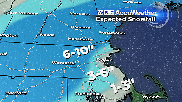
The best shot of significant accumulation of 4-8" is across Worcester County, southern NH, and into the Metro West region. Higher amounts near 10" are possible for the highest elevations and where the banding we talked about earlier takes place. Totals will likely drop off pretty quickly for western New England, and again for southeastern New England where more mixing/rain will factor in. For most, this will be a pretty wet snowfall that will be sticky and clinging to trees.
In the annually cruel twist of having your biggest city in the toughest area to forecast snow, Boston will be tricky. Right now I'm thinking 2-3" downtown. The fly in the ointment would be a track slightly farther east, which could drag the snow line farther east along with it (and the higher totals). As always, check in with the forecast on Tuesday to make sure things haven't shifted. It's weather - always fluid!
For far southeastern Mass., the rain may end as some wet snow toward the tail end of the event. This likely won't accumulate much as it'll be wet and will have been raining all day, but don't be shocked if you see some snowflakes Wednesday night. 1-2" of rain may fall on the Cape/Islands with this one.
What Type Of Storm Is This?
We're dealing with a bit of an interesting animal with this storm. It's not a powerhouse cyclone undergoing rapid intensification (bombogenesis - everyone's favorite winter weather word!). It should end up modestly deep and honestly those are the most difficult to forecast. The big ones do their thing, the little ones theirs. But the in-betweeners can be a real pain.
The reason for this is that dynamically it's not a really impressive setup. The jet is whipping by overhead at 200 knots, but it's not perfectly aligned for rapid intensification. The trough that's digging in is a little flatter than most. The vorticity-maximum swinging in isn't compact and negatively tilted. This setup is more of a wave of low pressure forming along a front, throwing moist air over the top of cold air. Winds may gust 40-50mph at the coast, which isn't anything terribly unusual for us. It's moving fast enough so that coastal flooding should be minor. And really it wouldn't produce much snow if it didn't have origins toward the Gulf of Mexico and southern jet stream. Pretty intriguing.
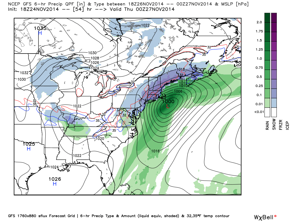
18z GFS forecast from Monday. Note the central pressure - around 1000mb. Not exactly impressive. It may dip into the 990s but even still this isn't as impressive from a wind generation/intensity perspective as a couple of the recent nor'easters. Source: Weatherbell
My snow totals are a little higher than many because of this storm's 'modesty'. It's bringing enough moisture to the table, but shouldn't be strong enough to really throw a ton of warm air in off the ocean with a coastal front farther to the west. So long as the track does what we think it will (head very close to the benchmark, 40N/70W) there should be enough cold air to produce a period of solid snow. I've liked the GFS look for this storm for the past several days, and the ECMWF has moved in that direction on Monday. The NAM is likely still a little too far east, and the RPM may be drunk (as usual).
Should I Trust Model Snow Accumulation Numbers?
NO. DON'T DO IT. Honestly it can be a decent tool, and I'm sure you've seen them posted all over the place. Some news outlets actually show them on air. But frankly, they're not a good way to figure out snow totals. They're too rigid (use a 10:1 ratio), they sometimes include precipitation that falls as sleet/freezing rain as snow, they count everything that falls under a certain temp as snow, etc. Plus, they change every 6 hours! When these are shared/shown with often completely different numbers 4 times a day, it's really useless and confusing to the average weather consumer. It's a shame that these have become so viral in recent years when they're really just guidance. They are NOT a forecast. Be very wary when looking at these. If anything, you may want to look at 'snow depth' as a better means to an end. That at least factors in some melting, compacting, etc.
Who Else Is Dealing With This?
Most of the focus for Wednesday travel headaches will be in theI-95 corridor between southern Maine and North Carolina. In particular, I'd expect the D.C.-Philly-New York-Boston corridor to be very sloppy. Just a few people live in those cities and points between, so I'm sure the roads are going to be pretty jammed up. All of those cities are dealing with the same rain/snow line issues as we are. The higher snow totals are likely west of I-95, but all those airport hubs will be impacted due to rain/snow and volume. If you're heading out or expecting someone to come in from another location, expect there to be some delays and cancellations.

What Comes After The Storm?
Pretty quiet stuff. Thanksgiving is chilly and dry with highs mainly in the 30s, and where there's fresh snow we may see some 10s Thursday night for lows. Friday is another very cold day with highs in the 30s and a gusty breeze - possibly a few flurries mixed in. The weekend also looks very quiet with more 30s/40s on Saturday and possibly a run at 50 on Sunday. So whatever snow can fall will stick around for a while! Might be some fun Thanksgiving skiing from Nashoba and Wachusett up into southern VT/NH and Maine. Too bad we had this mild spell Monday/Tuesday to mess with the great man-made snow that had been in place.
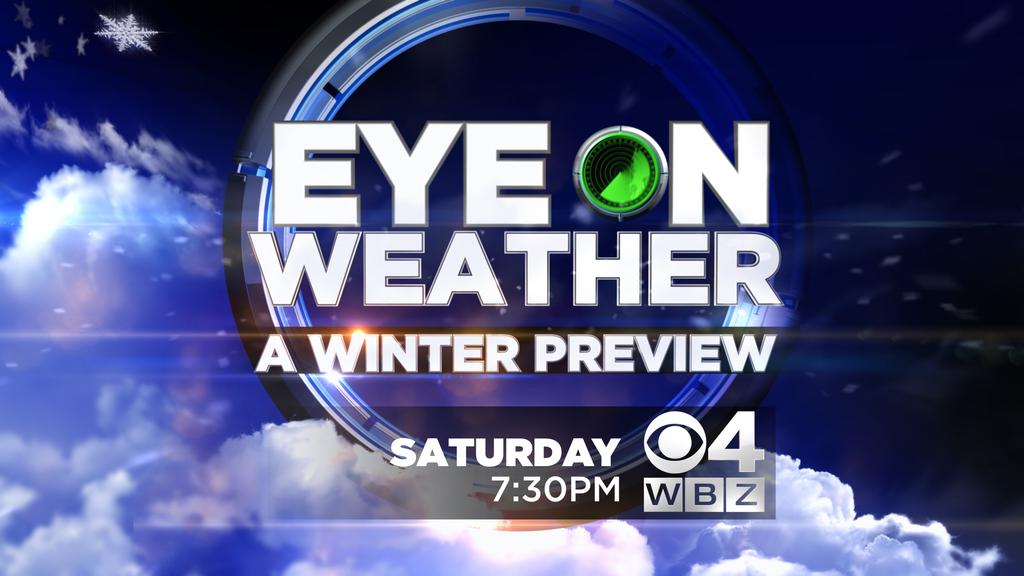
Might also be a fun time to mention that our WBZ Winter Weather Outlook airs this Saturday night at 730pm! Barry, Danielle, and myself have taken a look at the seasonal indicators and come up with a forecast for Dec-Feb. Also some fun stories mixed in and some of the storms you voted most memorable in southern New England history. Hope you can join us, and if not, set the DVR.