'Juiced Up' Storm Could Bring Rain, Snow On Year's Busiest Travel Day
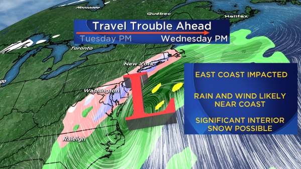
BOSTON (CBS) – Confidence is growing that a significant coastal storm is going to ride up the east coast on the busiest travel day of the year, likely causing major travel disruption.
Download: CBS Boston Weather App
Up until now, the models have been having a tough time resolving this one and with good reason. The primary piece of atmospheric energy has been over the Pacific Ocean, hundreds of miles south of Alaska. Obviously this is not an area where a lot of weather observations and sampling is being done, so the data has been somewhat sparse.
Check: Interactive Radar | Weather Blog | Current Conditions | Share Photos
This should change in the next 24 hours or so with the energy coming ashore in British Columbia and the Pacific Northwest. By Monday night I would expect a lot more confidence within the forecast community.
First, while there still are several "scenarios" with this storm, I think we can just about rule out a complete miss out to sea. Sadly, this crowd-pleasing option is becoming less and less likely.
Odds favor a hit, a significant coastal storm for the entire eastern seaboard.
TIMING OF THE STORM
This storm will be coming out of the Gulf of Mexico, so New England will be the final stop in the east coast tour.
The storm will arrive in Washington, D.C., around 7 a.m. Wednesday, Philadelphia around 9 a.m., New York City around 11 a.m. and early afternoon in Boston.
The peak hours in Southern New England appear to be centered around Wednesday night and very early Thursday morning, something like 7 p.m.-2 a.m.
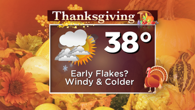
By sunrise on Thanksgiving I would expect the precipitation to either be over or winding down.
RAIN OR SNOW?
It's still too early to call a rain-snow line location.
Given the setup, time of year, ocean temperatures and other variables, the most likely solution in my mind would be for mainly rain at the coast and heavy snow inland.
Again, this needs to be worked out in the next 24-to-48 hours but the farther west you go (west of Interstate 495, into central Massachusetts for example), the better chance this will be snow instead of rain.
This system will be "juiced up."
There will be lots of moisture to work with and likely some banding on the northwest side of the center of the storm, which could be right over parts of our area. Where it is all rain there may be 1-to-2 inches, but where it is all snow, there is potential for a foot or more.
WIND WILL BE A FACTOR
As you might expect, winds will also be an issue. There will be strong northeast winds at the coast (a nor'easter) and somewhat lighter and more northerly winds farther inland.
By Thursday morning the winds will shift to the northwest and stay gusty. I am not anticipating a major coastal flooding threat for a few reasons.
First, tides are not that high, astronomically speaking. In addition, this is a quick moving storm, affecting just one high tide cycle and not leaving enough time for seas to build significantly.
High tide of greatest concern would be around 2 a.m. on Thursday.
There is still plenty of work to do on this storm, but it's safe to say this one will be in the headlines all week.
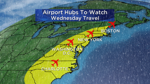
If you are one of the millions set to travel in New England and along the east coast on Wednesday, I would urge you stay tuned to updated forecasts and perhaps start to consider leaving a day earlier or later if possible.
Follow Terry on Twitter @TerryWBZ
MORE LOCAL NEWS FROM CBS BOSTON