Abandoned Vessel Off Boston Sparks Social Media Intrigue
BOSTON (CBS) -- Mariners Lenny Guadino and Dom Tosto have moored their boats at the Orient Heights Yacht Club in East Boston for four decades. So they know they know the waters around Logan Airport.
Perhaps that's why they were a bit puzzled today as they peered through their binoculars at a spot in some grassy, mud flats – a few hundred yards from ongoing runway construction.
"It's not a mystery I don't think," Guadino said.
But social media ran amuck over the weekend when Reddit users got a hold of a Google Earth photo, which shows something curious in the waters just north of Logan.
It's rectangular and white, maybe 100 feet long and 30 feet wide, and appears to be surrounded by large timbers.
Reddit readers suggested it was everything from an 1880s shipwreck to an old pier.
"God knows how old it is or how long it's been there," Tosto said.
The satellite photo makes it look like the object is in an open channel. But it's actually in some grassy, mud flats – plainly visible at low tide – but underwater when the tide's high.
Closer inspection isn't really possible because the object that has now melted into the mud is inside the white, Homeland Security buoys – where intruders typically draw speedy, armed attention.
"I don't think any ship would be able to get up in there," Tosto said.
Back in the days before the airport, though, it could've been the final resting spot for an old barge or schooner – now swallowed up by sea grass near what used to be Wood Island Park before Massport claimed the property.
"I don't know," Guadino said. "It's hard to tell."
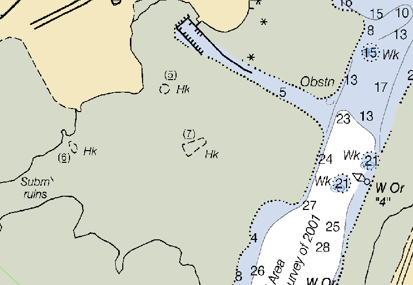
But the head scratching came to an end this afternoon when scientists at the National Oceanic and Atmospheric Administration (NOAA) discovered the object already listed on their nautical charts.
They list it as a "hulk" – an abandoned vessel without even a noteworthy name – sitting 7 feet off the seabed.
That piece of history failed to tickle the fascination of our mariners.
"No, absolutely not," says Tosto.
But for those who might be curious, you can check with NOAA's Office of Coast Survey -- it's right there on Boston Harbor chart 13272 – labeled (7)Hk.
MORE LOCAL NEWS FROM CBS BOSTON