More Drought Denting As Coastal Low Spins
Find Eric Fisher on Twitter and Facebook
Weather is a constant search for balance, and we're doing a fine job of it so far this October. A few bouts of rain have helped quench the very dry summer/early fall that left parts of the area (especially southern New England) in drought. Some communities have picked up 3"+ this October, and a slow-moving nor'easter will help provide more water for the backyard rain bucket over the next several days.
 Eastern U.S. Water Vapor Loop
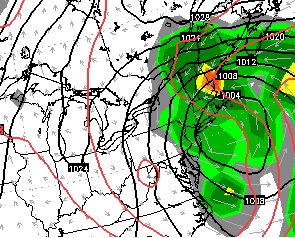
The energy we're watching is diving down out of the Great Lakes - and will become a cut-off low today. A 'cut-off' is basically a mid-level low that gets cut off from the main thrust of the jet stream. The jet stream is the usual mover of storms in the atmosphere, so these can get left behind for a few days until receiving another kick. As this sets up Tuesday, we'll see some showers start to rotate in out of the south. It's definitely not a total washout day, and there will be some 'haves' and 'have nots' so far as raindrops go!
Tuesday:
A few scattered showers for the morning drive, especially eastern MA. We'll see the scattered areas of rain become a little more numerous as the day wears on, and in particular from the Seacoast of New Hampshire down the coastline to the Cape and Islands. This is where there may be enough instability to produce some downpours with embedded thunder. Farther to the west, any showers and overall rain totals look lower. Just a good day to keep an umbrella handy, plus lots of clouds and highs in the 50s to near 60.
Wednesday and Thursday:
ECMWF forecast MSLP and rain for Wednesday evening. Note the heavier bands of rain/wind to the north into Maine and central/northern New Hampshire. Source: WSI Energycast
We'll watch the low strengthen and start to drift northward, eventually centering itself nearly on top of us. While it won't be raining all the time, rounds of showers and locally heavy rain will rotate around the low and into the area. You can generally count on lots of clouds, wet conditions, a gusty NE breeze, and cool temps (50s). As it stands now, the best shot of steady rain looks to be during a period from late Wednesday into early Thursday. And while we get decent rain out of this, the heaviest should be directed to the north side of the low - New Hampshire and Maine. This is where a real soaking could be in order and perhaps even some minor flooding issues.
Total Rainfall:
It's really all good news when it comes to rain from this system. Although it looks fairly potent, the 1-3" of rain that looks likely here locally will be spread out over about 72 hours. That will easily be soaked up by the ground, and shouldn't lead to any significant flooding concerns. So we get all benefit, no risk! So far as the viewing area goes, the highest totals will likely end up being in southern New Hampshire. I wouldn't rule out a few totals 3"+.
To the north across central New Hampshire and into Maine there may be some totals reaching or even topping 5"! That's also spread out over quite a bit of time (two days). Rivers will run high and there could be *some* flooding concerns...but it doesn't look like a major event in the making. Something we'll continue to monitor. It has been pretty dry to the north as well over the past couple of months - and for most locations it'll be welcome rain.
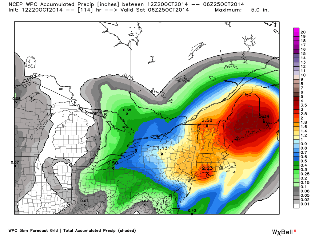
Forecast rainfall this week from the WPC...solid totals for all but a big time soaking for Maine and parts of New Hampshire. Source: Weatherbell
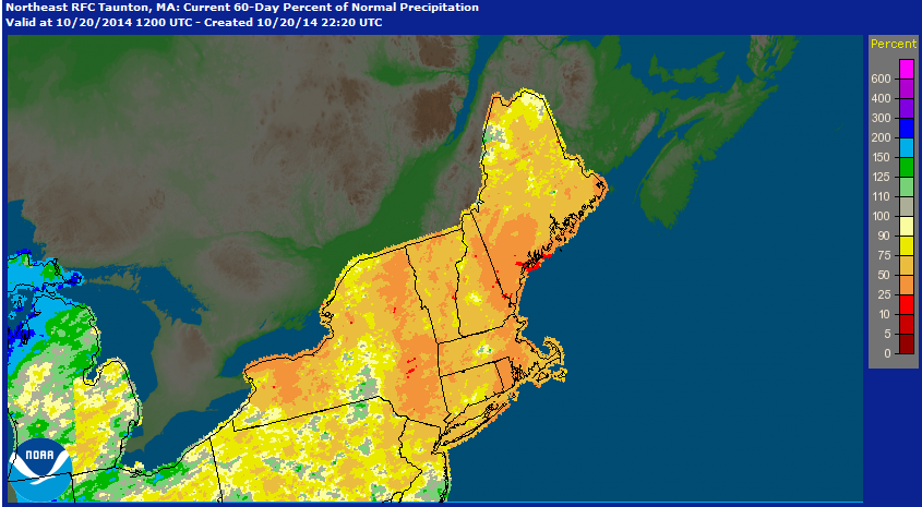
NOAA's AHPS precipitation analysis over the Northeast. This shows the 'percent of normal' rainfall we've seen...and as you can see nearly all of the Northeast is in the hole over the past 60 days! We've started to make up ground in October, and this week will certainly help.
Wind Concerns:
With the low setting up shop nearly on top of us, the main threat of strong winds will likely stay just to our north, but not by much. Couldn't rule out some gusts to 50mph for coastal Maine, and gusty winds will blow across much of northern New England, New York State, and down into the Mid-Atlantic around the low. What do we get? Well...I think it's a situation we need to keep tabs on as it may change over the next 24 hours. Right now, it looks like the strongest winds would stay across Maine and perhaps nudging down into the New Hampshire coast. But I wouldn't rule out some strong (40mph+) winds getting all the way down to Cape Ann late Wednesday into Thursday. While making it feel ugly in general, this may also push a lot of water into the north side of Cape Ann. Stay tuned for any updates on this in case the core of strongest winds shifts southward.
Plus, with so much wind up out over the open ocean, the surf will get whipped up over the course of this week. Some of that rough surf over multiple days may lead to some beach erosion here at home...especially the North Shore up into the Seacoast.
When Does It End?
At the moment I'm not expecting much rainfall on Friday outside of some scattered showers, especially in the morning. But a lot of low-level moisture leftover from our gloomy stretch, combined with a chilly northerly flow, should help keep the clouds around. Expecting it to be a mainly gray day with maybe some late-day sun and chilly with highs in the 50s.
This weekend looks more promising, although no slam-dunk. Models are *not* in great agreement on how Saturday and Sunday will pan out just yet. It looks like some fast-moving Pacific energy will race across the country and help drag a cold front through either on Saturday or Saturday night. Before that happens we should at least get some sunshine and milder temps in the 60s. But behind it the wind will pick up and Sunday looks pretty gusty. If you trust the ECMWF (and I do) Sunday looks chillier in the 50s with a chance for some spotty showers. For the higher terrain of New England, that could again be a round of snow showers for the higher elevations! But it's only Tuesday so expect some of these details to change a bit before hit the last full weekend of October.


