Wild U.S. Weather Ahead?
Find Eric Fisher on Twitter and Facebook
Let's start with some good news on the blog - rain! Yesterday we managed to squeeze out enough to bring Boston to a tie for its 10th driest September ever recorded. Of course Boston is just one point, and the standings vary considerably from location to location. Blue Hills Observatory in Milton saw its driest September ever recorded (previous record had been set exactly 100 years ago; 0.45" in 1914). We're awaiting the final word from them on their official total for September, but are assured it's below that! They were at 0.33" through 1pm Tuesday.
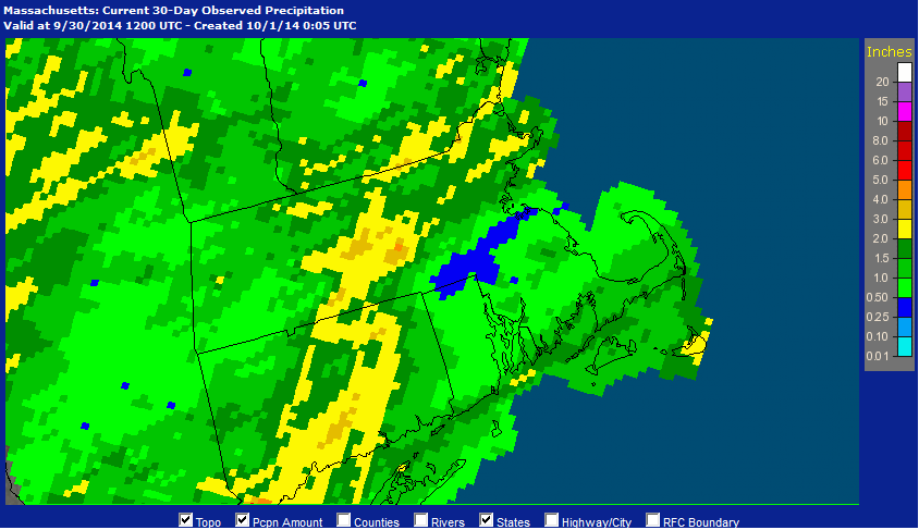
Observed rainfall over the past 30 days. A big hole of 'have nots' along a corridor from approximately Douglad and Uxbridge eastward through Walpole and Canton to the South Shore near Hingham. Source: NOAA
Then you look across the Cape and Islands, or across Worcester County, and some spots have seen over 2" of rain! Most of that across the SE zones came last week with a system that just barely grazed southern New England. When you take a peek at Doppler estimated rainfall over the past 30 days (doesn't include most of Tuesday's rain - which ranged from nothing to about 0.2") you can see a clear hole. The Blackstone Valley, reaching over toward the Mansfield area and over to the South Shore, has been the most parched of all.
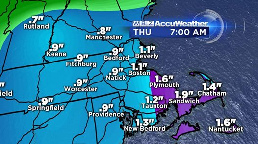
This is just ONE model's output for rainfall through Thursday morning. Some of these numbers may be a bit high, and the placement could shift a little farther west. But in genera, I'm thinking that many towns will end up with amounts between 0.5" and 1.5" for this time frame. We'll take it!
Today's rain is looking a lot more promising than it was at the start of the week, which is a good thing! The clouds are still here, the cool temps (50s to low 60s) are still here, and we're introducing a new upper-level low to today's setup. This was across the eastern Great Lakes yesterday, and will help add some lift in tandem with a surface low well off our coast to the southeast. The overall result - our best shot for a region-wide rainfall in months! A nice moist inflow will come in off the Atlantic. Although it's tough to say exactly who will end up with the biggest totals, many should be seeing beneficial rainfall today. Very much needed, and yesterday's damp weather should have helped to moisten up the soil and get it ready to accept this gift!
 Water Vapor Loop
Today's disturbance is the little swirl you see tracking over the NYC area/southern New England
Things calm down a bit for Thursday and Friday, but the really interesting stuff will be getting underway to our west. A potent storm system will wrap up across the Plains starting on Thursday, then race up toward the Great Lakes. Behind this system will be cold, wind, and maybe even some snow showers for the Upper Midwest. To the north, it gets even more (not) fun. A significant snowstorm is looking likely for parts of Ontario and Manitoba this weekend. They get into the winter action a little earlier than us here in the Lower 48!
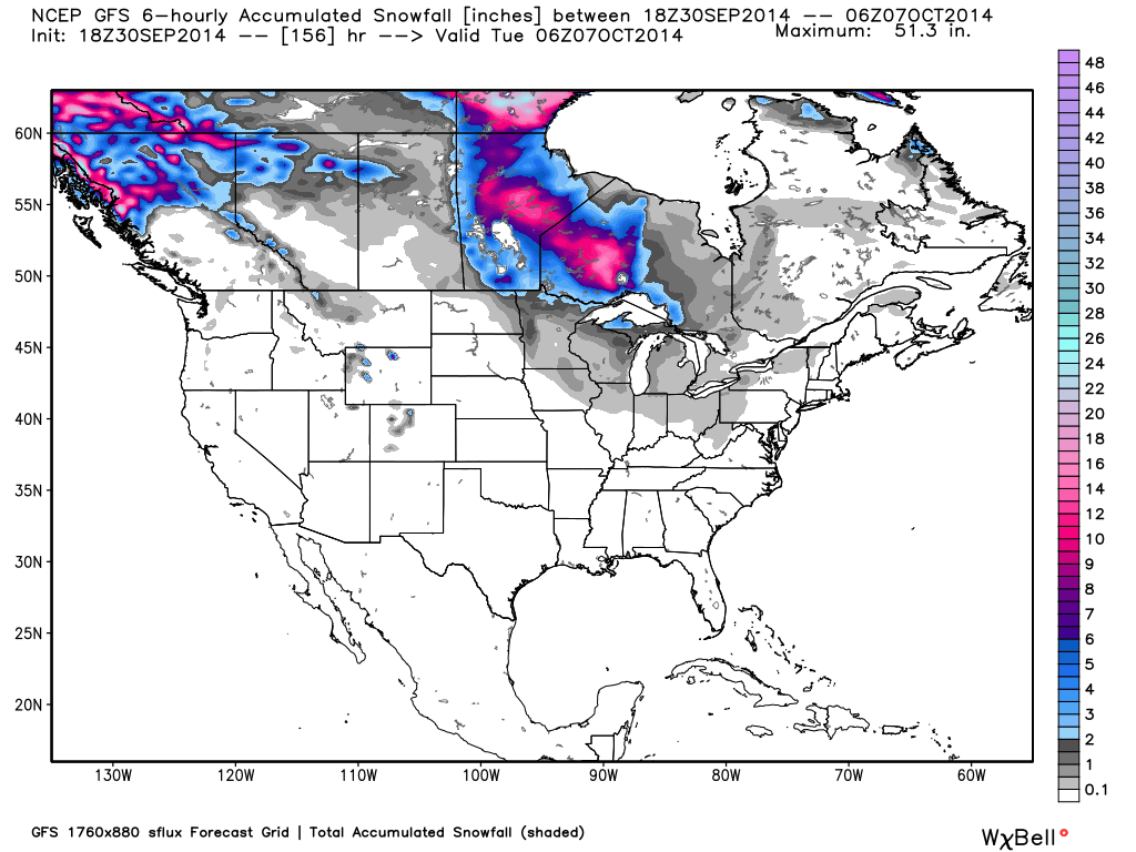
GFS snowfall for the weekend - yikes! Check out that bulls-eye across central Canada. While each model varies on exact placement/amounts - all have a significant snowstorm in this general area over the weekend. Source: Weatherbell
The plunge of cold air behind this system will get all the way down into the deep south - with lows in the 40s for many of the Gulf Coast states by this weekend. We won't get the brunt of the cold air, but we WILL get a batch of gusty showers/rain on Saturday as it drags a cold front across. The actual rain totals are still in question for Saturday - but the timing is looking like it'll take place during the 2nd half of the day. Typically storms like this generate a fairly thin line of showers/few downpours. More details on that as we get closer, but I wouldn't expect all-day rain at this point.
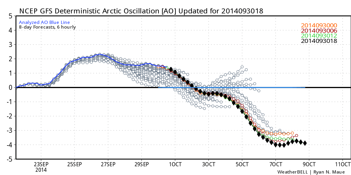
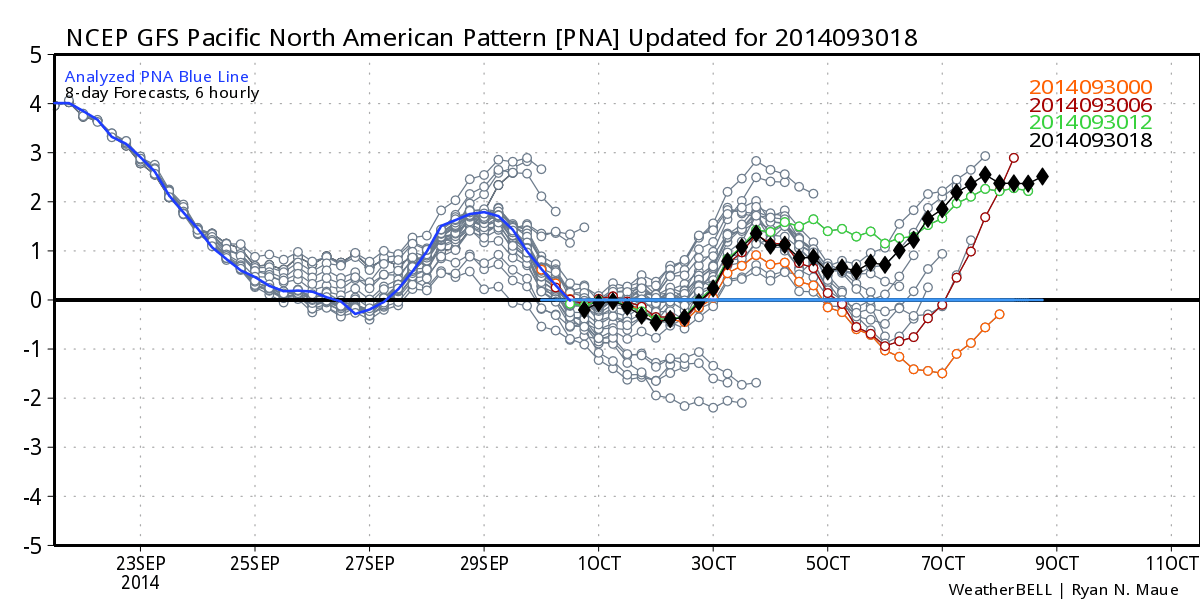
What's truly interesting is how the teleconnections are shaping up for this weekend and beyond. Nearly all the models are in good agreement of an Arctic Oscillation (AO) absolutely tanking and the Pacific North American Pattern (PNA) going strongly positive. This is a fantastic setup for a very high-amplitude pattern, similar to what we saw last winter. It should help generate a strong ridge over the west with hot temperatures returning, and a deep, potent trough in the eastern U.S. (sound familiar?). Overall it looks like below average temperatures are going to set up shop in the east and stay there for quite some time, and hot/dry weather will once again take control of the west.