Fall Into Summer? Late Heat & Other Musings
Find Eric Fisher on Twitter and Facebook
So typical of our weather. Wait all summer for the big heat, then get it when everyone goes back to work and school. When the fall decorations are out, apple orchards are ready for the picking, and pumpkin spice fiends flood the cafes like zombies. It's the pumpkin patch walking dead out there, and it's around 90 degrees. Just what you'd expect!
We've got a few more days of summer warmth to go before things start to trend back toward 'normal' (whatever that is). Today high pressure is on control - providing plenty of sunshine and some local sea breezes forming for the afternoon. Most towns will spike well into the 80s, but humidity will stay in check for one more day. Return flow takes over on Friday (southwest wind), and that's going to kick it up a notch to end the week. Here we have another shot at 90º as we add to the tally late in the game. Dew points will climb through the 60s, perhaps to 70º by the end of the day. That means a sweltering afternoon for after school sports, so make sure the kids are staying hydrated! Heat indices will likely top in the low to mid 90s during the afternoon.
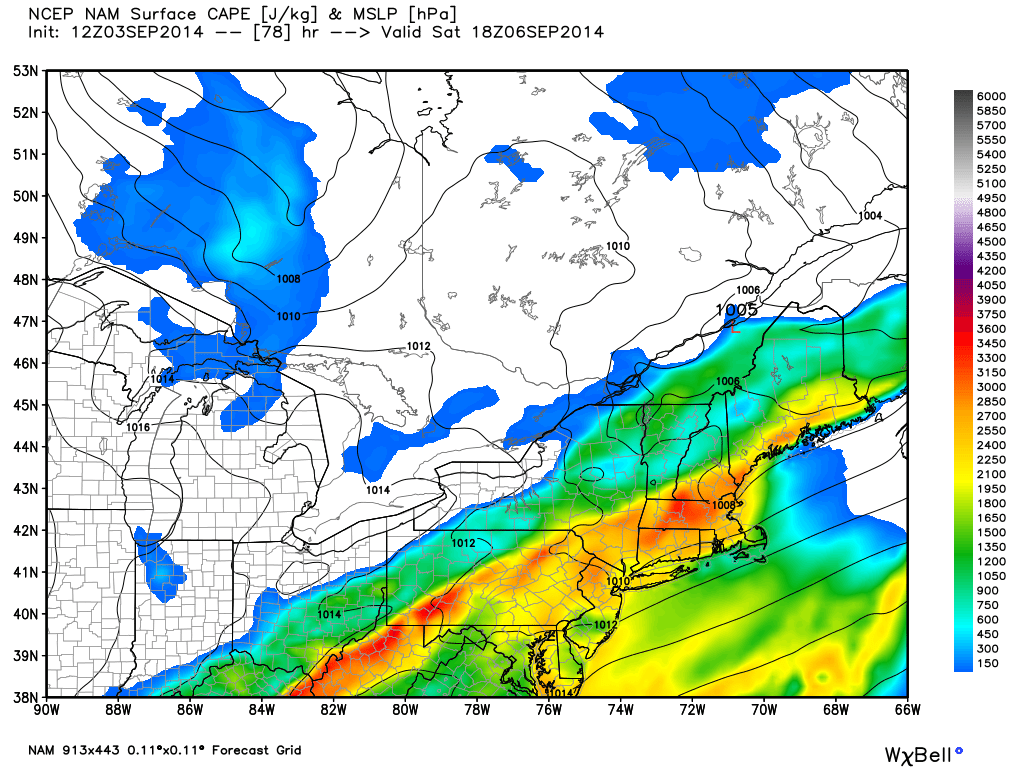
NAM forecast for CAPE on Saturday. If this pans out (combo of high heat & humidity) we should see some strong thunderstorms. Source: WeatherBell
Steamy weather is expected into Saturday, with very high humidity and more warm temps. We'll be eying a cold front, but the timing is still a little uncertain. If it holds off until late in the day, we could hit 90º again in parts of the area before the storms roll in. A little faster and clouds will stop that from happening. Either way, it'll feel tropical out. Wind shear doesn't look too impressive on Saturday, but if we get plenty of warming then CAPE values will be high and these storms will be able to feast on some unstable air. I'd be surprised if we didn't get strong to severe thunderstorms to pop during the afternoon, starting first in western New England and then heading SE. Any storms will also feature torrential downpours and the threat of flash flooding, since the atmosphere will be primed with moisture. If you have any outdoor plans, keep a close watch on the forecast.
Once we get clear of that front, some of that 'normal' fall air is going to move in. I always put 'normal' in quotes and banish it from our graphics here at WBZ, because really there is no normal. Just averages, which usually aren't what you get anyway! Just a measure in the middle of all the mood swings nature throws at us. In any case, fans of cooler weather will be happy with the Sunday through Wednesday stretch. The front will slowly edge out of the area on Sunday, bringing drier air in from west to east as the day wears on. Showers may linger for a while in the morning, especially across the Cape & Islands. Highs will top out in the low/mid 70s.
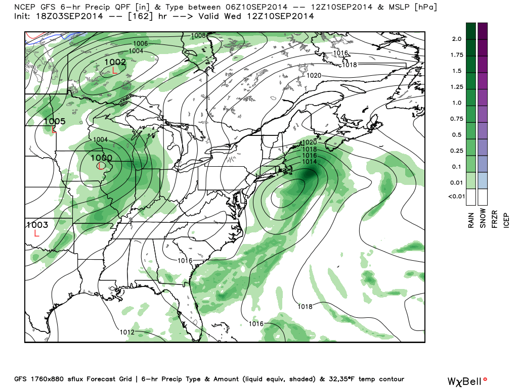
GFS forecast for MSLP and precip on Tuesday night of next week. A coastal scenario we'll be keeping tabs on. Source: WeatherBell
While Monday looks great, there's some interesting model fodder going for Tuesday/Wednesday. The GFS keeps trying to form an interesting tropical or sub-tropical low just off to our south. The ECMWF is less bullish on this, but it bears watching. If a low can organize close enough to us and float northward, then we could be in for a soaking and a cool onshore flow. If it slides out south, then we just have a couple of seasonable days. Something to put on your 'keep an eye on it' radar.
Another notable is the cold shot that's been signaled in the models for the middle of next week. The first real blast of chilly Canadian air this fall is poised to hit the Upper Midwest. There may even be a few flakes to go along with it! In fact, there will be a LOT of snow falling across Canada over the course of the next 6 days with this unseasonably cold air mass lurking. It looks like the Midwest will take the brunt of this one, and we won't be looking at any unusual cold blasts around here. In fact, that same trough may help building some ridging over us in the jet stream, allowing for some warmer air to try to sneak back in late next week.
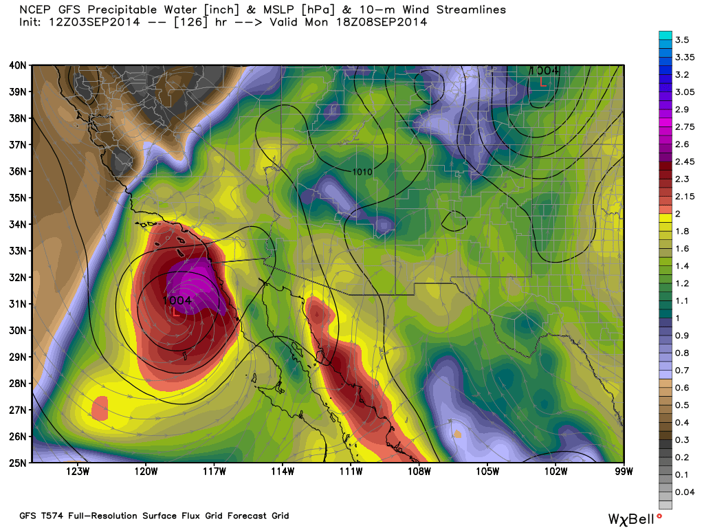
And finally, there's a storm in the tropics that's of interest. While the open Atlantic is expected to be dead as a doornail for a significant stretch of time (MJO - Madden Julian Oscillation, not in favor of action), Norbert is making noise in the eastern Pacific. This may become a powerful hurricane, and it's going to track very close to the Baja Peninsula. So close in fact that it should spread quite a bit of tropical moisture into southern California and the desert southwest by late in the weekend. This should promote widespread thunderstorms and downpours, and likely quite a bit of flash flooding as we head into next week.
 Norbert satellite loop