Weekend Rain Dodging
Find Eric Fisher on Twitter and Facebook
Oh the angst and pressure of a weekend forecast in summer. I know most of you probably won't believe it, but we sit here and agonize with stomachs full of indigestion when a potentially stormy weekend forecast is in the works. The parades, the parties, the weddings, the brides with pitchforks, the beach trips...it's not a fun gig. And while we've had a great run of weekends all summer long, just one bad one will leave a sour taste in many a mouth. Without further ado, here are the thoughts on how this one will play out.
The main troublemaker for this weekend is the same front that helped produce the Revere tornado earlier in the week. One that system cleared out, it has proceeded to sit out over the Atlantic and has barely moved all week. But now, in response to the big Midwest jet stream trough retrograding (moving west), that front will buckle and move back toward our shore. At the same time, a mid-level disturbance will ride up the East Coast adding a little fuel to the fire, and high PWAT (moisture) air will swing back overhead. In particular, the real juicy air will come up over Cape Cod and the Islands.
 IR satellite image with stormy weather along the East Coast
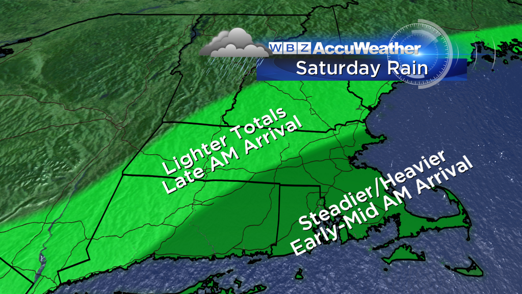
Timing...
It looks like the first round of steady rain should approach the South Coast shortly before dawn on Saturday morning. This will gradually head up to the north and overspread just about all of eastern Massachusetts/southern NH during the mid/late morning hours.
Now there's one model that's more bullish on rain than all the others, and that's the ECMWF. It's been the steadiest all week, but it juiced up its projected rainfall on Friday's 12z run. While something that wet may not pan out, I do believe that a pretty steady rain can be expected from a line Boston-Worcester southeast (1-2" possible). The timing of this should be centered around the morning through mid-afternoon before this initial wave rolls out to the northeast. If you live northwest of that line, I'm expecting rain totals to taper off sharply. Northern Worcester/Middlesex and Essex Counties, as well as much of southern NH, may not see very big rainfall totals. Instead you'll see some lighter rain (0.15-0.50"), a few downpours, a lot of clouds, and cool temps in the upper 60s/low 70s.
The good thing about this rain is that although it will be wet, it won't feature any severe storms or very strong winds. So if you want to have an event outdoors, a tent will probably do the trick. The heaviest stuff that may make it more difficult to manage would be far southeastern MA where some isolated thunder can't be ruled out. It's also not great news for PMC riders and fans...they'll be riding straight into the heavier stuff as the morning wears on.
By the late afternoon/evening, this main slug of rain should be on its way out. So late day/night plans should be in O.K. shape. Still a lot of clouds, a few lingering showers, but otherwise manageable.
Sunday...
The trickier and more nuanced day of the two. The stationary boundary will still be around, but the forcing isn't as direct. Right now I'm thinking we'll get two distinctly different areas of rain developing. The first area is interior New England, especially SW New Hampshire, WMass, and southern VT. Enough instability should be generated in a moist atmosphere to get sct'd downpours and storms going during the afternoon. These may drift SE into our viewing area later in the day.
Camp #2 is the Cape/Islands. The stationary front will be the primary driver, keeping rounds of showers/thunder and some fog nearby all day. Not the best of forecasts for the PMC, I know. This year will definitely be a journey in strength and determination as most will have to ride through at least *some* heavy rain during their journey. The onshore flow will keep temps quite cool...mainly in the 60s to near 70 on the Cape/Islands all weekend.
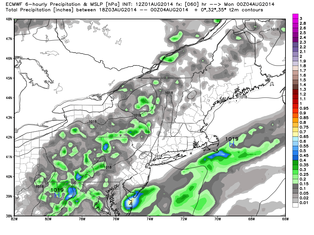
Sunday forecast as interpreted by the ECMWF. I agree with this look...a band of rain likely heading across Cape/Islands, with storms firing across interior sections of the Northeast. We'll have to see how far SE those storms drift into our neck of the woods during the afternoon/evening. Source: WeatherBell
Next Week...
More of the same in the forecast for Monday. Our lawns and gardens will continue to stay green! Scattered downpours and thunderstorms should be generated again in the afternoon, with temperatures making it to a warmer spot than the weekend (low 80s, muggy). We're still in the soup for Tuesday, with some isolated storms coming during the afternoon. And then finally, it looks like the blocking in the atmosphere will break down and we'll get a cold front to swing through on Wednesday. This will bring another risk of storms, but the end of next week is looking fantastic! If all goes well, this will send down a comfortable, warm and dry air mass for the end of the week through next weekend. Possibly making amends for this one?
And if you're wondering...we're also keeping tabs on Tropical Storm Bertha. It's not a very healthy storm with a ragged appearance and a pretty hostile environment of dry air and wind shear to battle through as it tracks through the islands. If it survives, it'll be off the East Coast by the Tue/Wed time frame. It's likely that no matter what state it's in at that point, it'll be guided out to sea by a front heading toward the coast and around a strong sub-tropical ridge in place across the Atlantic.
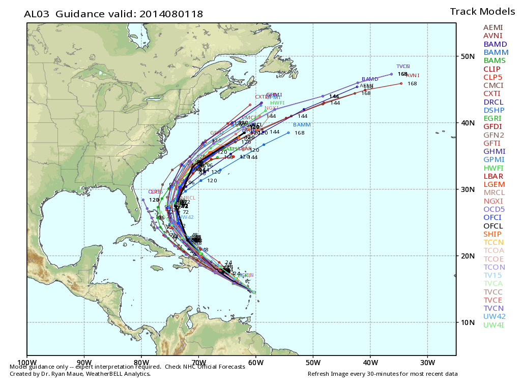
Spaghetti plot of model solutions for Tropical Storm Bertha into next week. Source: WeatherBell


