Revere Tornado - Communication of a Rare Event
Find Eric Fisher on Twitter and Facebook
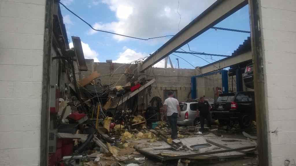
An auto body shop destroyed by the Revere tornado. Courtesy: Eric Fisher
Standing in Revere on Monday evening, it truly boggled my mind that no one was seriously hurt. This was a storm that didn't have a tornado warning on it until after it passed the city, spun up and dissipated within minutes, and during that time blasted the heart of a densely populated area with 120mph winds. Based purely on the amount of debris, it's really remarkable no one took a direct hit. The only killer tornado of this century in Massachusetts continues to be the Springfield tornado of June 2011.
I wanted to touch on a few notable pieces of information as it pertains to this storm, starting first with the timeline of information. While some of you die-hard blog readers are well aware of the process, I can easily see that many people do not know where watches come from, warnings come from, why they're issued, or what they even mean! This continues to be a difficult frontier of weather - trying to communicate to the masses important information - and to have them know exactly what to do when they get it.
Outlooks/Watches - Where do they come from?
Severe weather outlooks are the first part of this chain. These are products issued by the Storm Prediction Center in Norman, Oklahoma days in advance of impending weather. There's a large contingent of severe weather professionals who make up the staff at the SPC, and they often do an absolutely fantastic job. Usually after an outbreak of storms, you can match up the storm reports with their outlooks and the fit neatly inside. I think many in this day and age take for granted how impressive this feat is. HOWEVER - they have all but admitted that they don't have a full grasp of the nuances of New England severe weather. Many of those who work there (and I'm making somewhat of an assumption here) are trained and focused on the outbreaks of the Plains, Midwest, and Southeast. This is where a big chunk of all the U.S.'s severe storms occur, but the factors that drive New England severe weather can be much more complicated. These influences include terrain, the nearby ocean, micro-climates...it's a mess! The good news is that the local National Weather Service office and your trusted on-air Meteorologists DO understand how it all works very well, and were all talking about Monday's severe weather threat days in advance. Everyone should have been aware that Monday would be a very stormy day.
I was disappointed to see that the SPC did not highlight us on Monday in their 'slight risk' area, and they also did not issue a watch on Monday morning. This is the FOURTH time in a row there has not been a watch up while our area has been under tornado and severe weather warnings. I'm hopeful that someone will take a deeper look into this and hopefully a stronger collaboration can develop between SPC and local NWS offices to help make sure advance notice of severe weather is provided.
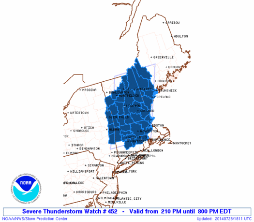
This was the only watch issued by the SPC on Monday for our area. A Severe Thunderstorm Watch, which was issued at 210pm
Warnings - Local NWS takes the reigns
Warnings are issued by local NWS offices. You'd be amazed to hear how many people think we have control over these at local TV stations, or that we issue them to 'manufacture' severe weather events and get ratings. Honestly I cannot possibly fathom the mind that could think that's true...probably the same people who think we never landed on the moon. But I digress. Only the local NWS office can issue warnings - whether they are tornado warnings, severe thunderstorm warnings, flash flood warnings, etc. It's not hype. They're only issued when specific criteria are met, or when a dangerous situation is unfolding. A warning means 'imminent or occurring,' so it is the upgraded version of a watch.
In the case of Revere, it was admittedly close to impossible to have a tornado warning out before the funnel dropped. This was a tornado that's typical of New England - a quick spin-up that was down and then gone within minutes. It's the big ones you remember (Springfield, Worcester, etc) that are atypical. That being said, the warning came too late. If you were following myself, or many Meteorologists on Twitter or on-air, we were all sounding the alarm as soon as the storm entered Revere. In fact, most were talking about it rotating and being a dangerous storm as far south as Westwood. Radar left no doubt - there was a tornado on the ground.This was at 9:34am, but the warning was not hoisted until 9:44am. At that point it was still a dangerous storm heading north, and I hate to be critical of the NWS as they often do such a wonderful job, but this was too late. Evidence had already been presented. The warning probably could have been issued by 9:34 or a minute after. This wouldn't have helped Revere, but if the tornado had stayed on the ground it could have given crucial lead time to towns farther north.
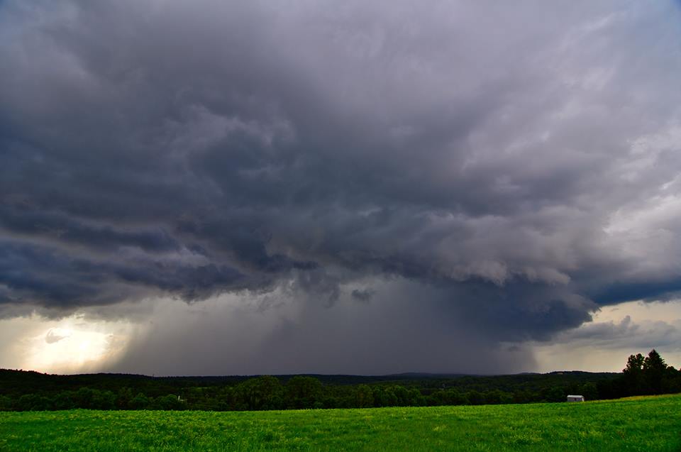
A tornado-warned storm as viewed from Charlton by Chad Whitlock on Monday as it moved toward Spencer. No tornado touched down with this storm.
That TV guy/gal...
The final communication cog in all of this is us, the television/radio Meteorologists that spread all this information to the general public. Whenever the weather is expected to rock, we're all sitting in our weather offices tracking the storms, following the warnings, wearing our microphones, and ready to jump on air if a tornado warning is issued. And much to the chagrin of Judge Judy fans - we will always stay on during tornado warnings. We frequently get the 'I'm changing stations!' email from angry viewers because of this, but I can promise you that every station worth a salt will go on and stay on during a tornado warning. It's the most dangerous type of weather we deal with because of its ability to destroy property and lives within seconds, all happening in an instant. There's no planning for it like a hurricane or nor'easter. The situation is also dynamic and changing...which is why we have to stay on. A storm could quickly tighten up and produce a monster, or dissipate into nothing within minutes. The most responsible thing we can do is to stay with it until the threat is over.
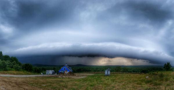
A massive shelf cloud barrels through York County, ME on Monday night. Courtesy: Rob Wright
Confirmed tornado before the survey?
Many were skeptical when we didn't wait for NWS to say it was a tornado, but you should know that radar now leaves us little doubt in these types of instances. That's why we can say with confidence that it was a tornado long before survey teams arrive. The survey itself becomes an exercise in the exact width, path, strength, and impact. The reason for this is the new breed of radar called dual-pol. It has a suite of products that never existed for us before (like correlation coefficient). When we look at that scan, plus base reflectivity and velocity products - we get a better look into these storms than ever before. This is also a major reason why you're getting more tornado warnings - Meteorologists are seeing potentially tornadic storms earlier and more clearly than they have in the past.
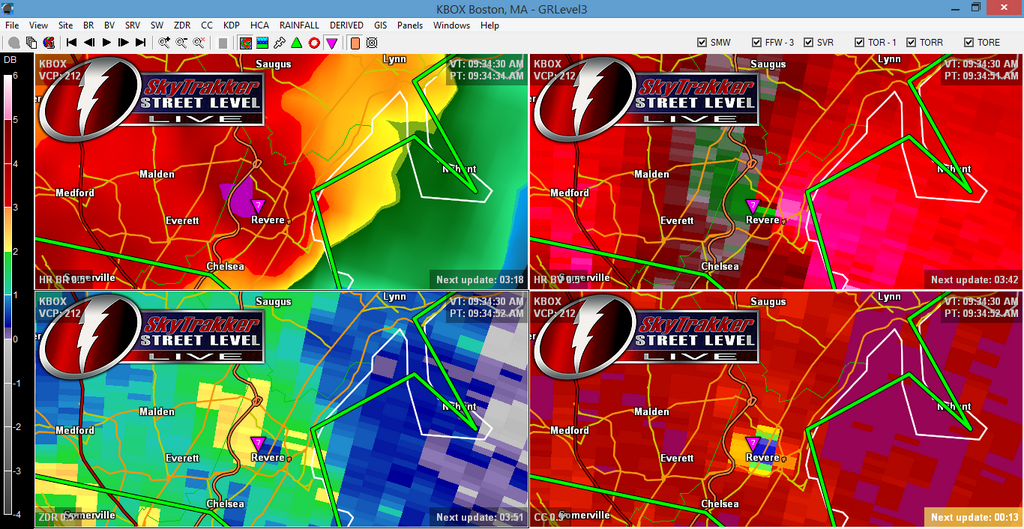
Series of radar products via @JamesSinko on Twitter. The two scans on the right are most telling. They show a tight velocity couplet (Upper right, where winds are moving quickly inbound/outbound over a very small area) and a low correlation coefficient (Bottom right). The CC donut hole is referred to as a 'Tornado Debris Signature.' At this point, radar is showing us debris being thrown around inside the tornado.
The tornado itself - a rare event!
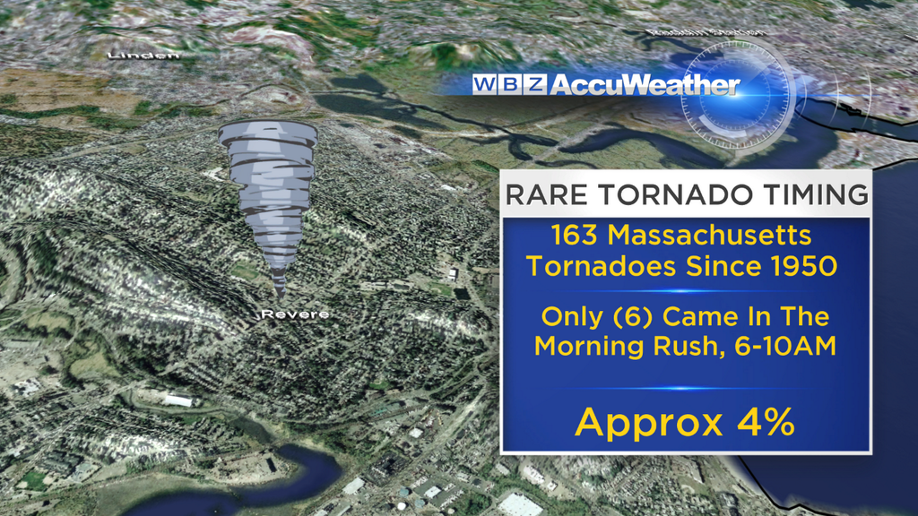
Severe weather records don't go back all that long - not nearly as far back as temperature data or hurricane reports. The reliable ones date back to 1950, a mere 64 years. Not exactly a huge sample, but it's what we have to work with. And in that database, 163 tornadoes have been recorded here in Massachusetts. Only 6 of them have come during the morning rush, which I'd call 6am-10am. So you're talking less than 4% of all Massachusetts tornadoes coming within that time! The last time we had one spin-up during rush hour was on September 16th, 1986. It's quite rare to have a tornado in this state come through at such a time of day.
On top of that, Suffolk County is a complete stranger to tornadoes. It is an admittedly tiny target so far as counties go, but Monday's twister was the first ever recorded in Suffolk. You always here the 'I've never seen this before' sound byte from survivors, but in this case it really was true! It's likely no one in Revere has ever witnessed a tornado in their city.
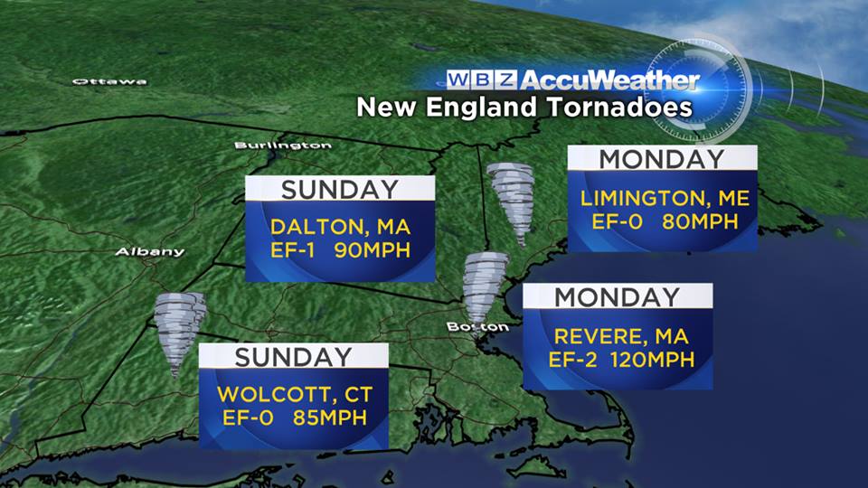
The Revere tornado and the June 2011 Springfield tornado are the two strongest to have formed in the state in this young century. Overall the state averages 2-3 per year (there were two last year - one in Stoughton and one over the Quabbin Reservoir). We've got to break down the myth that they don't happen here! It's not Oklahoma, but it is an annual risk.
Not alone - a wild 36 hours in New England
During the afternoon on Monday - a tornado was confirmed to touch down in Limington, ME (York County). Many of the storms were rotating all day long across the region since the there was ample wind shear in the environment. The previous evening, two tornadoes touched down in the area. One ripped through the woods in Dalton, MA (Berkshire County) and another was caught on camera rolling through Wolcott, CT. None of these tornadoes lead to any deaths.
I could go on and on about this, but I'll cut it short for now! Any questions at all, feel free to ask in the comments section below and I'll do my best to get to them.
Glad everyone is safe,
E