Increasing Severe Storm And Flood Threat
Find Eric Fisher on Twitter and Facebook
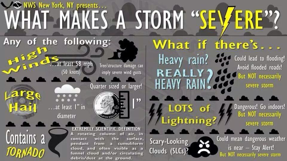
Great infographic from the National Weather Service out of New York
I saw this infographic posted by NWS New York yesterday and thought it provided a lot of information that Meteorologists often take for granted that everyone knows. Of course, MANY people don't know that a 'severe storm' has specific criteria (through no fault of their own). Meteorologists in general, especially those not in the broadcast sector, tend to be, well, geeky. We use technical words, some deep science, and often forget that - wait a minute - no one knows what the heck we're talking about! Read any Storm Prediction Center or NWS forecast discussion and you'll see what I'm talking about.
In any case, yes there are specific things about a storm that make them 'severe' - and that's when you get a Severe Thunderstorm Warning. Scary clouds, a lot of rain, vivid bolts of lightning - none of these factor in. It may be a flawed system for impact, but this is the way it works for now. And I do anticipate we'll be seeing a few of those warnings posted over the course of today and tomorrow.
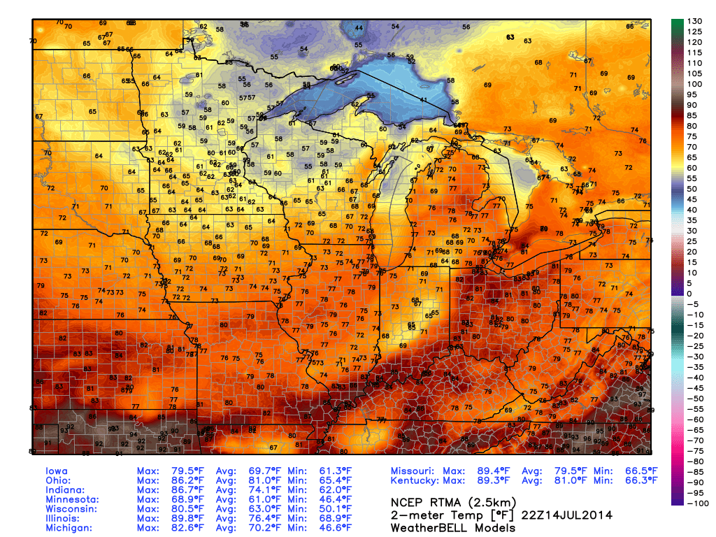
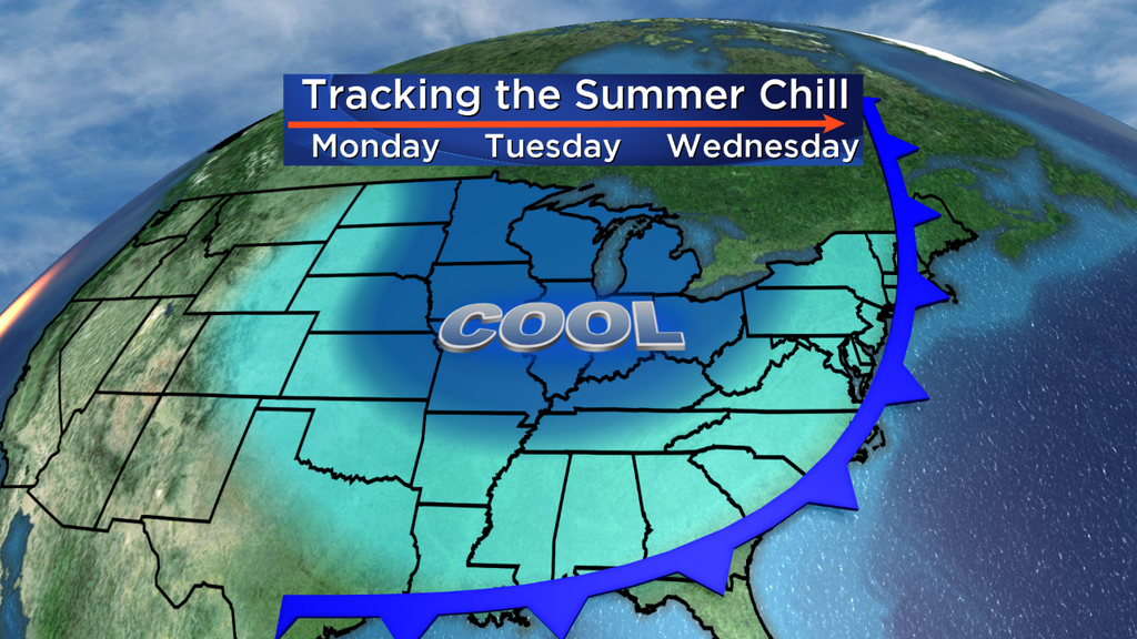
The instigator for a lot of our active weather this week is a massive plunge of very chilly air by mid-summer standards. On Monday afternoon, many Upper Midwest towns were in the 50s! Great for leaf peeping, except for the fact that it's typically the hottest time of the year right now. Minneapolis saw a new mark set for the coldest July 14th ever recorded - a meager high temp of only 65º. All the MLB players showing up for the All-Star Game may have it confused for the Fall Classic instead. This bulge of chilly air will reach all the way to the deep south by Wednesday afternoon, where it will arrive as a refreshing break from sweltering summer heat.
However, none of that chilly air gets to us. In fact, we're living on the edge between that cool air mass and hot, humid air near the East Coast. Where air masses clash, you get storms. And that's the case through Wednesday. The cold front - leading the charge for all this cool air, will slowly push in and won't get all the way through until early Thursday morning.
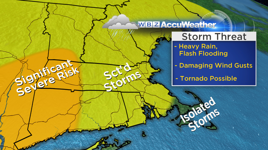
Here's the thinking on where the highest risk will be today. There are still some question marks as to how much sunshine will break out across the area today with a very soupy and humid air mass in place. But there should be enough instability to work with to get storms fired up during the afternoon and evening. Dew points will be into the 70s, and air temperatures should be in the 80s. That should generate at least 1000J/kg of CAPE, with potentially much more if the sun makes enough of an appearance. Plus, wind shear levels are significant as the deep trough to our west draws near. When you put the ingredients together, we may see several supercell thunderstorms develop - capable of producing large hail and perhaps even tornadoes. This risk is highest near the CT River Valley and points west into the Hudson Valley. The risk for strong/severe storms is lowest for far SE Mass, but certainly is not zero. I just wouldn't expect widespread coverage of any showers/storms on Tuesday.
There is a risk for more scattered severe storms across the rest of the area, but it will be far from a rainout. I don't think everyone will end up getting a storm out of this, but the ones that develop could really pack a punch. Even if we don't get a tornado or large hail, there's certainly a high risk of torrential rain and flash flooding with anything that pops. It'll be a good day to keep an eye on the radar and have a good weather app (like ours for iPhone, found on this site) to make sure you're wary of changing conditions.
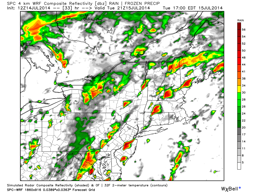
NSSL WRF projection for 5pm Tuesday afternoon. This model has a particularly nasty look to it, with several discrete supercells forming in the warm and unstable air mass. Source: WeatherBell
As we head into Tuesday night and Wednesday, a different setup starts to take shape. A strong jet-max will be rounding through the deep eastern trough, and we'll end up smack-dab in the right-entrance region of the jet. That's an area where air loves to rise and diverge aloft, spreading out and helping to force more ascent in the atmosphere. Basically, all that humid and moist air will want to rise - which means a heavy rain threat for us.
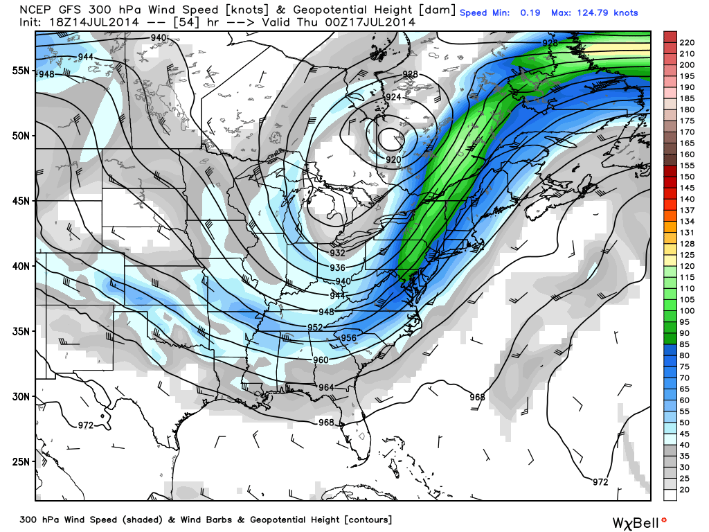
GFS forecast for 300mb winds on Wednesday. Source: WeatherBell
The whole East Coast will have an 'atmospheric river' of tropical air, stretching from the Gulf Coast all the way up to Nova Scotia. In essence, the air will be jam-packed with moisture ready to be squeezed out. Flash flooding has already been a problem in spots on Monday, and will again be an issue on Tuesday. The threat continues on Wednesday as the front lines up with the coast, and we're included in that. There's a good chance that between Tuesday and Wednesday, much of the area may see 2-4" of rain - and there's a chance that some could see even more if downpours train over the same areas.
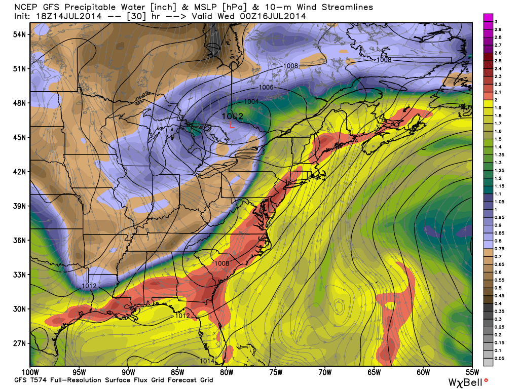
Precipitable water values will be very high (<2") for much of the first half of the week, including Wednesday. Source: WeatherBell
As it stands now it looks like the highest rain risk will be Wednesday morning through the early afternoon, before it shifts farther to the east. It'll be more toward the early afternoon through Wednesday night for the Cape, Islands, and South Coast. This is where the flash flooding risk will be greatest, since we'll already have gone through a few rounds of soaking storms and the rain on Wednesday should be more widespread in nature. We'll be keeping a close eye on it for you - but be prepared for the potential of very heavy rain an the complications that go along with it (poor travel, small stream flooding, etc)
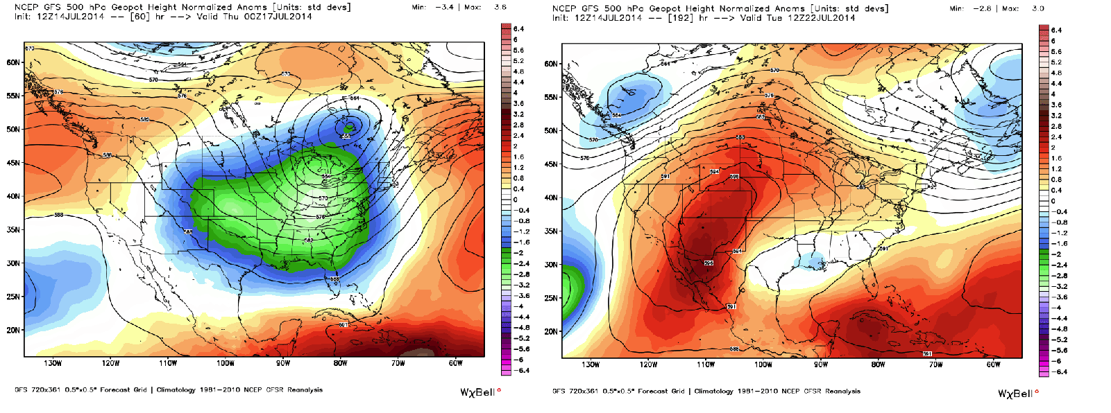
All of this comes to an end by Thursday morning, when less humid air takes over and the front heads out to sea. We'll still be underneath the jet stream trough, so a lot of cumulus may pop up on Thursday. But overall a pleasant one with highs near 80, and more sunshine will come out for Friday. Early indications are for a pretty pleasant weekend before a shower risk returns early next week. In fact, the whole pattern may shift in the middle of the Nation next week - going from a major trough to a big fat ridge bringing heat and drier weather for many. At this rate - it doesn't look like that ridge will get here though. The trough may dominate into August - meaning no real major heat to deal with and the overall pattern staying pretty active.