Walking The Line To End The Week
Find Eric Fisher on Twitter and Facebook
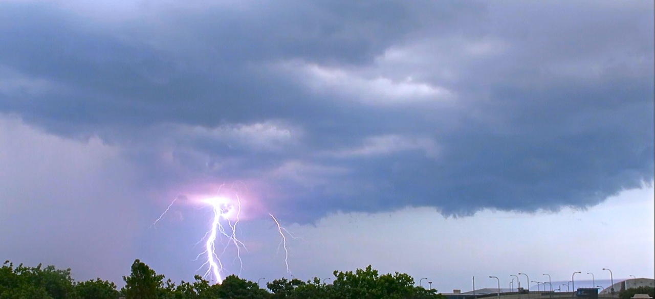
A blast of lightning strikes the ground on Monday evening near Lynn. Photo courtesy: Scott in East Boston
It has been quite the stretch for New England weather. Last Thursday - widespread severe storms and even a tornado warning in Rockingham County. On Friday - waterspouts on Lake Winnipesaukee, a Flash Flood Emergency with a summer's worth of rain in a few hours, and an extremely rare early July hurricane passing just a few dozen miles off the coast of Nantucket. On Monday - funnel clouds, a powerful microburst packing 100mph winds in Bedford, and tornado warnings through the afternoon. Needless to say - it was nice to take a break on Tuesday! While New York and Pennsylvania were getting pounded by severe weather, we lucked out with only lighter and more scattered fare during the late evening. I thought this would be a good time to talk a little about some of the differences between the setups and why some days deliver severe weather and others do not.
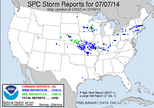
Monday was a busy day for severe weather from the Plains to New England, with multiple disturbances rounding a large cyclone in southern Canada. Source: Storm Prediction Center
On Monday - conditions were there for storms, but the potential for severity was subtle. It seems that most of our tornado warning days come with situations like this. (Somewhat embarrassingly) for the SPC, we were not even in a Severe Thunderstorm Watch on Monday while all this was breaking loose. It was a rare miscue from the agency that issues all Severe/Tornado Watches, which often does a spectacular job. They have actually admitted in the past that their expertise is somewhat limited in New England, as our severe weather can be a little more nuanced and hyper-local than it is across the Plains or Midwest.
We had some CAPE (instability) to work with on Monday - about 1000-1500 J/kg. That gets your attention in New England, but isn't wow-worthy. There were about 30knots of shear, which means the potential was there for rotating storms. Again - enough to work with, but not spectacular. And we had some heat and humidity, which plays into those CAPE values (highs well into the 80s, dew points well into the 60s). But even with these conditions you need a trigger. The 'trigger' is some way to force the air to rise, giving life to storms. Without anything to force that air up, it's tough to get things going. Well on Monday, there was a little short-wave (a small vorticity max) that came through our area. That's all it took. Boom and the rest is history.
As for the microburst - here's a great example of how straight-line winds can be just as damaging as some tornadoes. NWS survey teams came out on Tuesday and determined winds reached 100mph in Bedford! That's equal power to an EF-1 tornado, and not too far away from EF-2 status (111-135mph). So while tornadoes always grab the headlines and are much more visual, there are plenty of other ways nature can make a mess of your yard and property. Not to mention the thousands of cloud-to-ground lightning strikes that blasted their way through the area on Monday.
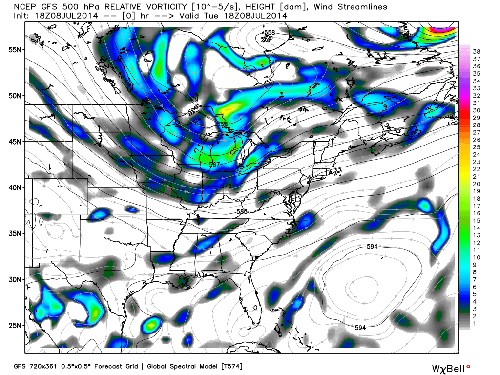
500mb vorticity analysis on Tuesday afternoon. Not the energy heading toward New York and PA, but nothing in New England to get storms going. Source: WeatherBell
So what changed for Tuesday? Oddly, the instability parameters were even more impressive on Tuesday than on Monday. Temps were warmer by a few degrees, and dew points followed suit. There was more wind shear to work off of, meaning there was the potential for storms to rotate. But what was missing? The trigger. No short-wave was present to move through New England and force the warm and moist air upwards, and no cold or warm front was nearby. A much more powerful short-wave plowed into the interior Northeast and produced a large line of severe storms in New York and Pennsylvania, and we were too far east to see the significant effects of that line (fortunately!).
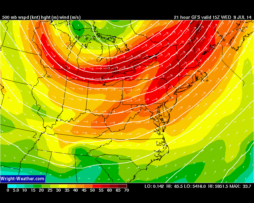
500mb wind maximum will be swinging through New England on Wednesday. GFS model pictured, via Wright-Weather.com
And now we look at Wednesday. It's another day of tricky storm forecasting, as we'll be walking a line between 'ready to go' and 'nada' during the afternoon. A cold front will likely be located right through western New England, with more very warm and moist air in front of it. Dynamically, the atmosphere looks ready to take off. We'll be in a favorable region of a mid-level wind max, we'll have more jet stream energy to help vent the upper levels. Temps will be well into the 80s in eastern MA, perhaps even touching 90. And dew points will be in the 60s. But this time we are missing a different ingredient - moisture. A lot of drier air will be moving in above our heads, which may limit updrafts and keep thunderstorms in check. Most models are not predicting a very busy day of storms. However - it's a day to stay very vigilant. *If* things can come together and develop during the afternoon, there will be wind shear to work with and these storms could go severe rather quickly. While the SPC does not have us in a risk area at the time of this writing, I would not be surprised to see them pop and there's even an outside shot of more rotating storms capable of putting down a tornado. So just stay weather aware, check in for updates, and you know we'll be on the radar all day in case things kick off!
For Thursday and Friday that front will finally push offshore, but it will not go willingly. It's expected to just barely shove off the coastline on Thursday, perhaps keeping clouds and a few showers in play across the Cape/Islands/South Coast. On Friday it will still be extremely close to our shore, so we'll have to watch to see if it tries to move back up in our direction. The vast majority of the area looks great (WMass, Worcester County, southern NH, Essex County, and most of Middlesex)....air will be dry and skies will be bright both days. But if you live in SE Mass, be warned that clouds may try to crash the party to end out the week. For now, we'll call is partly sunny and less humid.
High pressure takes firmer control of the situation on Saturday, which looks excellent. By Sunday the next piece of jet energy may bring us some late day storms, but for now it definitely does not look like a washout. Overall another pretty good weekend is shaping up, before very stormy conditions return to begin next week.


