Hurricane Arthur Soaks Southern New England
BOSTON (CBS) - Not exactly how you envisioned spending the 4th of July when you asked the boss for the day off back in the dead of winter right?
I am sure that watching the local weather forecaster track a hurricane making a dangerously close pass to southern New England wasn't on your agenda.
Download: CBS Boston Weather App
Well, sadly this one isn't going out to sea. Hurricane Arthur is coming this way and will likely pass within 50 miles or so east of Nantucket Friday night.
If that sounds too close for comfort, well, you are right, it is!
Check: Tracking Maps | Current Conditions | Interactive Radar | WBZ Weather Blog | Forecast Maps
The good news - the strongest winds are almost always located on the east side (right hand side) of hurricanes and Arthur will be no exception. That means the hurricane force winds should stay well out to sea.
Related: Flash Flood Emergency On South Coast
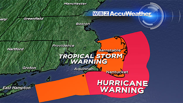
The bad news - the heaviest rain is almost always on the west side (left hand side) of hurricanes and that puts a bulls eye right on southern New England. While it will be highly variable, some areas could receive 2-to-4 inches of rain or perhaps locally even some higher amounts.
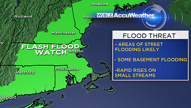
We are not in danger of any major river flooding, but flash flooding in the streets and poor drainage areas is almost certain.
Let's break this down hour by hour:
Afternoon: (Up to 5 p.m.)
The first bands from Arthur are spiraling in along the South Coast, kicking off the downpours. As the afternoon wears on, these bands will make northward progress and the heavy rains will move from southeastern Massachusetts up to Boston and the northwest suburbs.
By 4 or 5 p.m. I would expect that most everybody in central or eastern Massachusetts would have gotten wet.
Evening: (5 p.m.- 8 p.m.)
This is when the peak of the storm and heaviest rain will begin.
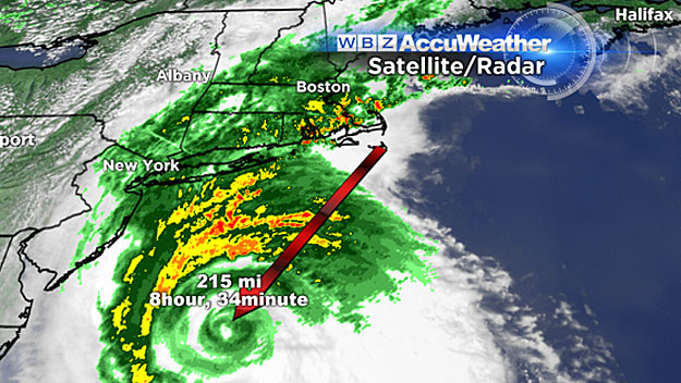
Arthur will begin to accelerate, moving quickly from the Mid-Atlantic waters towards Nantucket. Bands of torrential rain will rotate into southern New England from south to north, enveloping all of Massachusetts, southern New Hampshire and Maine in shades of dark green, yellow and reds on the radar. Some lightning or embedded severe weather is not out of the question. Localized flash flooding is also likely.
Night: (8 p.m. - 5 a.m.)
Arthur makes its closest pass, within 50 or so miles southeast of Nantucket around 10-to-11 p.m.
This is when the winds will be peaking, gusting 40-to-60 mph on Nantucket and the outer Cape. In southeast Massachusetts and up to Boston, winds may gust 20-to-40 mph as the storm passes, veering from east-northeast to north and then northwest. Rain will come down in sheets and widespread flash flooding is likely. However, around about 2 a.m., the rain will begin subsiding and Arthur will pull away, heading for Nova Scotia in a hurry. By the time dawn hits and folks start waking up, the sun will already be emerging.
Weekend:
Here is the really good news - a tremendous weekend ahead!
Plenty of sunshine, temperatures in the 80's and low humidity. A bit breezy on Saturday, but truly a terrific weekend to be at the beach, with one caveat.
Please be aware of big waves and rough seas.
If you have plans to be in the ocean, swimming or boating, check out the forecast and take caution.
Rip currents will be a major concern, especially on Saturday.
Follow Terry on Twitter @TerryWBZ
MORE LOCAL NEWS FROM CBS BOSTON