The Holiday & Arthur - A Hurricane Approaches
Find Eric Fisher on Twitter and Facebook

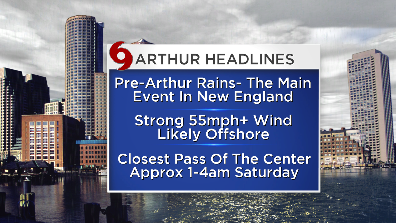
A lot of people have been asking - isn't it weird to have a hurricane around here at this time of year? The answer - yes! Alert me if I've made a clerical error, but I cannot find a single hurricane ever making landfall before August in New England. Now I'm not expecting Arthur to make landfall, but it may come very close to Nantucket and I wouldn't completely rule it out as nature has a way of surprising us. There have been a handful of tropical storms, subtropical storms, and the remnants of tropical systems this early - but not a system powerful enough to be called a hurricane. We'll see where Arthur lands in the record books, but surely it doesn't hurt that water temperatures are WAY above average in its path and should keep it from dying out as it makes a close pass with New England.
With that said, the immediate conclusion from many is 'oh great...a rare storm on the 4th of July.' Yes, the timing is not on our side, and a lot of festivities have already been canceled and moved around. This is the bane of a Meteorologists' existence - forecasting significant weather for holidays. Not a good way to win many friends.
In any case, let's get to it as we all have fireworks, bbqs, brews and beaches on our minds. And while there will be some rough weather to deal with there will also be a great weekend to follow.
 Arthur satellite loop
Arthur is currently off the southeast coast, and has been strengthening over the past 24 hours. The only real thing hindering it is an area of dry air in its surrounding environment, getting ingested by the storm and keeping some of the thunderstorm activity at bay. Otherwise, wind shear is favorably low and the water is toasty warm in the 80s. The dry air should start to erode somewhat over the next 24 hours, and so Arthur should absolutely become a hurricane. In fact, I will not be surprised if it strengthens up to a Category 2 hurricane tomorrow.
It will lash the coastline of South Carolina with rain bands, and move up to North Carolina by the afternoon. Its first landfall is expected to be on the Outer Banks - something you roll the dice with if you vacation on that beautiful strip of beach in the summer! Many evacuations are underway, with some unhappy vacationers and locals hitting the road. Storm surge of ~3 feet, hurricane force winds, and heavy rainfall will impact that area through early Friday.
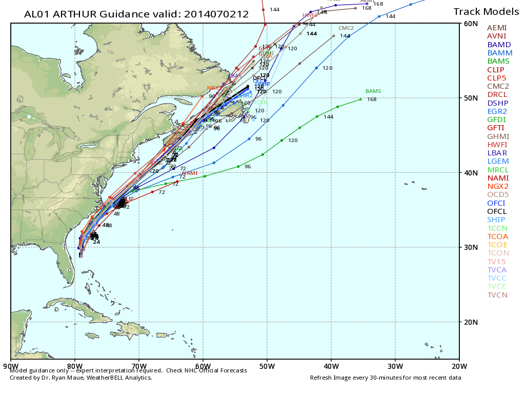
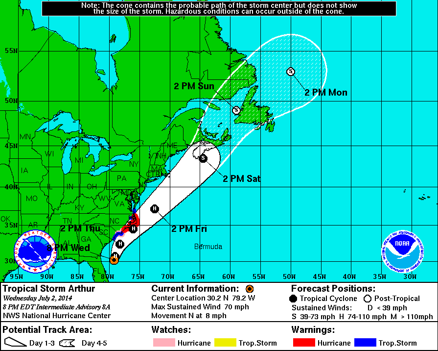
Above are two different plots. The left, from WeatherBell.com, is a 'spaghetti plot,' aptly named because they often look like spaghetti. The other is the official NHC forecast as of 8pm Wednesday. While model consensus is on a track out to sea, there are still a couple close enough to raise an eyebrow for us in Massachusetts/Rhode Island. And I want to point out that the official NHC forecast still has Massachusetts in its 'cone of uncertainty.' The cone is just that, developed the indicate the range of possibilities outside of the official forecast. One thing with nature - never believe for a second that it's going to behave by our rules. I *do* think Arthur will miss Nantucket to the SE, but it's not completely out of the question that it could track a little farther west. We'll have to monitor the storm carefully because of this - especially since a few models jogged a little farther westward with their forecast today.
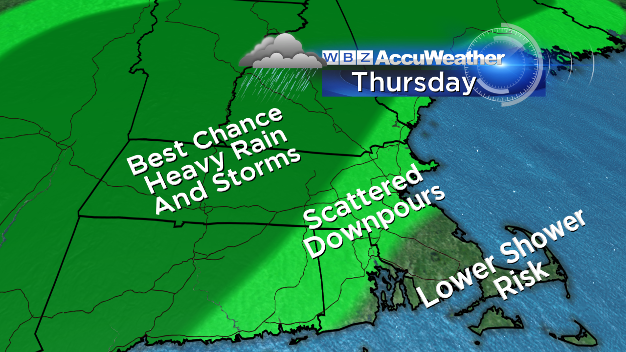
Here's how I think Thursday will break down in terms of rain risk. People are asking why change the Pops concert in Boston, and the answer is that Thursday is the lesser of two evils (and Saturday was not an option for the performers). While there is still a risk of scattered showers & storms on Thursday, it's not expected to be a solid shield of downpours. However, that situation may unfold Thursday afternoon/evening across western New England and perhaps even bleed into central Mass. So there will still be many July 3rd celebrations impacted by the weather in a very warm and humid environment. Not a whole lot changes in the setup on Thursday compared to what we saw today, except that the front focusing all this moisture moves a little farther east. If you're not seeing rain, expect an extremely sticky day with dew points in the 70s and temps well into the 80s! So bring water and rain gear if you're headed toward the Boston esplanade.
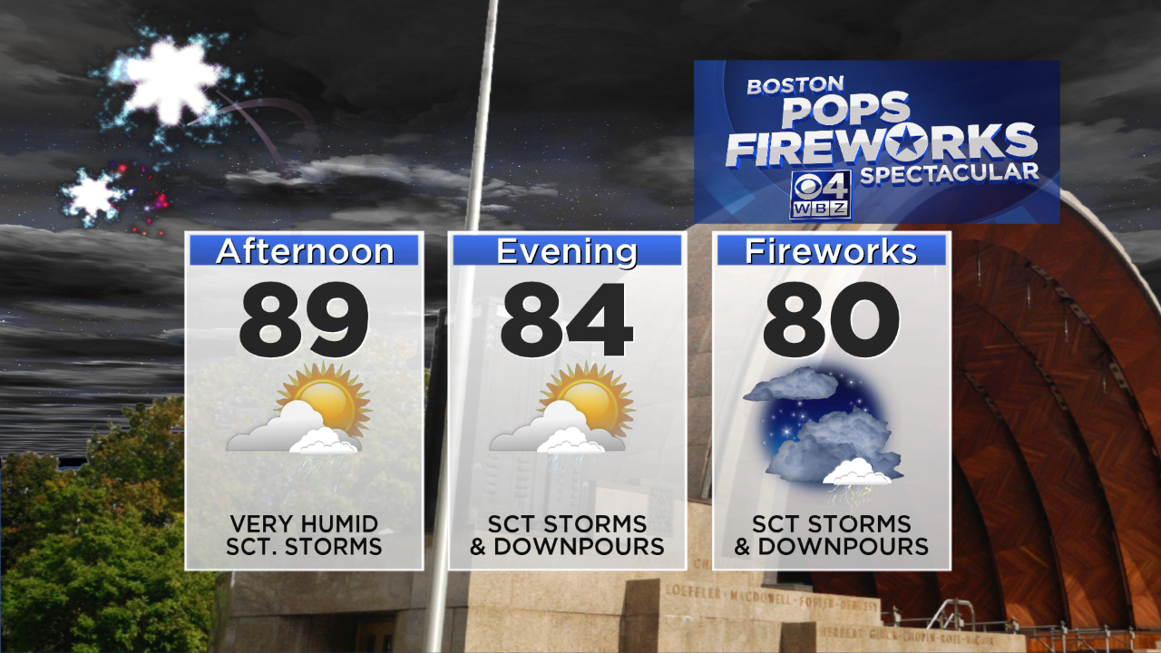
Then we get to Friday, and here's where the setup changes a little. A jet max will be moving in from the west, while Arthur moves a little farther north as a stronger storm and the cold front focusing its moisture jogs just a little farther east. All told - what that means for us is that the heavy rain potential will go up.
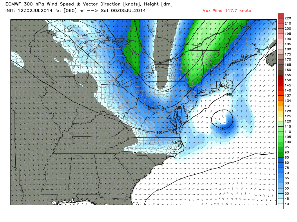
Above is the main reason I'm pessimistic about Friday. We'll be smack dab in the right-entrance region of the jet stream, which is a place where air 'diverges' aloft. In essence, this helps to force air to rise and vents it out as it does so. Considering we'll have plenty of moisture available from Arthur to the south, this should help generate a pretty good shield of tropical downpours. These may start up in the morning, but should really get going heading past midday and into the evening. As it stands with the current track, the highest chance of heavy rain will be eastern Massachusetts, in particular from I-495 eastward. I don't have a lot of optimism that 4th of July plans are going to go on without issue Friday evening. Wish I could say the opposite, but unless something significant changes with the track I'm not sure I see a way out of it.
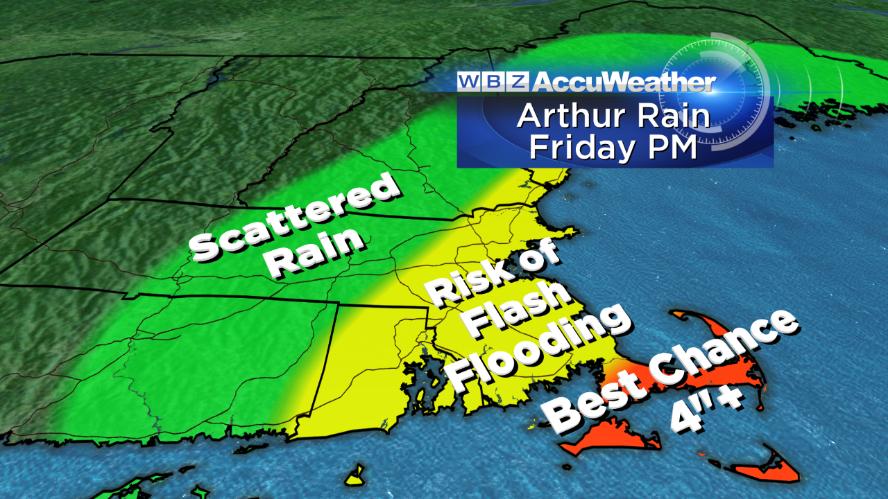
This is an early estimate of rain totals, and if the heavy rain I think is going to develop comes to fruition, we'll probably have some localized flash flooding concerns in far eastern Massachusetts Friday evening and night. There's a pretty decent chance parts of the Cape/Islands could see 2-4" of rain, and there's definitely a shot at 4"+. Tropical rain bands can deliver a lot in a short amount of time, and I think we'll need to keep our eye out for those kinds of totals.
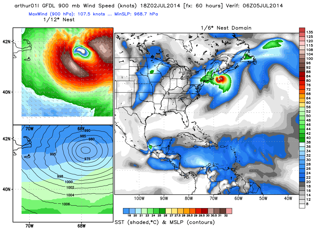
GFDL model for 2am Saturday morning. Courtesy: WeatherBell
As for wind, right now I don't think it'll be a big issue for us. Above is the latest GFDL model, showing the strongest core of winds staying offshore. Like I mentioned above, there's always some inherent uncertainty with these beasts and a track farther west could be a game changer. What I'm going with now is a good likelihood of tropical storm force winds briefly hitting Nantucket and the Outer Cape Friday night into early Saturday morning. Most gusts should stay under 55mph, and with winds like that we wouldn't expect much, if any, damage. Will monitor this for any possible changes.
So in short, Arthur for us is more about rainfall and putting a damper on holiday plans than wind or surge. Every storm is different in what it brings to the table. I think the most impact we'll see is from flash flooding and some difficult travel on Friday into early Saturday morning. There may be some flight delays and cancellations, especially considering it's an East Coast storm and there's always a trickle down effect from what's happening elsewhere. But the good news is that it will depart with the final rain bands exiting by early Saturday morning, and we're on to a great looking weekend. Saturday should be in the 70s to near 80 with a gusty breeze and bright skies. Sunday will be in the 80s with low humidity and a frisky westerly breeze. Overall we'll have 2/3 great days for the 4th of July holiday weekend - just watch out for rip currents at the beach!
On Thursday,