4th Of July Fireworks Forecast: Tropical Downpours Possible Thursday, Friday
BOSTON (CBS) - The 4th of July forecast is typically a fairly simple one. There are usually only two concerns with the weather this time of year - will it be oppressively hot and humid and will there be a thunderstorm?
Download: CBS Boston Weather App
We have certainly had our share of both in recent years. On July 4th 2013, temperatures peaked at 94 degrees, the second day of a five-day heatwave in Boston. In 2012, the entire Esplanade had to be evacuated due to a nasty thunderstorm and frequent lightning just a few miles away.
Sure sounds like we have seen it all in the last few years, eh?
Not exactly.
Check: Current Conditions | Interactive Radar | WBZ Weather Blog | Forecast Maps
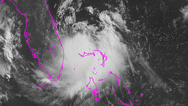
I am sure that by now you have heard, Tropical Storm Arthur is forming off the coast of Florida and, as luck would have it, will likely be making its closest pass by southern New England on Friday night, perhaps as a hurricane.
This may sound like just about the worst case scenario for the 4th of July celebrations. However, at this point we feel the chances for a dry evening are not only still on the table but perhaps as high as 50-50.
Check: Fireworks Displays | Pops Concert Webcast | Esplanade Guide
Let's back up just a bit and take you through step by step as there are many weather factors at play over the next few days.
THE HEAT
The buried weather headline of the day is the heat. Today will likely mark the first 90-degree day in Boston this year, nearly a month later than normal.
Along with the oppressive humidity, the "feels like" temperature Tuesday and Wednesday will be near 100 degrees.
THE RAIN
Next, a cool front approaches slowly from the Midwest late Wednesday and Thursday. This will be a trigger for numerous showers and thunderstorms, most of which will occur inland, west of Boston.
At the same time, Tropical Storm Arthur will be gaining strength and starting to head north, passing very close to the Outer Banks of North Carolina on Thursday. It may even reach minimal hurricane strength at this point (sustained winds of 74 mph or greater).
While this system will still be several hundred miles away from southern New England, some of its moisture will likely be drawn in by the cool front, enhancing the showers on Thursday, giving them a tropical feel. Some locations in western Massachusetts will receive several inches of rain. Closer to Boston, the rain will be more spotty, but some downpours cannot be ruled out.
WHAT ABOUT FRIDAY?
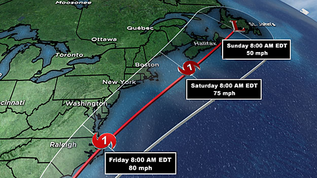
By Friday, Arthur will become the dominant feature on the weather map as it moves away from the Carolinas and towards New England.
At this point, we expect it to begin to veer more easterly than northerly and this is truly the key to this entire forecast.
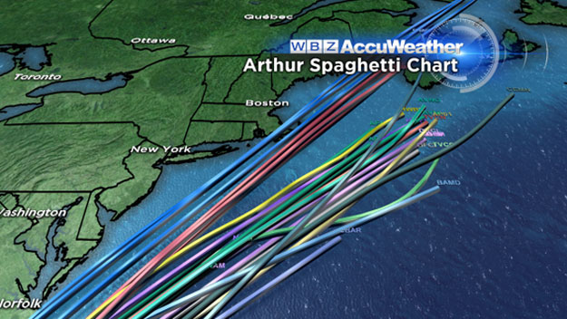
It is still too early to determine an exact track for Arthur.
The "cone of uncertainty" ranges from a direct hit on southeast New England (unlikely) to a complete miss a few hundred miles out to sea.
The truth will likely lie somewhere in the middle.
At this point, a track of about 50-to-100 miles east of Nantucket seems most likely.
While this seems awfully close, and it is, this track would spare us from just about any wind concerns from Arthur. Nantucket might be the lone spot to see tropical storm force gusts, up to about 40 mph.
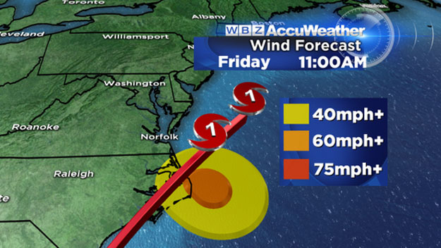
The biggest concern from Arthur would be the heavy rain.
As with most strong tropical systems, there will be some heavy spiral bands of rain extending out from Arthur's center. Southeastern Massachusetts, Cape Cod and the Islands would have the greatest risk of being affected by these torrential downpours. In Boston and points north and west, a much lower risk.
But again, this is all dependent upon the final track. Might we be spared from any significant rain and wind in Boston and nearby suburbs? Yes, but the stakes remain high with such a powerful system in our nearby coastal waters.
DANGEROUS BEACH & BOATING
Those with marine interests should pay close attention as well.
The seas will likely build quickly during the day on Friday. Regardless of how close Arthur passes, it will still churn up the seas and perhaps make some beach and boating activity dangerous right into the Weekend.
So the best advice we can give Today would be to stay tuned for updates in the next few days. Don't cancel any plans just yet, but starting thinking about a backup, and Saturday and Sunday look beautiful!
Follow Terry on Twitter @TerryWBZ
MORE LOCAL NEWS FROM CBS BOSTON