Gardens Rejoice! Rain & Warmth Ahead
It's bright and green out there now, but the growing season was off to a pretty slow start this year. Some fairly cloudy weather in May, along with cool nights and very little humidity, haven't exactly had the tomato plants leaping out of the ground just yet. But the good news is there's been nearly zero frost since mid-April, no major crop damage, and now the weather is definitely turning in our favor. The farmer's markets will be full of good eats before you know it (and they already have been when it comes to cold crop vegetables). My grill is looking forward to it.
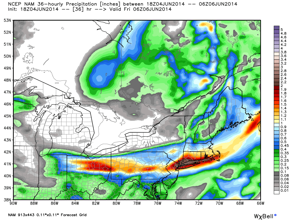
Wednesday 18z NAM forecast rainfall from this storm system. Source: WeatherBell
The rain comes first, an essential part of the equation if you don't want to rack up a giant water bill. Part of the energy which produced a lot of severe weather in the middle of the nation over the past two days will be swinging south of New England today. This system should have a fairly sharp cutoff on its north side between the haves have nots, but many of us are in line for some beneficial rainfall.
In terms of the steadiest rain it's looking like the 6am-3pm time frame, with the heaviest coming down late morning through early afternoon. Definitely want to grab the rain gear before heading out of the house or else risk looking very unhappy walking down city sidewalks. There isn't a ton of instability to work with, so not expecting much in the way of thunder. There may be a rumble or two mixed in at most. We're also on the chillier side of this storm, which should pass very close to Martha's Vineyard this afternoon. The onshore winds will keep temps in the 58-64º range. The rain should start tapering off by mid-afternoon from west to east, and by the time the workday is over most of the heavy rain should be over with as well (some showers may linger in its wake).
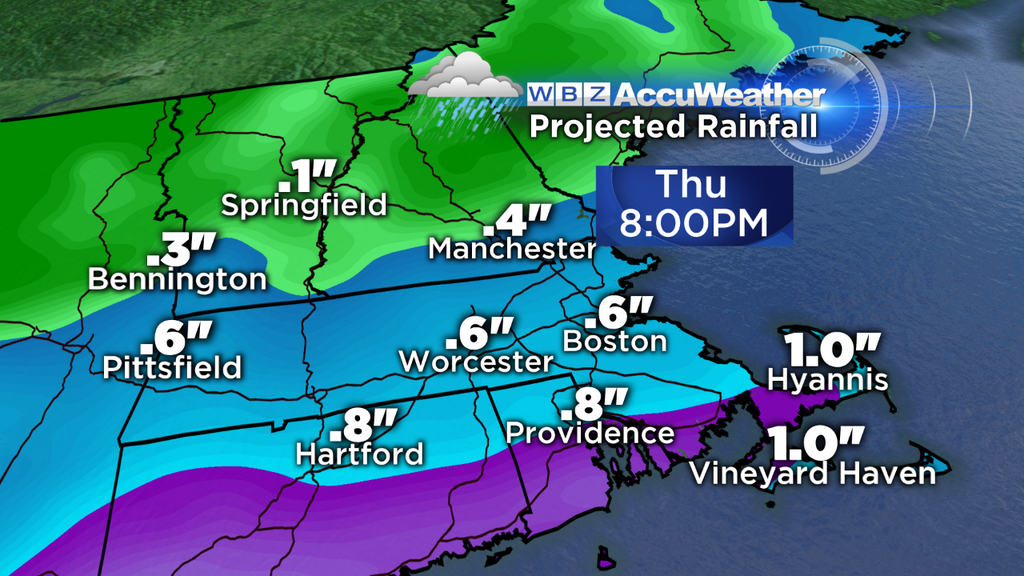
This is one model's output for rain totals, and I think it has a pretty good handle on the situation (give or take a couple tenths of an inch). Higher totals are expected along the South Coast/Islands/Cape which will be right along the warm front. A band of heavy rain should manage to soak this region with 0.75-1.5". But as you head north, the totals should drop off. Near and north of the Pike we're likely talking about close to 0.5" - good enough to keep the lawns and gardens happy. Into New Hampshire much lower totals are likely as the precip edge will be ragged and the rate of rainfall should be lower. Still *some* rain, but not the soaker expected farther south.
As we head onward toward the weekend, we'll kick the chilly stuff outta here and bring back the warmth. Friday is the transition day, as an upper low will still be nearby and a shower risk will remain. Definitely not a washout day, but some scattered showers are likely in the cyclonic flow. Other than that, partly sunny skies and highs in the 70-75º range. If you have any Friday evening plans, any showers that develop in the afternoon should diminish.
Then we come along to Saturday/Sunday, and so far we're still on target for a beauty. A cold pool aloft will still reside over New England on Saturday, although nothing too impressive. Just cool enough to promote some scattered cumulus clouds, and the slightest chance of an isolated shower/storm. I think the vast majority of the area will be dry and warm though, with highs in the 70s to low 80s.
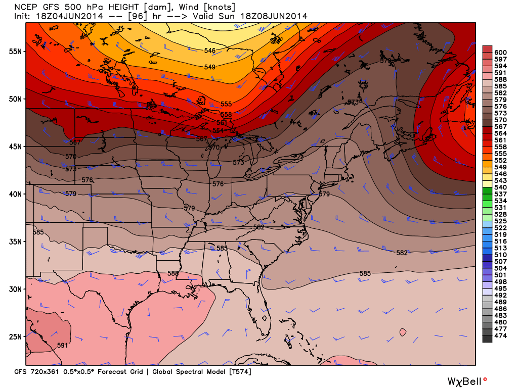
500hpa ridge parked right over the Northeast on Sunday, says the GFS. Source: WeatherBell
Sunday looks even better as a ridge crests over the region and the atmosphere continues to warm. We're talking widespread 80s and loads of sunshine - beach day! Of course, it will be a little cooler at the ocean as it often is this time of year. But with all that sun and generally warm temps it should be a great day for beach and boating - not to mention the myriad parties, BBQs, weddings, etc.
Could it be a Top 5 weekend? Well I'm writing this late Wednesday night, and we all know certainly forecasts can change a few days out around here. But if things hold, we get a couple of dry and bright days near 80, and there's very little humidity? I don't know about you, but I can't count too many weekends that feature that in a given year in the Boston area. So fingers crossed that Mother Nature throws us no curve balls and we all can soak in a glorious first full weekend of June.