May Ends On A Chilly Note
Find Eric Fisher on Twitter and Facebook
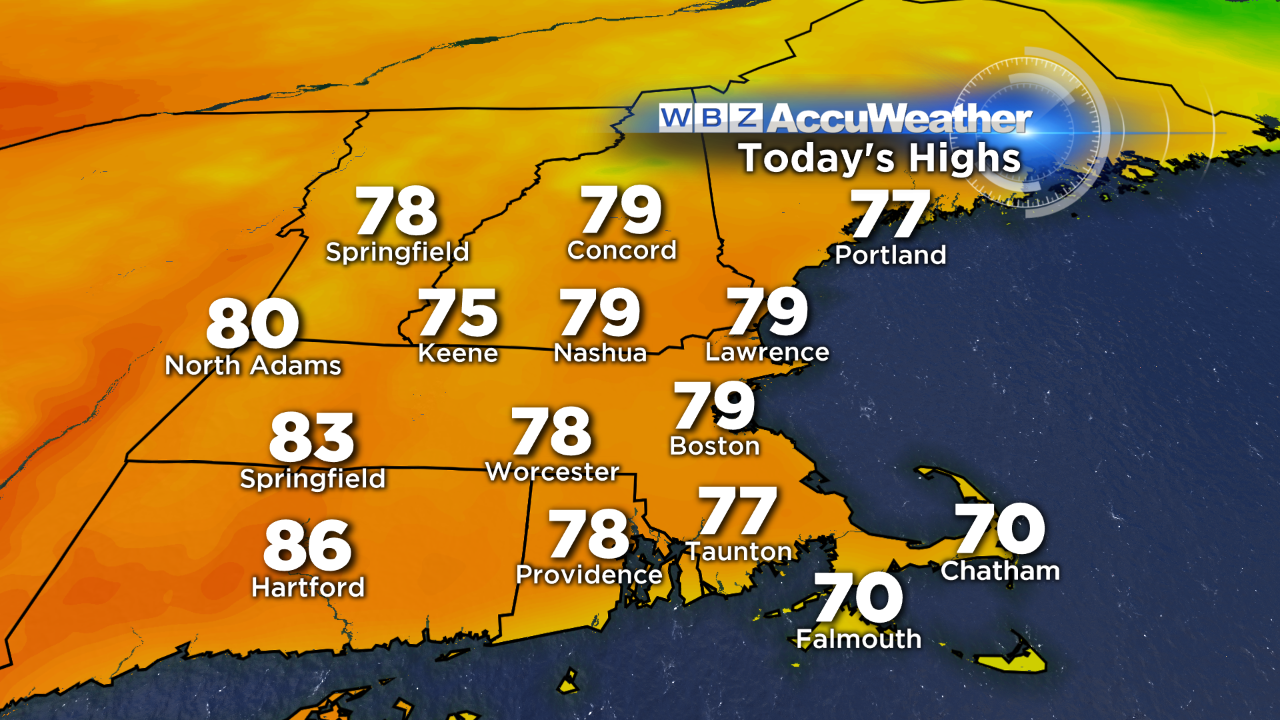
Observed high temperatures on Memorial Day. This is likely to be the only day of above average-temps in a stretch that otherwise would extend at least 11 days! The heat has been tough to come by so far this year.
Warmth we had. The sun, we did not. So let's clear the air to kick off the blog today - Memorial Day was obviously not what we had hoped for. The cloud/shower band that was expected to be about 40 miles farther north decided to set up on top of us instead. So I won't mince any words - I apologize for the surprisingly gray weather that persisted all day. While we as Meteorologists expect a few days every year are definitely not going to go our way (workplace hazard predicting the future), we still are miserable when it happens and always strive for accuracy. It's even worse on a holiday. I hope that you all still managed to observe Memorial Day, and enjoy time with friends and loved ones. When you get chucked a curve ball either in weather or life, you just have to put on a positive face and roll with it. I know I still had a great picnic and walk on the beach with friends, albeit grumbling at the gray overhead. If you did the same instead of sending us hate mail, then I salute you!
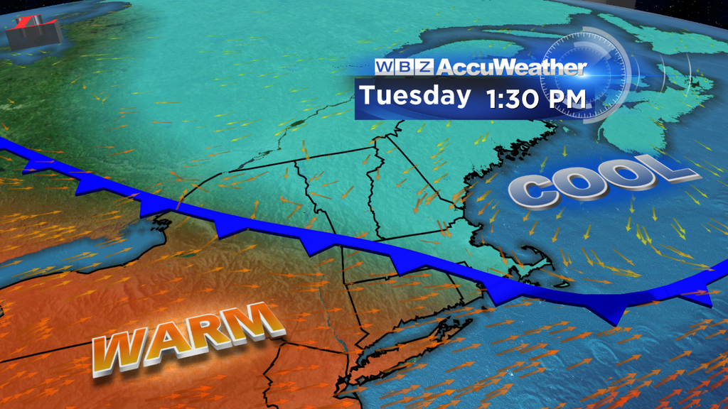
Onward we march, and that's funny...it's actually going to feel like March again today. Just deeeelightful weather we've been having, isn't it? While the morning will be starting off nice and mild, a potent backdoor cold front will be lurking just off to our northeast. This one is going to hurt, from highs near 80 on Monday to a blast of chilly ocean air moving in from NE to SW.
Here's the general timeline for today. First up - it's going to be mild out the door for just about everyone. The only exception to this may be the Seacoast area and Cape Ann, which will feel the chill before anyone else. Any mild air will be very limited in these areas, with most of the day in the low 50s with mist, drizzle, clouds, and a 10-25mph NE wind. Lovely.
The front should push through coastal areas around Boston and across much of the Cape by late morning, plunging temps from the 70s into the 50s. By early afternoon, it should have made progress past the 128 corridor and perhaps will have reached the 495 corridor. Its pace will be slowed somewhat by the huge basin of warm air to the west, but by the time you drive home it should be in the 50s across our entire viewing area. Those of you who will get to enjoy the warm air the longest will be in Worcester County, particularly southern Worcester Co., and southeastward through the Blackstone Valley. In fact, many towns will push 80º before the cold arrives! Lots of 80s are expected in WMass and Connecticut. But don't be fooled - everyone should bring some cold weather clothing before leaving the house in the morning, because it will feel a whole lot different by the time you leave the office.
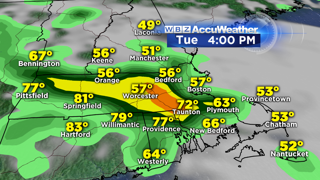
As for rain - we'll be dealing with that too. It should be more showery/drizzly in nature in the cold and stable air near the coast, but some decent showers may develop on the leading edge of the front as it heads inland during the late morning and midday hours, with some thunderstorms popping too as we head into the afternoon. Most of the storms will stay in the warmer air, so the highest risk of these downpours will be in Worcester County an down toward the Taunton/Mansfield area before the cold gets in. If the front slows down a bit, these storms may be able to work into Middlesex County. Any storms that develop could contain heavy rain, gusty winds, and hail. I'd plan on areas of very wet travel during the evening commute, especially heading out west on the Pike.
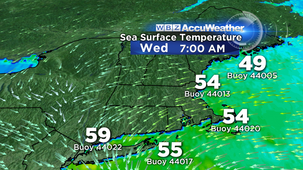
The buoy reports here are sea surface temperatures, which basically become air temperatures for us if there's a strong onshore flow. We've had a lot of these days so far this spring, that's for sure. They're warming, but not too rapidly since it hasn't been too sunny to help boost the water temps.
On Wednesday, a lot of low-level moisture will still be trapped across the region - so I'm thinking plenty of clouds through at least midday. There should also be some scattered areas of showers/drizzle in those clouds. Some drier air is expected to wedge down during the afternoon/evening, so some sunshine should be able to break out from north to south. Even with the sun, a stout onshore flow will keep highs generally in the 50s. The average highs for this time of year are in the 70s! Ugh.
Conditions improve for Thursday, but temperatures will still struggle to rise. The high pressure building nearby will help clear out the skies and provide lots of sunshine, but the lax pressure gradient means more sea breezes and highs near 60 along the coast, with low to mid 60s inland. That being said, Thursday is definitely my pick of the week if you want to get outside. It's the brightest day, and that late May sun feels good regardless of the temperatures. So if you want to sneak in a round of golf or mow the lawn in comfort, this is probably your best bet.
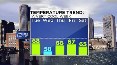
Looking out toward the weekend reveals more unsettled weather as another trough digs in across the Northeast, keeping all the warmth off to our west. A disturbance on Friday should bring a good chance of showers/storms, and with that temperatures mainly in the 60s (some low 70s look possible). The associated cold pool aloft will stay overhead on Saturday as a storm swirls nearby in the Atlantic. The models diverge quite a bit for the weekend, with the (miserably performing) GFS producing a much sharper trough that sticks around for longer, and the ECMWF (doing better, but not great) having a more progressive solution that kicks this storm out to sea faster. For now I'm leaning toward a cool and unsettled Saturday, with showers likely and highs in the 60s. We may be able to dry things out, brighten the skies, and get back to 'average' for the first day of June on Sunday. We'll have to see how this progresses as the week goes on. If the ECMWF is correct and we can get some ridging to build in for Sunday and Monday, it would be quite beautiful out with 70s and 80s by Monday for some, but unfortunately even if that happens I don't see it sticking around for too long. The ridge is progressive, and should yield to another bout of storminess by Tuesday. If you're looking for a long streak of 70s and 80s, it still looks pretty elusive going into June. However, there are some signs of a pattern shift that would allow for at least *some* warming up toward more summer-like levels by mid-June. I know it sounds far off, but there's still plenty of time to sweat it out this summer! Just getting some 70s with scattered 80s would be wonderful at this point.