Looking Ahead To The 2014 Atlantic Hurricane Season
BOSTON (CBS) - On Thursday, May 22nd - NOAA will release their outlook for the 2014 Atlantic Hurricane Season. My thoughts on outlooks are shared by a number of Meteorologists in the field - they have limited use. If you talk to someone in a 'quiet' season that's just been hit by the only hurricane of the year, I doubt they'd tell you it was 'quiet.' One is all it takes, and one destructive storm can change lives within hours. 1992 is the poster-season for this rationale. Only one hurricane made landfall - but it was catastrophic, Category 5, Hurricane Andrew.
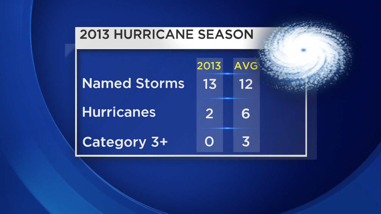
So what do we get from an outlook? Well it could just be an idea of how active the season will be, and no doubt that helps us gauge overall risk. Chances are an active season would end up with more landfalls than a very quiet one, so far as probability goes. But outlooks, though well intentioned, are no lock. In 2013 the forecast for an extremely active year fell well short. It featured the fewest hurricanes since 1982, and not a single 'Major' (Category 3 or higher) hurricane developed.
Another issue with outlooks is the tendency for many is to focus on the hurricanes or major hurricane columns, but they are not the only destructive storms. Sandy was barely a hurricane at landfall (in fact not even called a tropical storm initially), but its massive size allowed for a record-smashing storm surge in the most densely populated area of the U.S.. Tropical storms, even though their winds aren't as strong, can dump prodigious amounts of rain and lead to flooding - a much bigger killer when it comes to tropical landfall than strong winds. Irene in 2011 was a vivid example of that. Every storm is different. Some are rain-makers. Some are surge producers. Some are destructive wind machines. Some bring dozens of tornadoes inland. And some feature a combination of many of these risks. So while an outlook may have a few useful attributes, I'd urge anyone to ALWAYS be prepared for the ONE potential storm.
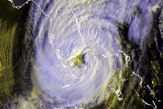
Source: NOAA. Hurricane Wilma makes landfall in Florida in October of 2005.
This is also a year where we'll keep our fingers crossed that some record streaks keep going. Even though we have seen destruction over the past several years - it could be much worse. Consider this: the United States has not seen a Major (Cat 3 or higher) hurricane make landfall since 2005. That's over 8 years and counting. No one alive has seen a period this long without a 'Major' hit.
According to Colorado State University meteorologist and hurricane expert Phil Klotzbach - "This is the longest period on record with no major hurricane landfalls since 1878, when reliable landfall records began."
When a storm strikes, the 24/7 media coverage may make it seem like we are constantly getting pummeled by more and more storms, but it is far from the truth. We've been fortunate to not take the brunt of the strongest storms the tropics can conjure up since Wilma hit at the tail end of the epic 2005 season (October).
 Doppler radar loop of Hurricane Wilma making landfall
Speaking of Wilma, can you believe Florida hasn't taken a hit from a hurricane in 8 years, either? And yes, it was Wilma. Not a single hurricane has come ashore in the state that has 1,260 miles of coastline, sticking out into the tropics. For historical reference, 114 hurricanes have hit Florida in ~160 years. During that time we've seen more growth, more towns go up, and more people move in to the Sunshine State. It's a recipe for complacency and danger, because we know that streak cannot continue much longer. The luck will run out.
Source: Roger Pielke
A Closer Look at New England:
Here at home? Well we have quite a long streak going here, too. We haven't had a hurricane make landfall in Massachusetts since Bob, nearly 23 years ago. It was another one of those 'sneaky seasons,' as Bob was the only hurricane to hit the U.S. in 1991. Hurricane Bob killed 18 people and caused more than $2 billion in damages.
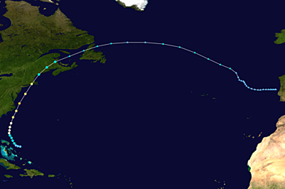
Hurricane Bob's track in August of 1991. Source: Accuweather
When it comes to the 'notorious' list, these are the storms anyone who's lived here for a long time remember clearly. MEMA has put together some information on these storms, and you can always find links on ways to prepare for hurricane season on their site as well. One of my personal pieces of advice - get a waterproof, fireproof, lock box and start filling it. Put important documents in it that you would be in a rough spot if you lost them (passport, deed to the house, titles for property, wedding certificate, insurance policies, birth certificates etc). Take an external hard drive or series of thumb drives and put photos that are precious to you on them, then place them inside. Having all these redundancies will come in handy if property is damaged, whether it be from a hurricane, tornado, or fire. It will make the process of getting back on your feet easier.

The worst of the worst is the Hurricane of 1938 - a storm that blasted northward and plowed into the New England coastline wreaking havoc and taking down an astounding 2 billion trees in the process! The destruction is nearly impossible to fathom. Blue Hill Observatory gusted to an incredible 186mph.
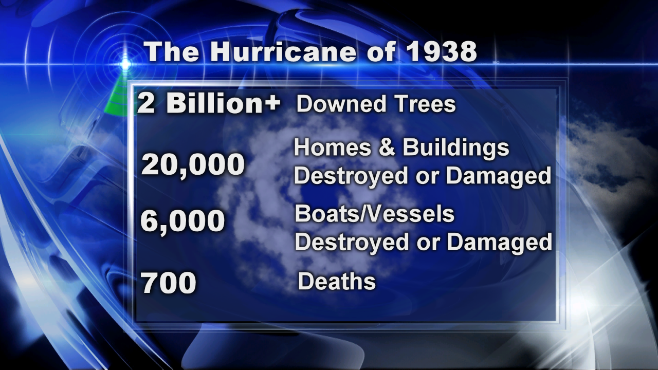
Which brings us to our 'worst case' scenario. In essence, it is the 1938 hurricane. It would be difficult to imagine something more devastating for the region. The population of MA/RI/CT was approximately a combined 6.7 million according to the 1940 U.S. census. Now it is 11.1 million, a growth of 4.4 million more people living in our area. Those people have accumulated more wealth, and more belongings. In short, there's just a lot more to destroy now than there was in 1938.
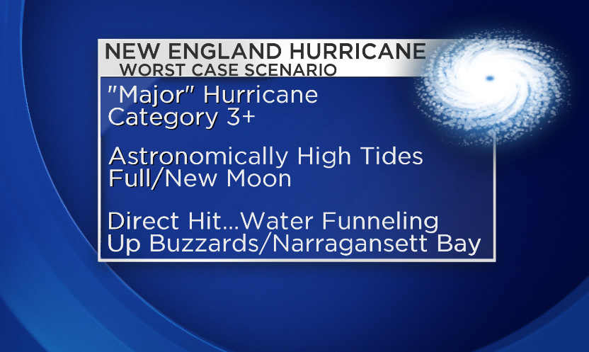
So a 'Major' hurricane, barreling up the coast, striking in conjunction with astronomically high tides, and taking a path slightly to the west of Buzzard's Bay, is estimated to be our 'worst case.' That path would bring destructive winds across all of the area, and would push storm surge into Buzzard's and Narragansett Bay. These bays are extremely dangerous spots when tropical storms make landfall, as they collect storm surge until there's no where else for the water to go but inland. That's what we saw in Raritan Bay outside of NYC during Sandy.
El Nino - In Play This Year?
Currently, NOAA is estimating a 65% chance of El Nino developing by late summer. It's not a slam dunk, as signs have wavered and most models have backed off their earlier predictions of a 'Super Nino' potential. But even a weak El Nino could play into the tropical forecast, should it develop by August or September.
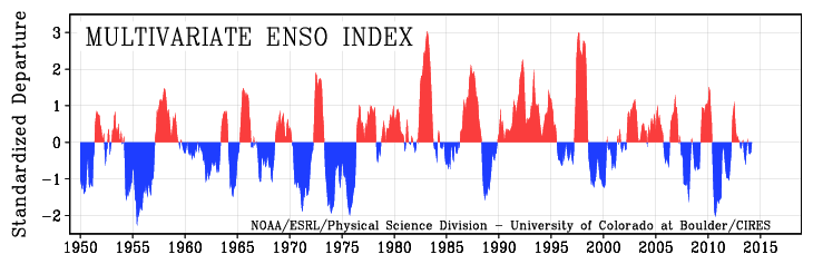
Source: NOAA Environmental System Research Laboratory
Why does it matter? El Nino El Niño is the warming of the waters of the East Equatorial South Pacific. It is the opposite of La Niña, which is the cooling of the waters in the East Equatorial South Pacific. We track these changes by looking at sea-surface temperature anomalies, which we can obtain by satellite and buoy data.
When El Nino, the warm phase of ENSO is occurring, wind shear increases over the tropical Atlantic. If you don't like tropical storms, wind shear is your friend. It blows the tops off developing thunderstorms and keeps them from congealing into a more cohesive tropical system. Upper-level lows can also increase wind shear over areas of the tropical Atlantic, which we saw quite a bit of last year.
El Nino isn't a 'cure' for hurricanes. They can, and do, still happen with a warm ENSO phase. There are many other variables at work, like SSTs, Saharan dust, MJO (Madden-Julian Oscillation) pulses tracking around the globe, etc. But it does lower the odds of an active season. It's something we'll be watching closely this summer.

Current SST anomalies. Source: WeatherBell