On The Hunt For May Warmth
Find Eric Fisher on Twitter and Facebook
I feel like spring is one of those seasons that we all remember as beautiful, but definitely carries with it plenty of speed bumps along the way in real-time. On Sunday I was sitting in a cafe with my wife, watching people desperately pretend that it was beautiful out. Now don't get me wrong, it was decent out, and definitely not unusual May weather. BUT...it was pretty funny to watch the grimaces on people's faces, sitting defiantly at their tables outside, hair flying in 30mph gusts, raindrops splatting down on the sidewalk. I can only imagine someone in southern California would get a good chuckle out of it. But that's what we do. New Englanders wear our weather as a badge of honor, and we will ourselves to head outside even when it's anything but perfect out! And progress is being made, even if we're not at the beach just yet.
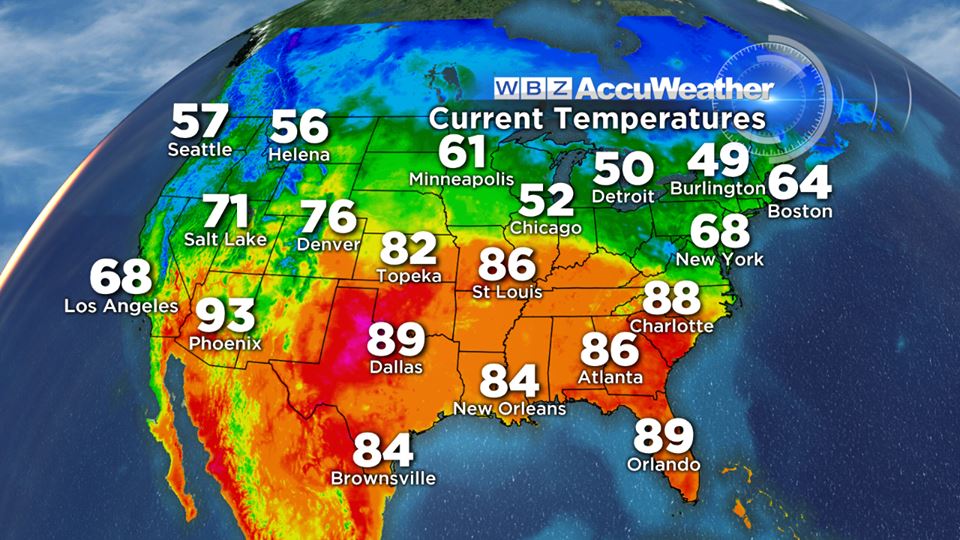
Monday afternoon temps across the country featured a lot of warmth to our south!
The rest of this week will feature a lot of staring to our southwest, where summer warmth will start nosing in our direction. Already there were widespread 80s and 90s across most of the southern tier on Monday, and there's plenty more where that came from. There will actually be 100s and extreme fire danger in the Plains where they're smashing heat records. Over the weekend, Wichita, KS hit 102º, which beat the previous record for first 100+ day by a MONTH! That is an absolute crushing. Oklahoma City just had its earliest back-to-back 95+ days on record between Sunday & Monday. While I'll admit to wanting some more warmth, I'm definitely not interested in any of that!
Our Tuesday will be very similar to what we saw on Monday. There's still a cold pool of air aloft, around -29ºC at 500mb, which helps to produce steep lapse rates and widespread cumulus clouds during the midday and afternoon hours. You'll find the most coverage of these clouds across southern NH and the hills of eastern MA, and there may be a spotty shower or two mixed in. A northwesterly breeze will stay in the 10-25mph range, and highs again should max out in the upper 50s to mid 60s. A fairly average and typical early May day for us.
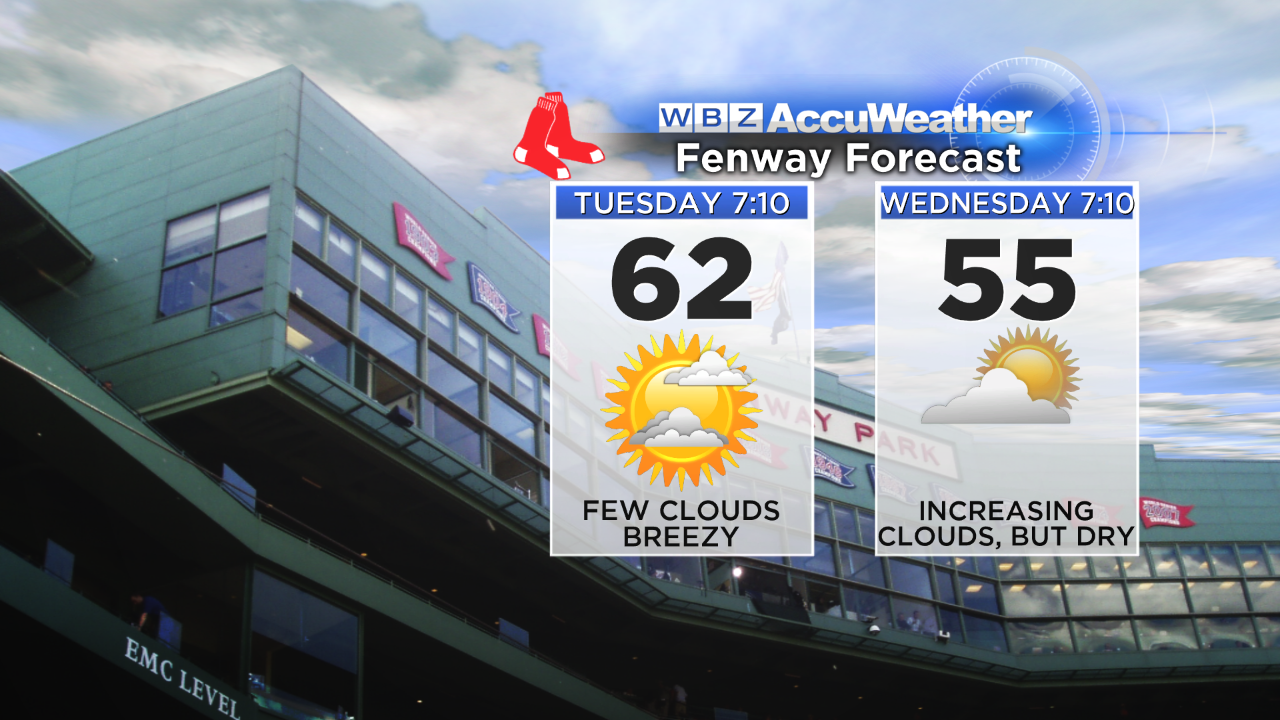
Wednesday is probably my pick of the week. Why you ask? Less wind. High pressure will be cresting overhead, which should help give us lighter breezes and plenty of sunshine. That sun will mix with areas of high cirrus clouds, with highs in the low 60s. The daytime heating should be enough to kick up a sea breeze, so coastal towns will see temperatures drop back down through the 50s.

Thursday and Friday will feature warm air oh-so-close. The warm front, acting as the leading edge of all those 70s and 80s, will be close to NYC. Southwest of that boundary they'll be in shorts. Northeast of it, cool air prevails. That front, along with high pressure over SE Canada, should draw in an onshore flow and keep highs generally in the 50s, with some 40s possible on Friday near the coast (particularly the NH Seacoast down to the South Shore).
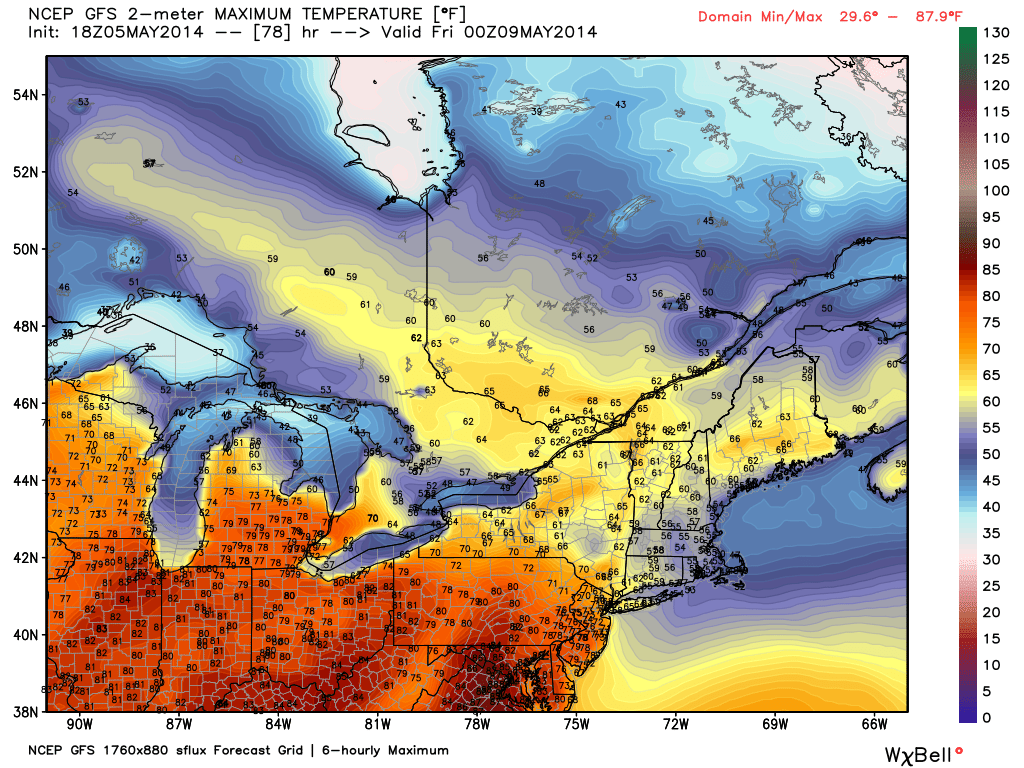
A look at GFS forecast highs for Thursday. You can see some pretty significant heat up to a NYC/Binghamton/Buffalo line, but likely no farther. Source: WeatherBell
Along this warm front there should also be a batch of showers sliding from NW to SE. Right now, it looks like Thursday will be mainly dry with a slight risk of showers. But that risk grows on Friday, and I think we should pick up at least *some* rain as the front gets closer. In any case, we should certainly end up with more clouds on Friday - a cool end to the week.
The weekend is (naturally) the biggest question mark in the forecast. Models are in pretty poor agreement on the way things will set up and unfold. A key question - will a warm front finally blast through and open the gates to warmth? Or will the setup just throw some clouds and areas of rain through the region, with just a window of drier weather and warmer temps? The solutions range from our first 80º day to just 50s/low 60s on Saturday and a wet start to the weekend.
So what to do? Don't cancel any plans. I'm pretty confident that we're going to need another day or two to start nailing down how Saturday/Sunday will pan out. On Monday night's broadcast I stayed optimistic and went with a mild solution, but it's not set in stone yet. We should definitely end up with some rain, and the atmosphere will be charged up with plenty of water vapor to help that happen. But at this point I don't think we're in for a washout. Stay tuned and we'll keep our fingers crossed for Mom.

