Spring Returns For The Holiday Weekend
Find Eric Fisher on Twitter and Facebook
Note - Thanks to all who have sent kind messages of encouragement as I get ready to join the masses in the Boston Marathon on Monday! The training is done, we made it through winter, and now it's go time. If you are feeling generous and would like to support my cause, here is the link: http://www.crowdrise.com/EricFisherWBZ/fundraiser/ericfisher4
The sun is a tricky thing in April. Even when it's cold, it's not THAT cold. Since skies were bright over the past couple of days, there wasn't too much grumbling on the streets. But have no doubt, this is some pretty unusual stuff for this time of the year. The high of 40º in Boston was just 1 degree away from a record low max for the date, which was set 134 years ago. So in essence, Thursday was one of the coldest April 17ths in generations, and was at the very least very unusual. We've been just a few degrees away from record lows at night as well. And this is why we don't plant gardens in April here in New England! Too much risk for cold nights still. Although it breaks my heart - have seen so many annuals out at some stores. A lot of them at night, meaning no one brought them in. Guessing another call to the greenhouse will be in order.
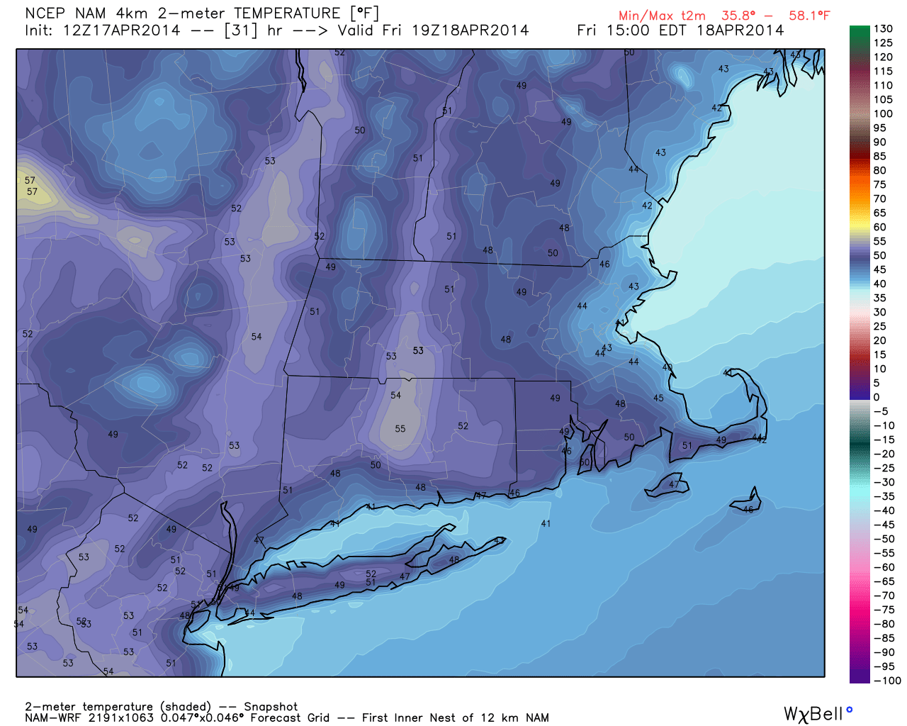
WRF temperatures look about right to me for daytime highs Friday. Can easily spot the onshore flow influence, but a little easier to take Worcester Co. and the CT Valley. Source: WeatherBell
One last cold day to go, and then we're on the mend folks. Our onshore flow off the chilly Atlantic will continue today, but the setup is just a little different than what we saw yesterday. The consistent flow over water has helped increase moisture in the atmospheric column, particularly the lower levels. Plus, air is warming aloft. So you have a layer of moist, cool air with warm air above it, which we call an inversion. That inversion should trap this moisture today and keep quite a bit of low cloudiness around far eastern MA and across all of the coast. It's marginal, but going with a gray forecast for the majority of the day. Whether the clouds break up or not, the onshore flow will again keep highs here in the low 40s. Farther west into Worcester County and beyond, the skies should end up brighter and temperatures should manage the mid 40s as a result. With a little more sun, some 50s are possible toward the Quabbin and farther west into the Connecticut River Valley.
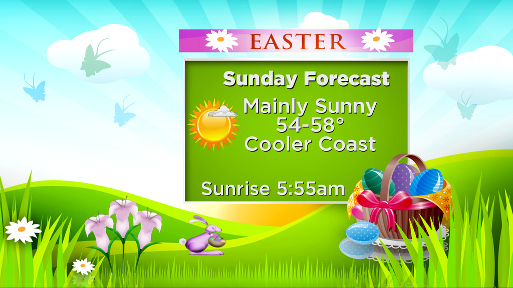
EASTER WEEKEND
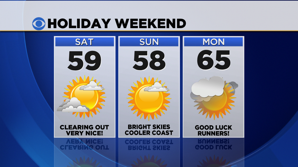
Friday night we'll turn our attention to an approaching cold front from the west. Not much energy with this one, but it's going to lend us a serious helping hand. The push from the NW will help keep an ocean storm at bay to our south in the Atlantic, and once it passes through will give us a dry WNW wind. The Saturday forecast has looked better and better as we've gotten closer this week, and it should end up with highs in the upper 50s to near 60! Great stuff, especially after this chilly stretch. The WNW wind should keep sea breezes away. The Sox are back in town, and it should be a great day in the grandstands.
High pressure settles over the top of us on Sunday, providing sinking area and loads of sun and mid/upper 50s. With a weaker pressure gradient, sea breezes will develop and keep the coast closer to the low 50s, falling into the 40s during the afternoon. Regardless, Easter egg hunts and Sunday sunrise services should all be in good shape without any disruptive weather to be found.
MARATHON MONDAY
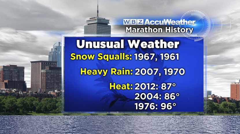
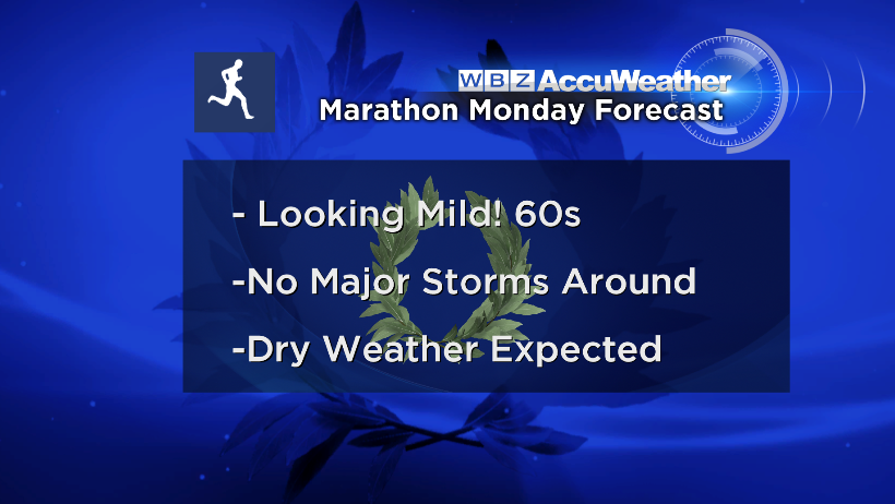
Day 3 of our holiday weekend - Patriot's Day! Still a few days out but I'm optimistic that we're going to have great weather for the 118th Boston Marathon. The day should start in the upper 30s around Hopkinton, warming quickly through the 40s and into the 50s by midday. Really excellent running conditions! The last wave or 2 may find it a bit *too* mild, with 60s expected in the afternoon at this point. Certainly not the sweltering 80s that caused so many problems 2 years ago, but warmer than most of the training runs we all endured this winter! A mix of sun and clouds should dot the sky, but we'll keep a wary eye on a warm front across northern New England which is close enough to at least monitor. For now, all day. Good luck to all my fellow runners!
GRAPHIC OF THE DAY
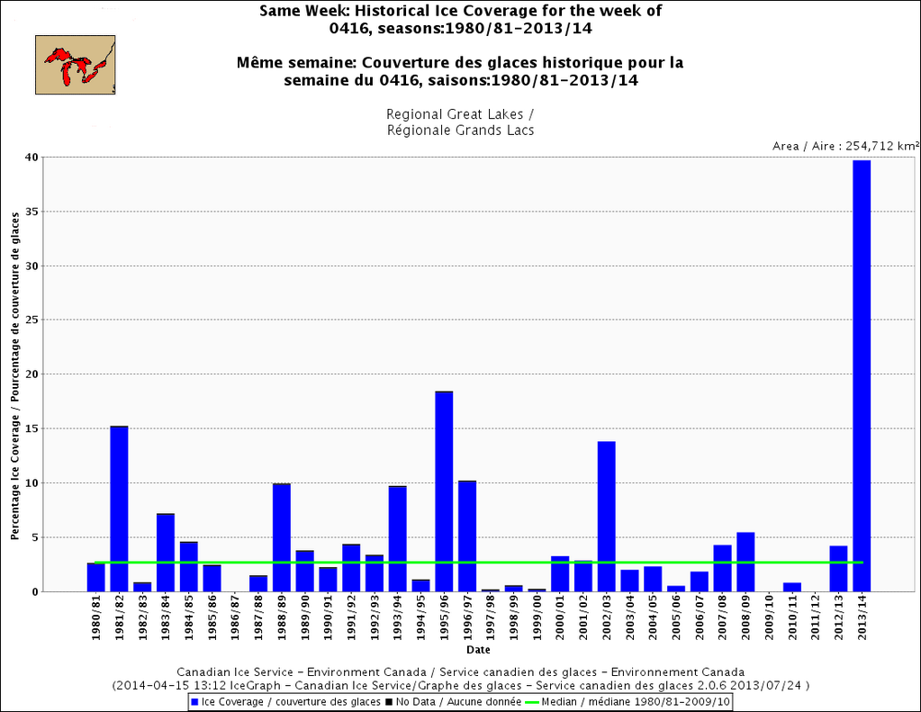
We all know it was cold this winter, but it is still leaving a dramatic mark. Take a look at the ice cover on the Great Lakes, STILL, at this point. The coverage absolutely obliterates all prior years on record. Granted the period of record is very small for this statistic, but we can say with overwhelming certainty that there hasn't been anywhere even close to this much ice on the lakes in mid-April for decades. A big portion of that ice coverage is due to Lake Superior, which is still 64% covered.