Closing The Books On A Record Cold March
Find Eric Fisher on Twitter and Facebook
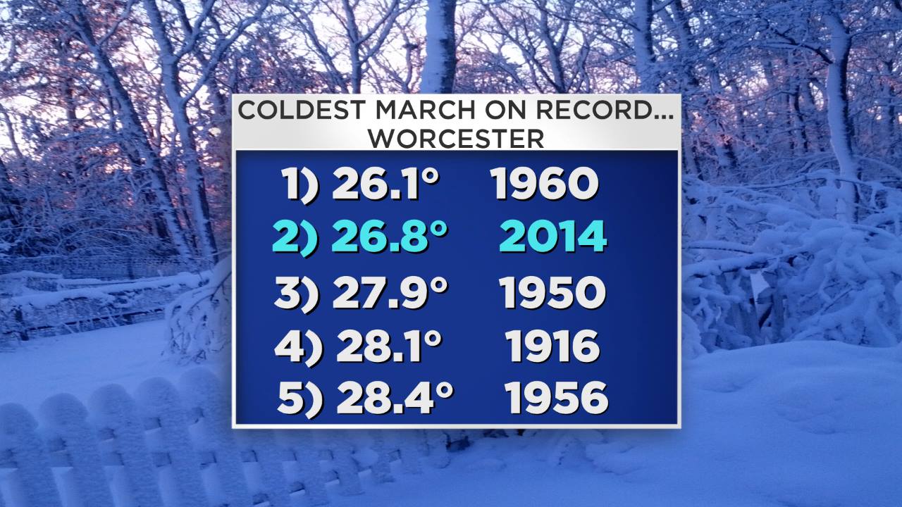
I think we all can agree that the majority of this March was pretty uncomfortable. Through Friday, Worcester is sitting at its 3rd coldest March ever recorded (average temp of 26.8º), and Boston may finish in the Top 10. But while we're *close* to the records around here, the numbers farther to the north are truly eye-popping.
I'm going to use Burlington, VT as a case study for this one.
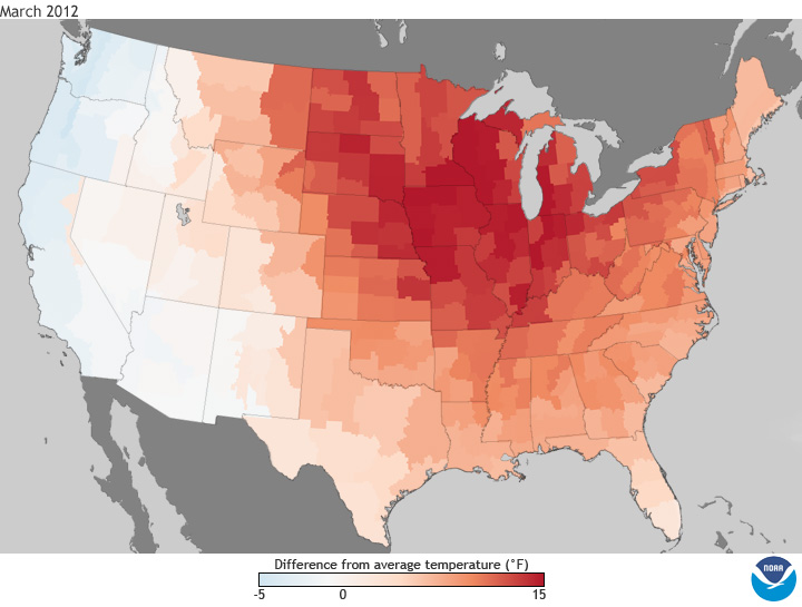
Remember back to March 2012. The maple syrup season was a bust as temperatures soared into the 80s. Blooms came out far too early, spoiling some fruit tree crops when a cold blast returned. And we basked in record highs almost daily. The average temperature for that month in Burlington (the average of all hours, day and night, through the month), was 43.2)º. That was easily good enough for the warmest March ever recorded.
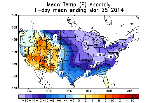
Flash forward to this year. Through the 27th, Burlington is running at 20.1º for an average temp – a whopping 23º colder! In the world of weather and numbers, that is absurd. But consider this: That average temp in March of 2012 is approximately the same as the highest temperature recorded all month long this year! On March 11th and March 15th, the high temp peaked at 44º. That's it. As warm as it has gotten at any point, all month long, and it shouldn't reach 40º again before the month ends. In contrast, March 2012 climbed above 44º 21 separate days. Forget 44º…it topped 60º nine times. You get the picture. And Burlington is not alone – Caribou, ME is also currently on pace for its coldest March ever recorded. The average temperature there so far? A mere 13º.
So in short, Burlington may be able to nab the distinction of having their hottest and coldest March on record within 2 years of each other. That depends on how far north the warmth can get this weekend. The figure to beat is an average monthly temp of 20.7º, set in 1916. Records there date to 1884, so it's absolutely wild the city could accomplish this in the face of 130 years of record keeping. Even if this March ends up #2, it's quite a feat.
You couldn't find a more completely opposite setup in the atmosphere between these two years. In this current situation, a massive ridge parked over the West Coast and northward toward Alaska (+PNA) has kept the freezer door open, with arctic air consistently pouring southward into the Midwest and Northeast.
In 2012, that huge ridge was right over the central U.S. and didn't have any inclination to move. Most of the country jumped right into summer and records were beyond smashed. We may never see another March that warm again in our lifetimes.
Source: NOAA and Climate Prediction Center
Just off to the south, Mt. Mansfield still has over 80" of snow at the peak. That's high enough to bury me standing up and wearing boots. Not a completely unusual amount of snow for this time of the year, but the question is – how much more will they get this weekend and how long will it stick around for? With no major warm-ups ahead and the possibility of a foot of fresh snow at the summit this weekend…that snow cap may live for many weeks yet.
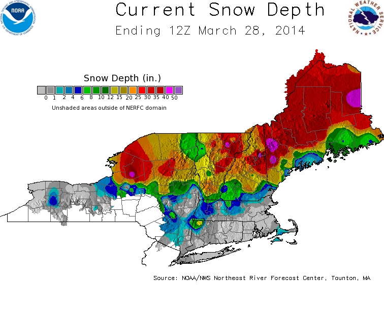
Many areas of northern New England still feature well over a foot of snow. There are areas of interior Maine that have over 4' of snow on the ground, with another foot on the way this weekend! It's going to be very difficult for anyone to finish hiking the Appalachian Trail anytime before June at this rate. There still aren't any signs of rapid warming heading into/through April, so this should end up being a slow and orderly melt. That's not great news for people staring out at a vast frozen tundra, but it's definitely good news for people downstream. No one wants to melt 3-5' of snow in a hurry.
Great Lakes - Still An Icy Landscape:
Source: GRERL
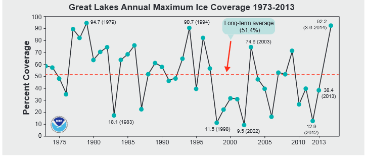
And if you glance to the west, the Great Lakes are still more ice than open water. You heard a lot of chatter about the extent of ice coverage earlier in the month, which peaked at 92.2% and claimed the 2nd most extensive coverage on record, plus the most for so late in a season. Well even though a good portion of that ice has melted away, the current picture is dramatic.
The March 28th update from the Great Lakes Environmental Research Laboratory (GRERL) placed ice coverage at 71.1%. That's a staggering figure. The 40-year average for PEAK ice cover in a given cold season is 51%. Which means that even know, as we're about to turn the page to April, there's vastly more ice than you'd typically expect in the depths of winter during an average season.
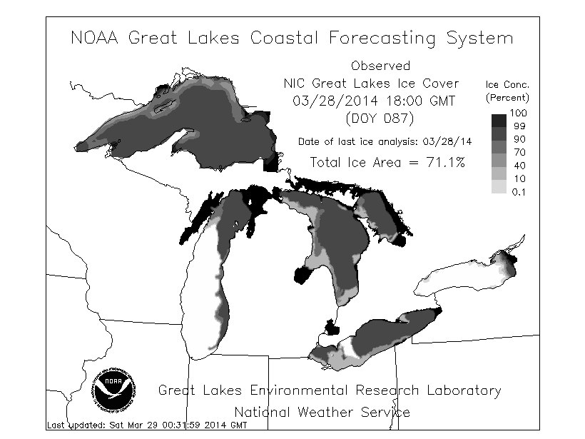
Source: GRERL