Close Call With A Powerful Storm
Find Eric Fisher on Twitter and Facebook
Source: NOAA
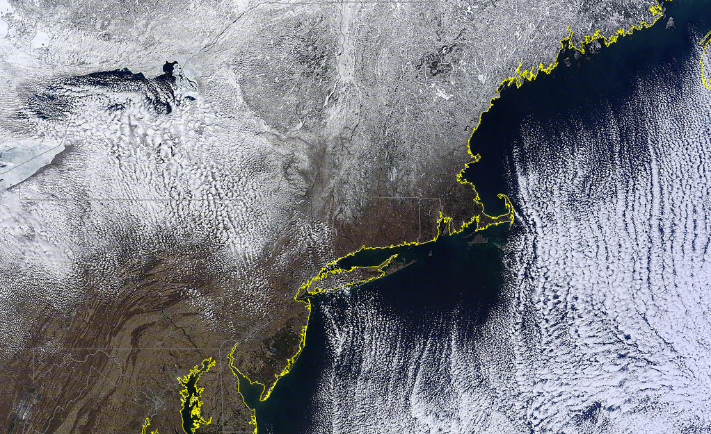
Setting the stage with more cold weather. Highs today stayed in the 20s for many towns, near records for the date but not quite cold enough to tie them. The average high in Boston is nearly 50º this time of year, so today's weather was far from the norm. The clear skies did reveal a striking image from space though! A MODIS pass showed beautiful cloud streets over the ocean (cold air plowing over the milder ocean water), and you can clearly pick out the ice/snow on top of big water bodies such as the Quabbin Reservoir, Lake Winnipesaukee, and Sebago Lake. Those covered lakes are a sign of the cold and snowy winter we have endured, which is not done yet!
Timing:
This storm will pose no issues for us through tonight and most of tomorrow, so no worries at all for your plans there. Clear skies will give us temps in the 5-15º range for most towns tonight, and we'll rebound into the low/mid 30s tomorrow as sunshine gives way to increasing clouds, and a snow sky by evening. There's a chance some stray areas of light snow may break out late afternoon and during the evening around the South Coast, but this activity won't be part of the 'real deal' and shouldn't create any issues.
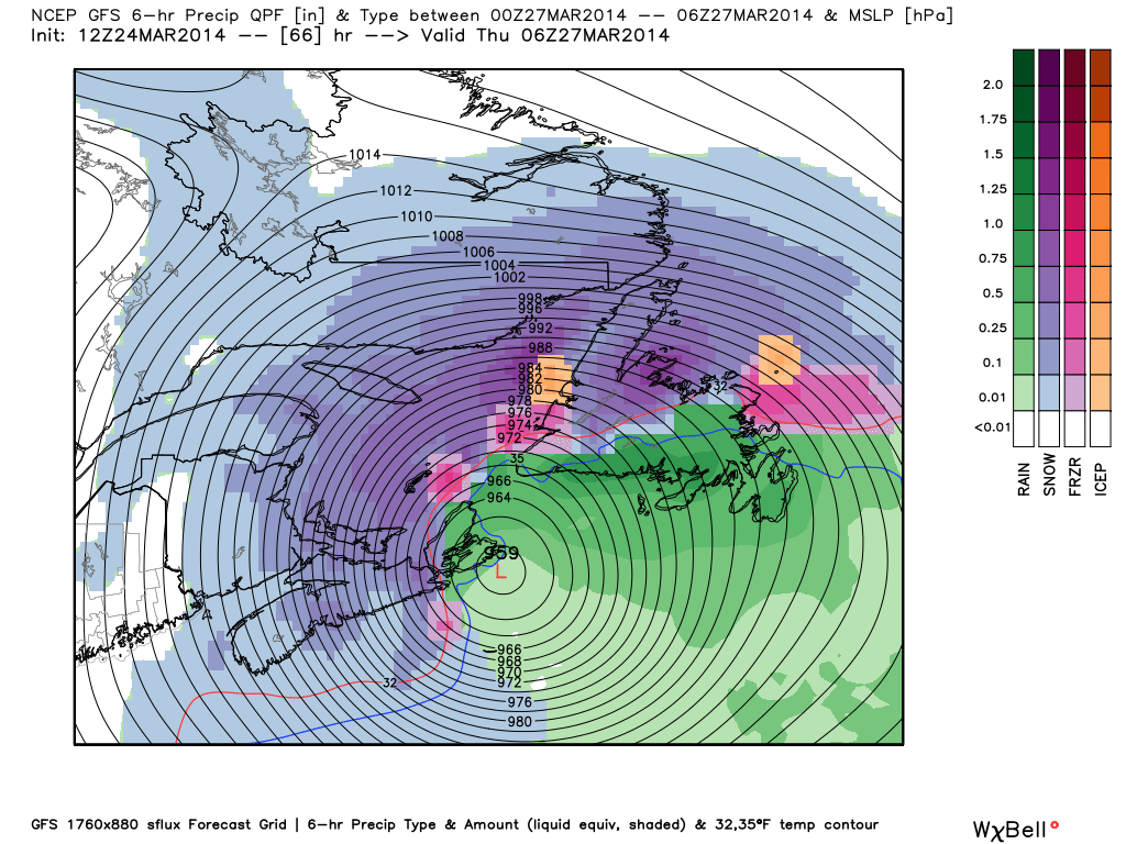
The nor'easter itself is essentially nothing right now, if you went looking for it on radar or satellite. It will be born from two pieces of energy, one from the southern stream of the jet which is creating unsettled weather around the Gulf Coast this evening, and northern stream energy which is bringing some scattered snow showers around the Great Lakes. These two areas will converge and produce an extremely rapidly developing low during the day tomorrow and into Wednesday.
Snow should start to break out overnight, mainly after 9pm, and will start to get heavier after midnight for the Cape and Islands. By late in the overnight and into Wednesday morning, we will hit the peak coverage of snow across the area. So by and large the most difficult travel conditions will be Wednesday morning. By midday the snow will be reduced to some ocean-effect activity, and will be all finished by the evening as the storm departs.
Bombogenesis - Why and what does it mean?
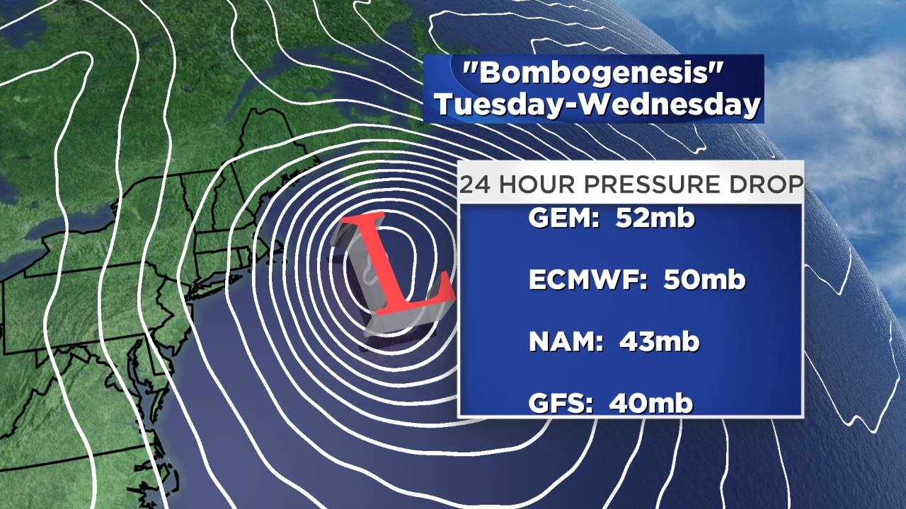
GEM = Canadian model, ECMWF = European Model, NAM = North American Model, GFS = Global Forecast System Model
You hear this one every year during the winter, and this one has been no exception. 'Bombogenesis' is when a low pressure center drops more than 24mb in 24 hours. You may also hear this called a 'Meteorological Bomb' or 'Coastal Bomb.' Several storms this year have done this right near our coast. What makes this one different is the depth and speed of this pressure change. Below I've listed a suite of different models, and what they project for this storm. In general, it's likely it will drop between 40 and 50mb in 24 hours...bombogenesis twice over! An innocuous 1008mb low off the southeast coast will become a monstrous storm SE of the benchmark (40N, 70W). We're thanking our lucky stars that it's expected to move outside the benchmark, because if not we would surely be talking about a storm of historic proportions across the region.
So what does this bombogenesis actually mean for you? Well, it means that this is a storm not to be trifled with. While I'm confident in our forecast, a change in 50-75 miles would make for a TREMENDOUS difference in outcome. And it's not a 'some snow, no snow' difference, because of this one's power. It's the difference between very heavy snow and destructive hurricane force winds, and a gusty storm with a little snow. Lows that deepen to this point have such excellent snow growth and heavy snow bands that if one meanders a little east or west, you change the outcome dramatically.
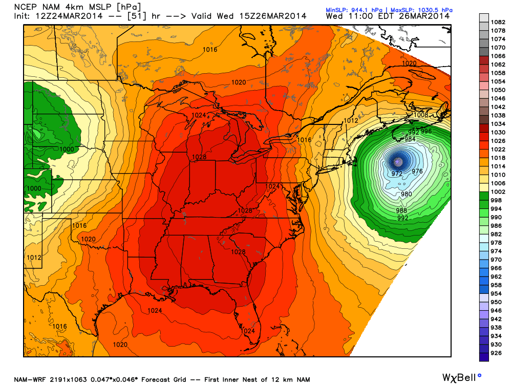
4 km WRF model shows forecast for the storm. Pressure this low is rarely seen in extratropical cyclones. It should get down to the lowest pressure in our part of the world since Hurricane Sandy. With a storm deepening like this, I would bet that an 'eye' feature will form, viewable by satellite, on Wednesday. Source: WeatherBell
So the bottom line is that you should always follow forecast *updates*. I promise, this isn't some crazy guise to garner ratings and make you watch more. It's out of legitimate concern about the impact of the event. Weather is not giving out facts, it's giving opinions and following changes in our atmosphere. It's perfectly natural for things to change over time. While my thoughts on this storm have barely budged an inch since last Friday, that's not saying there isn't some chance, however slight as it may be, that it could change in the next 24 hours. So stay prepared, not scared!
Wind - Of as Much Concern as Any Snow Totals.
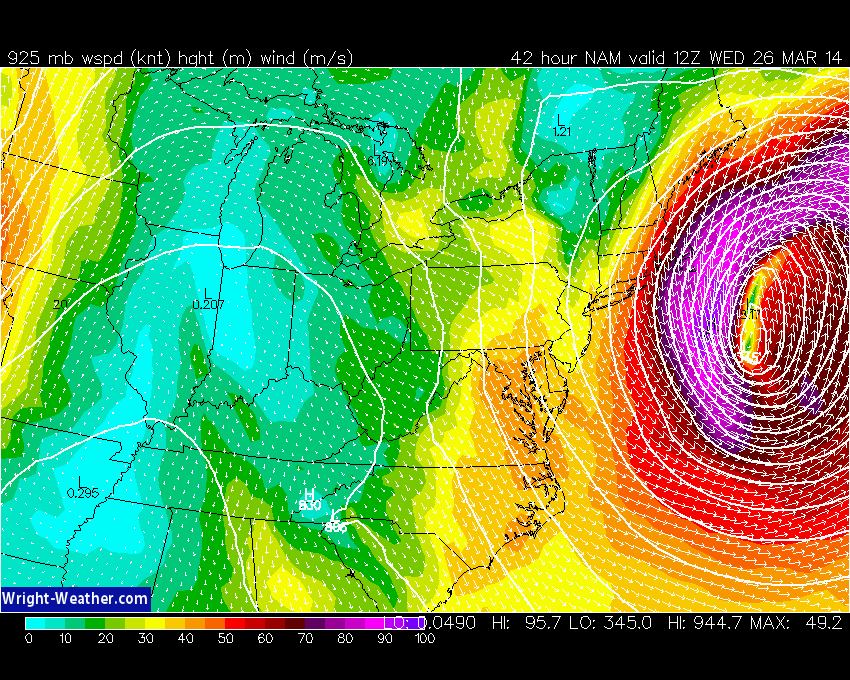
NAM forecast 950mb winds, not far up above the surface. This particular run at 18z Monday shows 100mph winds over the Outer Cape and Nantucket. This may translate to some hurricane-force gusts at ground level! The NAM and ECMWF are showing this potential more so than the GFS, which is farther out to sea with the low center. And many models have SUSTAINED hurricane-force winds over the open water. Not a good time to be out on a boat around Georges Bank.
Usually a lot of the focus for a snowstorm goes into, you guessed it, snow totals. But in this case, especially with the absence of widespread significant totals, I'd urge everyone to pay careful attention to the wind component of this one. With a low expected in the 960s or 950s (millibars) to our east on Wednesday morning, and a high around 1030mb to our west, we're talking about HUGE pressure gradient. Pressure gradients are changes in pressure over distance, and the greater they are the stronger winds typically are. A deep nor'easter like this one should wrap around the strongest winds we've seen from a storm all season. When we talk about winds gusting over 60mph, we're talking about destructive winds that could bring down trees and power lines and help produce whiteout/blizzard conditions. The area that may see these wind speeds realized is small, but if you live there you don't care about how small the area is! It impacts you and your preparation for the storm.
The breakdown on winds is that they will decrease dramatically as you move west. I don't expect any issues except gusty weather for central and western MA/southern New Hampshire. But on the North Shore and South Shore, as well as downtown Boston, we could see gusts in the 30-50mph range. Across Cape Cod and the Islands, gusts may be in the 40-65mph range. And we can't rule out some gusts topping 70mph if the storm track comes just a tad farther west. The strongest overall would be over the Outer Cape and Nantucket. I'd plan on the potential for outages, to be on the safe side.
It's always good to plan on a 'worst case scenario' for the same reason as you'd like your doctor to give all the possible side effects before a surgery. Don't you want to know what the worst possible thing that could happen is, so you can prepare for it? Weather works in the same manner. You can never be over-prepared for something. So even if there's a LOW probability of hurricane force winds (which is there), wouldn't you want to know that it's in the realm of possibility and therefore plan for it accordingly?
Snow Totals - Big Differences Across a Small Area
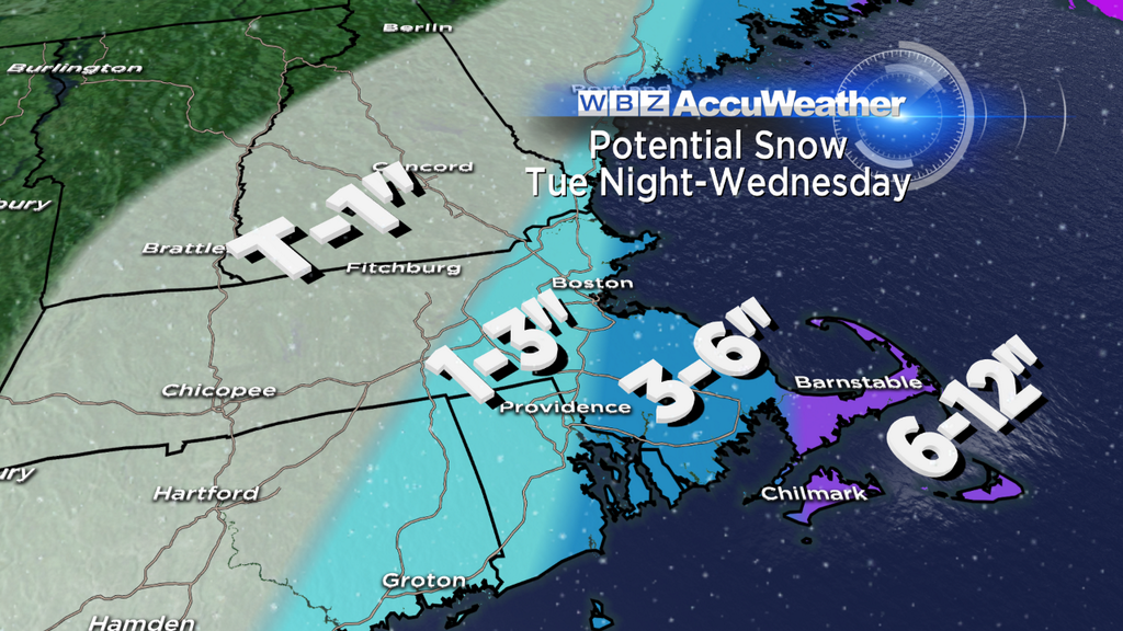
Strong, tightly wound storms like these often have sharp back edges to their precip shields, and we expect the same with this one. So snow totals should drop off very quickly from east to west (adding to some forecast headaches!). The general idea, as it has been, is for the highest totals to be located on the Outer Cape & Nantucket, falling off as you head toward Boston, and very little at all from Worcester westbound. There's an outside shot at more than a foot for the Outer Cape & Nantucket, should the storm come in just a small bit farther west. Near the coast from Cape Ann down to the South Shore, we'll have to keep an eye out for any ocean-effect on Wednesday which may bolster a few totals. But overall I think this gives a good idea. Again - check back tomorrow to see if any changes are necessary! By looking at this you can imagine what would happen if things move 50 miles either way.
Coastal Flooding - Watching Wednesday Morning High Tide
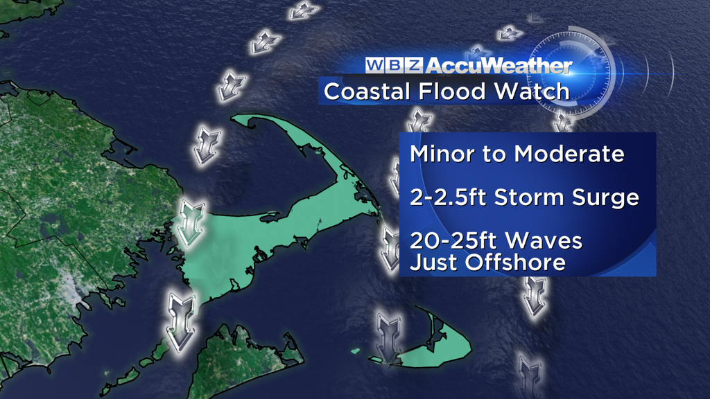
The only timing for coastal flooding issues looks to be Wednesday morning's high tide, which is on either side of 8am. Beaches and communities that are north-facing are most at risk, as very strong northerly winds push water up against the shore with a 2-2.5' storm surge. Fortunately, this storm is progressive and fairly far out-to-sea, otherwise this could be a lot worse. But keep a close eye to the tides during the Wed am time frame.
Blizzard - What Is It?
This comes up all the time, every winter. What exactly is a blizzard? I feel most have a 'picture' in their mind about what one is, rather than the official definition. That definition is for at least 3 straight hours of falling/blowing snow creating visibility <1/4 mile, and winds sustained or frequently gusting over 35mph. See something missing? SNOW. How much snow you get has NOTHING to do with a blizzard. In fact, there are many blizzards across the Plains of this country that involve no falling snow at all. So keep that in mind when you hear about blizzard conditions.
If upgraded to a Blizzard Warning, this will be the FOURTH time we've had Blizzard Warnings posted in the jurisdiction of the Taunton NWS this winter. Pretty wild stuff. However, only one of the three so far has verified (the storm after New Year's Day). The other two fell a bit short. So long as this storm doesn't track farther out to sea than expected, it's a great candidate to verify during Wednesday morning. It will have the strongest winds of any of the storms we've seen so far, and thus wind + snow = low visibility. Bottom line is that travel will be very treacherous across far SE Mass late Tuesday night and into Wednesday morning.
What happens after the storm leaves us? El crusho for the Canadian Maritimes. This powerhouse storm will bring widespread snow and wind to a region which isn't all that unaccustomed to big storms. The storm will have filled in and occluded by this point, but will still pack quite a wallop.
Sick of all the madness? Well you, sir or madam, are in luck. Once we get past this there is a whole lot of milder air waiting in the wings. Some ridging should form over the Northeast, and we have many days at or above 50º in our forecast Friday through the start of next week. In fact, we may even top 60 a couple of those days. So snow will not be sticking around, and perhaps we have finally turned the corner and can start thinking spring.