Too Close For Comfort
After yesterday's 52-62 degrees, it was colder today with highs in the lower to middle 40s and tomorrow will be even colder thanks to the passage of another cold front today. The cloudiness is exiting so tonight will turn out mainly clear with a decreasing wind. It will chill off to the lower to middle teens with a few outlying lowland locations falling into the upper single numbers. With sunshine yielding to some patches of small puffy clouds tomorrow, it will only warm up to 28-32 degrees and that is about 20 degrees below the average.
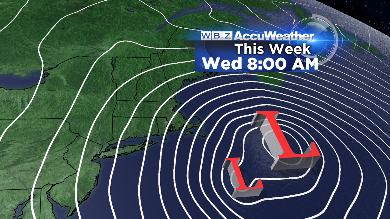 As this is happening, an upper level disturbance is streaming across the northern Rockies into the northern Plains. This impulse will be a key player in the upcoming evolving complex ocean storm scenario. The trough of low pressure will spread some flurries across the Midwest tomorrow and as it magnifies into the eastern portion of the nation, it will tap a supply of moisture along the Gulf Coast. Eventually, a storm will begin to form in the southern stream off the northeast Florida coast and another one will blossom northeast of the North Carolina coast in the northern stream. These two separate centers will both intensify and interact with each other in some way, shape or form. It appears that the greatest upper level support favors the southern stream storm which will be the most distant storm offshore as it is starting to track northward as a closing upper level low pressure system develops. The northern stream system may loop around to the southwest of the southern stream system as explosive deepening transpires. The northern stream system will likely be absorbed by the southern stream storm and that one will become a superbomb with the central pressure dropping under 950 millibars or about 28.0". This is just a bit higher than Superstorm Sandy which had the lowest barometric pressure on record of any land-falling Atlantic storm north of Cape Hatteras! This kickback or looping might be a big threat under blocking conditions but, fortunately, as has been the case all winter, there is no downstream blocking so this progressive mode should escort this mega-storm out to the northeast quickly and that gives me some comfort. Nevertheless, a storm of this magnitude which is close to the region is high stakes and it makes us forecasters a bit nervous. We remain vigilant for possible forecast revisions.
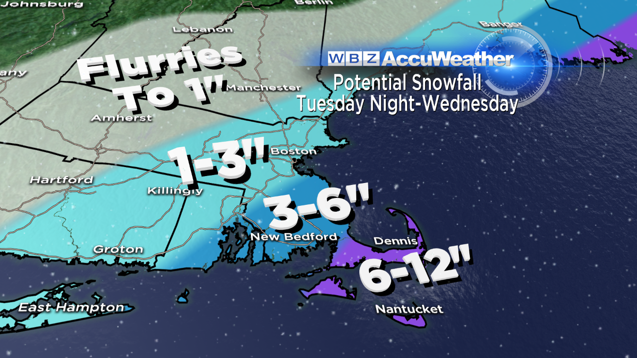 I feel that the fury of this storm will be spent over the ocean and on the Canadian Maritimes from Nova Scotia outbound. Cape Cod will be most vulnerable to the highest winds and snowfall totals. While it cannot be ruled out that much of the snow shield just misses the region, the more reasonable and responsible forecast at this time is to predict a potential of 6-12" over Cape Cod with 3-6" over the rest of southeastern MA ranging down to 1-3" in the Boston area north and west with an inch or less down to a dusting or flurries northwest of Worcester. Since this storm will not form until early Tuesday, we cannot be 100% confident of this prediction just yet. Any slight changes in the timing, placement and intensification of these storms may deliver a different solution as we get much closer to the event. Keep apprised of latest forecasts on WBZ News and follow the WBZ Weather Team on Twitter and on FaceBook for frequent updates.
After the storm, plan on high pressure building in for some sunshine and a brisk breeze on Thursday with highs in the upper 30s. As the zone of high pressure builds to the south of the region, a brisk south-southwesterly wind will propel much warmer air into the Northeast on Friday. Expect highs in the upper 50s. A frontal boundary will release some showery rains Friday night into early Saturday. If it clears out before noon on Saturday, it could warm well into the 60s that afternoon with cooler air in the range of 45-50 via sunshine next Sunday.
Next Saturday, the WBZ Weather Team presents a 1/2 hour special. it's called: "Eye On Weather: Spring Preview". We'll have several interesting topics including the spring forecast, severe weather, gardening and eating. Join us at 7pm next Saturday, March 29.
Todd Gutner posts his thoughts tomorrow morning and Eric Fisher follows later in the day.
Make it a great week!