All Uphill From Here (For A While)
Find Eric Fisher on Twitter and Facebook
Oh the fun sights of a winter that loves us so much it is never going to leave. If you're not a snow-in-March lover, at least you can take solace in the fact that we missed out on a St. Patrick's Day snowstorm. As we talked about last week, this storm stayed suppressed off to our south due to a big area of cold, dry high pressure anchored over the region. Didn't help folks down in D.C. though. With over a half foot of snow, it was the 3rd biggest snowstorm for so late in a season. So this photo of a snow-covered White House lawn is a pretty rare one indeed! Just two years ago, the cherry blossoms were already starting to bloom during a record-crushing torch of a month where highs routinely ran up into the 70s and 80s. Anything goes in March.
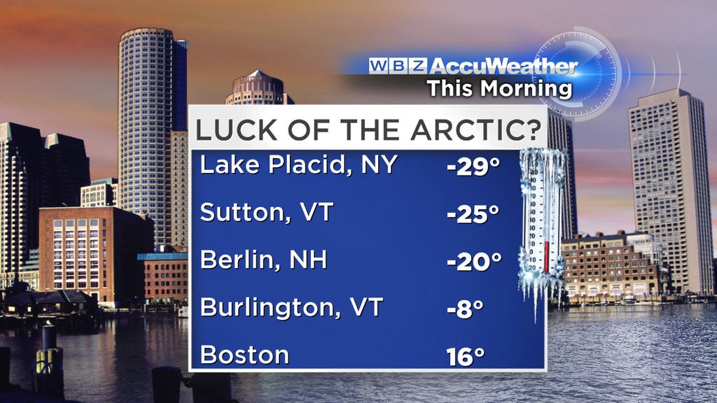
Daytime highs were close to all-time record 'low maximums' - meaning record for coldest high temperatures in this date. The record in Boston was 22º, and we hit 27º. For tonight it will be frigid again, but nowhere near the records. Our cities don't typically go that low under 'radiational cooling' nights due to the Urban Heat Island effect. Boston rarely lets go of its heat after a sunny day, and Worcester doesn't radiate much either. So the record of 5º in Boston and 0º in Worcester both look safe to me. However, the more sheltered valleys and cool spots should get down to the single digits, perhaps near 0º tonight. Not as cold as last night, which produced the coldest St. Patrick's Day ever recorded in Burlington, VT! That dates back more than 125 years. Makes the 16º in Boston look balmy.
Tomorrow we'll manage to do a bit better, with milder air aloft and lots of sunshine. Most towns will be up into the 30s. Not exactly tropical, but will feel good compared to today. Even better with the strong sun and pretty light winds as high pressure shifts just off to our east. The coldest areas should be near the coast, with an onshore flow and ocean temperatures at rock bottom for the year (in the 30s near the MA shore). Some cloudiness will mix in across far SE Mass with that same onshore flow, but no snow showers expected.
After another cold night, we'll continue the uphill trek to milder times on Wednesday. Most towns will reach the upper 30s to low 40s as sun gives way to late day clouds. The next storm system we're eying will track well to our NW and occlude, so all we get around here is a batch of rain/snow showers on Wednesday night. This could bring a round of 1-3" snow across parts of NH/VT/ME, but currently not expecting much more than some mix or a coating up to an inch here locally. The best shot for snow would be in the Route 2 corridor and across the border into southern New Hampshire.
Most of that activity should be done by pretty early on Thursday morning, and fortunately for us the winds will turn west-southwest. That's not a cold air flow for us...in fact that's how we warm up best! So right on time for the first day of spring, we'll have our warmest day of the week. The Vernal Equinox takes place at 12:57pm, and we'll celebrate with many towns reaching the 50s. The warmest areas will be across eastern MA, and there will be much rejoicing. No major complaints on Friday either, with widespread 40s. Again it's nothing spectacular, but is needed relief from the persistent cold. Especially when....
We look toward the weekend, and not enjoying what is lurking there. A clipper system is expected to arrive on Saturday, and there may be enough cold air around to produce a round of snow in New England. Of course it being 5 days out, the details on that exact track are still up for interpretation. The highest risk area would definitely be northern New England, adding to their very impressive snow pack. But I wouldn't rule out a track that would head closer to the Long Island Sound, and bring the snow line a little farther south. So stay tuned for this one...in any case we should see at least some rain on Saturday.
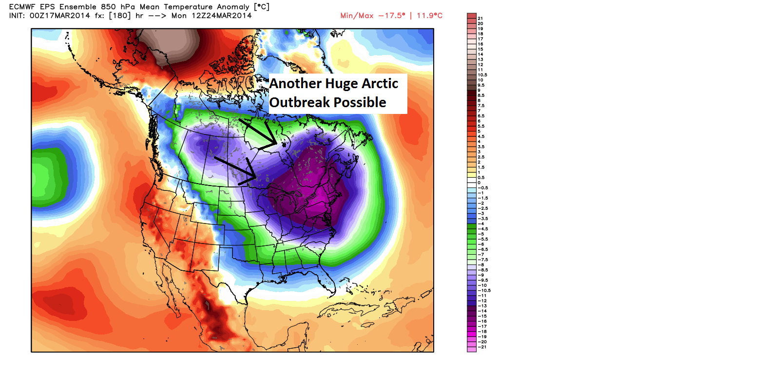
Behind that clipper is yet another blast of mind-numbingly cold, straight from the gates of the Arctic air. This one looks just as impressive as the blast we're dealing with right now, and there's the potential for it to be even colder. Models have been oscillating between 850 temps in the -15 to -21C range, which is fairly ridiculous for the end of March. I'm confident that it'll be much colder than average, the question is just how cold will it actually get? So get yourself mentally prepared for what looks to be another incredibly cold week to bring is into the final days of March. Undoubtedly, it will go down as our 5th straight below-average month for temperatures, a feat that does not happen very often anymore!