Quiet Week Ahead
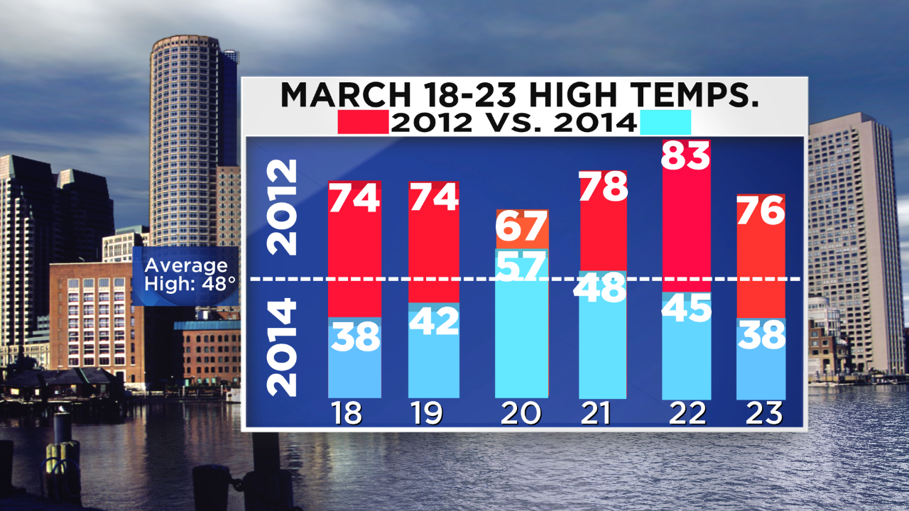 It has been another crazy week of winter here in New England. The northern mountains received the biggest snowstorm of the winter and the regional temperatures were on another roller coaster ride. From Boston's 60 degrees on Tuesday to wind chills near zero on Thursday and back to 57 today, I hope you're seat belt was fastened. It's right back to bad habits again tomorrow with highs closer to 32 followed by near 30 on Monday. That has been the theme of the winter- mostly colder than average with a few cameo appearances of warm days. It has been a much more typical old-fashioned New England winter compared to recent years especially the very bizarre 2012. On March 18-23, 2012, the respective high temperatures were 74, 74, 67, 78, 83 and 76 with three of those as new record highs! Study the contrast with my predicted highs for the same days this March. The respective projected highs are 38, 42, 57, 48, 45 and 38. Perhaps you enjoyed the first set of numbers much more but the reality is that it is just not typical. Studying all of the various global factors in play right now, analog years show strong support for a colder than average April with a flip to a warmer May. Consequently, be patient a bit longer because you and I know that it is inevitable that nicer, warmer days will eventually get here.
 The week ahead does not have any surprises for us according to present indications. The risk of any storms seems quite low. One will deliver a few inches of snow in the Washington-Baltimore area tomorrow night but that storm should pass out to sea south of New England. We will see the northern fringe of its high cloud shield Monday morning and there is a slight chance that a few flakes could briefly fall near the South Coast but probably most of them will skim over Long Island and perhaps graze Nantucket and Martha's Vineyard. After that, a frontal boundary will likely create a spell of showers Wednesday evening followed by a wave of low pressure releasing more showers on the region next Saturday. It is too early to be highly confident but it appears that the northern mountains could receive several inches of snow from that one.
With the bonanza of snow this week, conditions are absolutely dynamite for nordic and alpine skiing plus snowmobiling and snowshoeing across much of the area from northern MA and especially much farther north where up to 15-30" of fresh white gold mounted up. You can find packed powder conditions with, finally, lots of snow in the all of the glades and shoots. Please go take advantage of this paradise. It will be much colder on the trails tomorrow as two cold fronts will have passed through. More snow showers may release some powder at select favorable upslope locations tonight so you might find some untracked powder runs and that would be so sweet. Please be courteous and in control on the trails. Have a safe time.
Danielle Niles will provide her thoughts tomorrow morning and I shall return later in the day.
Have a great Sunday and get ready to fill out those March Madness brackets!


