More Ups And Downs
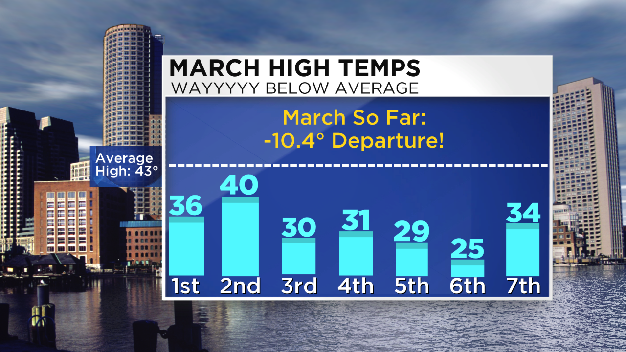 It's almost time for March Madness meaning college hoops and weather! I am looking forward to filling out the brackets but I am not sure I am looking forward to more snow. I enjoy snow in December, January and February but now it's time to move on and the temperature definitely did that today. After Boston's 109 consecutive hours of subfreezing weather this week, regional temperatures took a quantum leap to the 50s today. Anybody got spring fever? Boston's 2:30 pm max of 55 degrees was not close to the record of 68 set just two years ago when we were experiencing an extraordinary winter of incredible warmth and virtually no snow. Contrast that with the below average temperatures of the last 4 months. In fact, the mean temperature for the first 7 days of March 2014 is an astonishing 10.4 degrees below average! That is insane and we're all paying for it in our heating bills! Was today an aberration? As this month progresses, the sun will be strengthening so there should be more modification of the masses of cold air attacks from Canada. I am expecting more ups and downs in the temperature department. That starts now because tomorrow's highs will be back below average by about 8 degrees with highs in the middle 30s. By Tuesday, another surge of warmth will result in 50-55 degrees again. Unfortunately, that will be just another tease because it is destined to near 30 degrees for highs on Thursday and Friday followed by a warmup to 50 next Saturday. How's that for a roller coaster ride?
 Time to talk storms. The first disturbance and weather boundary will arrive predawn Monday. Most of the snow will fall mainly during portions of the morning commute. Expect a dusting up to an inch or so many areas. With the boundary draped across the region, a second impulse could release another dose of light snow mainly across northern New England Monday evening. As this is unfolding on Monday, a parcel of energy will be crossing the Rockies and delivering snow there as it presses toward the Plains. As it shifts into the Tennessee Valley, it will commence organization and intensification and tap Gulf of Mexico moisture. On Wednesday, the storm center will arrive over VA and its shield of rain, ice and snow will expand northeastward into New England. As always, the precise storm path will determine the main type of precipitation for various areas. Presently, it is too early to be confident of that crucial track but latest indications point to a potential significant snowfall across northern New England into portions of northern and northwestern MA. Areas near and farther south of the MA Pike are more vulnerable for rain or a mix and that may extend into the coastal plain of northeastern MA. As the storm center passes near or just south of Cape Cod Thursday morning, colder air circulating around the system will pull snow back into the Boston area with a bit of back-end light snow over southeastern MA. A path farther south or north will create a very different forecast for the region. In any event, as the storm exits toward Nova Scotia, gusty cold winds will chill the area into Friday.
For those who want to ski downhill/x-county or snowboard, snowshoe or snowmobile, conditions remain mighty fine with primary surfaces of machine-groomed packed powder and loose granular. You'll be very pleased almost everywhere. Many of the steep glades and shoots need a good dumping of snow and that may happen later Wednesday and Thursday. Hopefully, the storm track will not shift southward taking the snow with it. With skier traffic, some icy and hardpack patches may be exposed on steeper slopes. Other than that, have a happy and safe time on the trails and please be courteous and stay in control.