Frozen Lakes & Return of El Nino
Find Eric Fisher on Twitter and Facebook
We all know it's been cold. I actually have been cringing each time I receive a weather toss from Lisa or Jonathan, knowing that only a few people really want to hear what I'm dishing out. More below average temperatures, more chances for snow, blah blah winter in March. Well rest assured, it's been much worse to our west! While we had a fairly 'middle of the road' winter in Boston in terms of temperature and snow, records have been falling across the Midwest. One of those that's most stunning has to do with the ice on the Great Lakes.
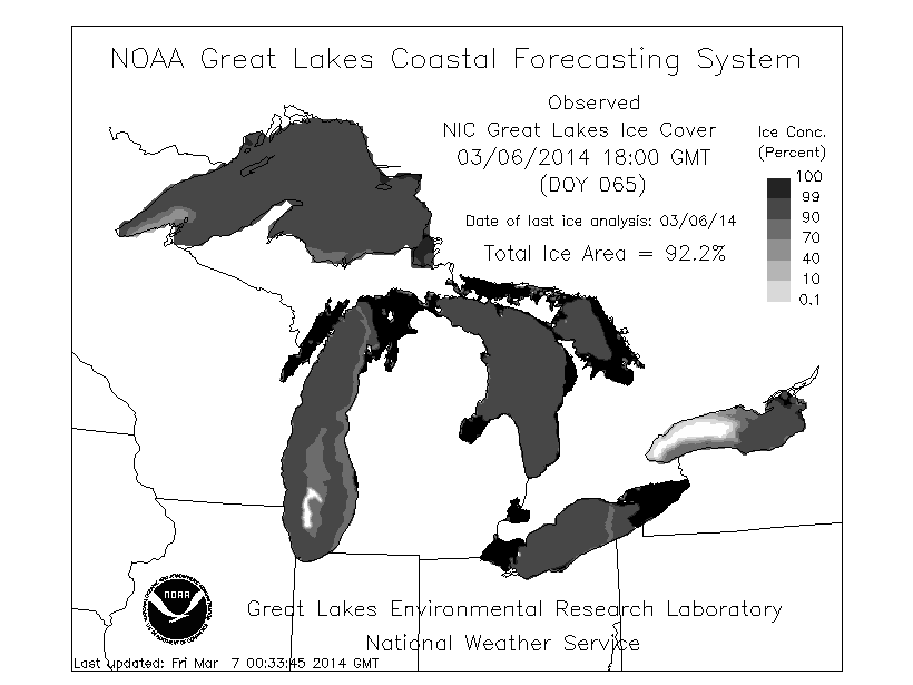
Source: GLERL
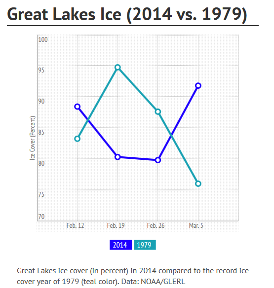
As of Thursday's update, the Great Lakes, as an entire system, are 92.2% covered in ice. A remarkable number, considering the past several winters have seen coverage hover in the mere 40-50% range! All that exposed water has been an issue for many years now, because the exposed lakes endure higher levels of evaporation through the winter. Plus, as you can imagine, less ice means warmer temps. That too can help increase evaporation rates. That combo has led to falling water levels to the point of concern. An ice covered winter is actually a good thing in that regard, stopping the flow of evaporation.
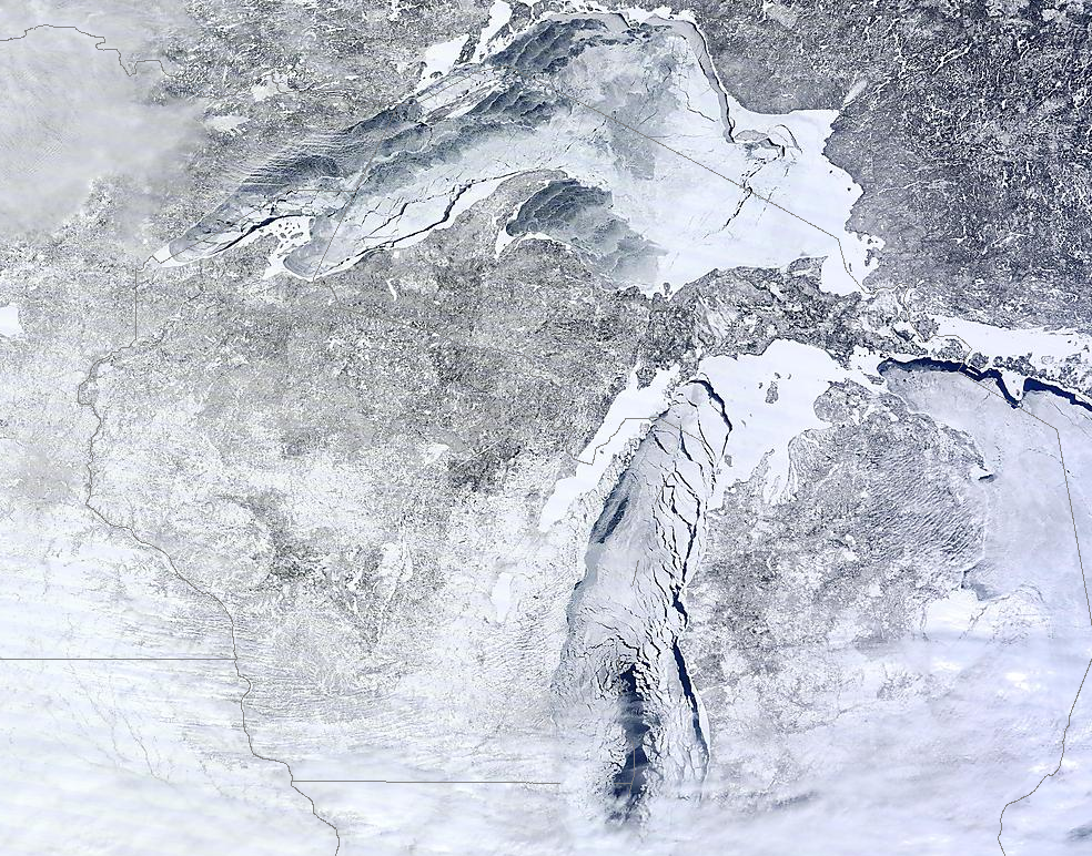
MODIS Terra pass over parts of the lakes on Wednesday, March 5th. Source: NOAA
So where does this year stand? Well records for the Great Lakes don't go back that far, only to 1973. And we all know that at one point during Ice Ages that the lakes were covered (as well as a much greater swath of the U.S.!). What we can say is that the ice cover now is the greatest in 35 years, and is approaching the 'ALL-TIME' record set in 1979 of 94.7% coverage. We can probably infer that the coverage wasn't greater at many other points during the past 50 years or so. Beyond that there's considerable uncertainty.
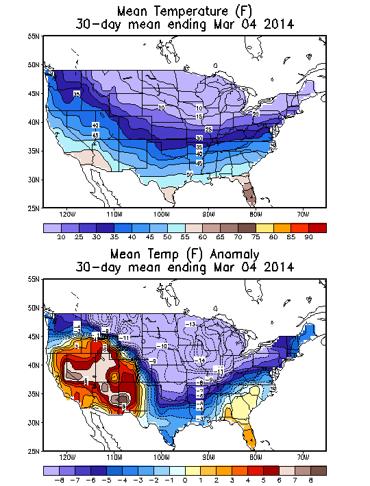
Extreme cold? Yep, all over the Midwest over the past 30 days. Source: Climate Prediction Center
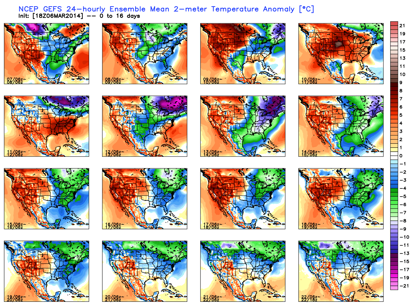
GFS ensemble mean says much more cold to come for the Great Lakes and Northeast regions. Source: WeatherBell
Superior, Huron, Michigan, and Erie are all at least 92% covered in ice. The one main holdout is Lake Ontario, which is deeper and relatively speaking is in a milder spot compared to the others. It stands at 56% as of Thursday the 6th. The forecast ahead is for more cold, but with a few mild spells. This time of year the ice can become much more volatile, with lots of swings between ice growth and decline on a short time scale. Just a week ago the total coverage was back in the 60% range! So we'll see if it can jump up to the record. In any case, the most rare part of all here is the fact that this peak is taking place in March. Typically you'd expect it in February. To have coverage over 90% this time in the season is not something that happens very often (indeed never in that 4-decade run of records). And with so much cold still to go the lakes will probably still feature very high ice coverage all the way until the end of the month.
For more excellent satellite imagery check out this blog from CIMSS: Great Lakes Ice in Imagery
The Return of El Nino?
It's a bit clunky (typical NOAA sometimes), but today the ENSO forecast status was updated to an 'El Nino Watch'. You can read all about it right here. So what does that mean? Well NOAA believe that there is a roughly 50% chance that El Nino could return by this summer, with an even higher probability heading toward the fall. It's not a screaming endorsement, but it's an enhanced risk leading into the 2nd half of this year. This would be the first El Nino phase of ENSO for about 4 years.
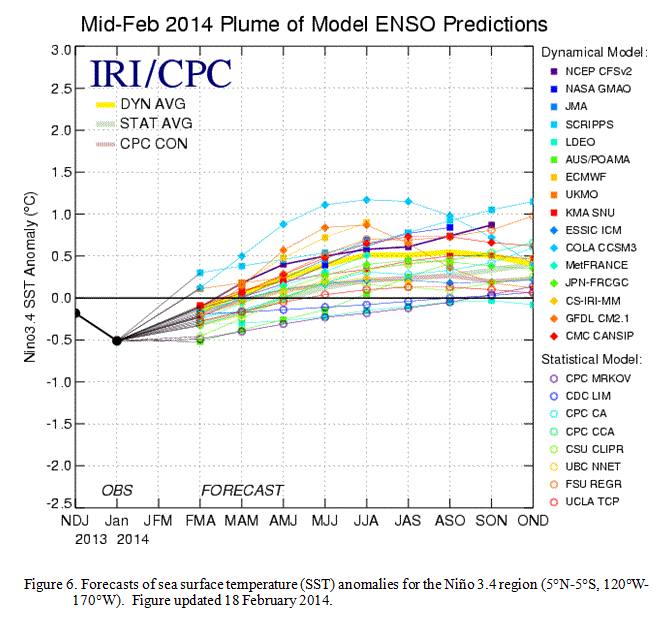
The bulletin from NOAA states that "sea surface temperature anomalies have recently increased near the International Date Line" as well as "in the central and east-central equatorial Pacific," and that "many dynamical models predict El Niño to develop during the summer or fall."
Mike Halpert, deputy director of the Climate Prediction Center, explained what the El Nino Watch actually means a little further. According to Halpert, "A watch simply means that conditions across the tropical Pacific are favorable for the development of El Niño during the next, roughly, three to six months."
What does that all mean? Well here's a general idea of what impact ENSO can bring to the U.S. in the summer.


Specifically here in MA, here are some of the details that go along with El Nino events. I pick this up in the fall to early winter, because the summer impact is rarely very significant in this part of the country. Or perhaps more accurately, it's hard to decipher much signal from the noise.


One thing that DOES seem to have a significantly strong correlation when it comes to El Nino is Atlantic Hurricane Season. Typically, El Nino produces strong winds across the Atlantic, increasing overall wind shear and decreasing the number of developing tropical systems. That being said, there have been El Nino years, like 1992, in which not many storms form but only one is needed for a devastating event. That one in 1992, of course, was Hurricane Andrew. That speaks to our usual tone on hurricane season. It doesn't really matter whether you have many storms or very few. What matters is where they track, and how strong they are. If you only had 3 hurricanes all season but they all plowed into populated areas, that's a season you wouldn't soon forget.