Cold Times with Snowy Nickels & Dimes
Find Eric Fisher on Twitter and Facebook
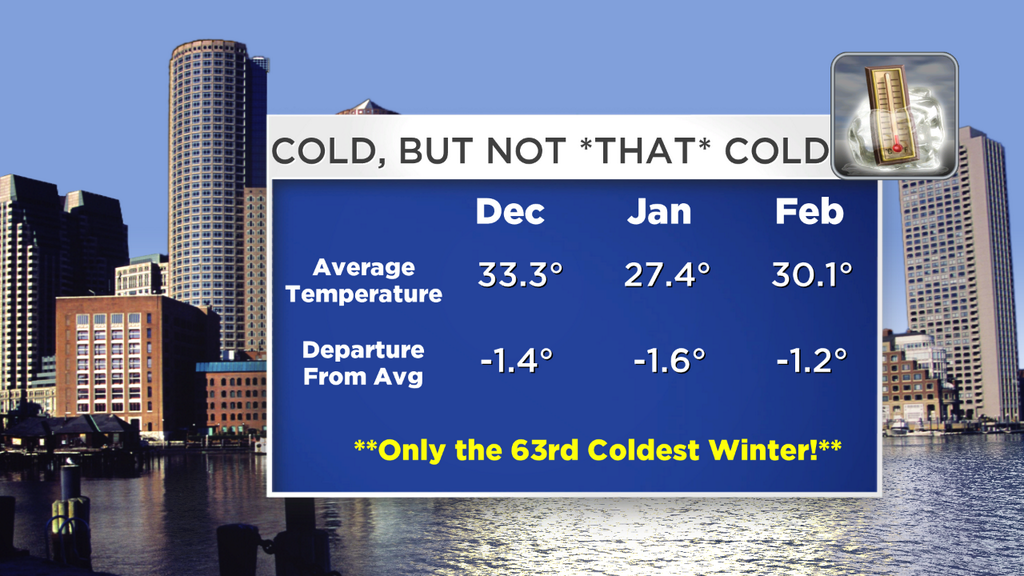
For sure, a few of us are tiring of the cold this winter. But interestingly enough, the few mild days have been so warm that they've really helped pull up the averages. Here's were we stand so far through Meteorological Winter (December, January, and February) and all told it's not very impressive. According to NWS Taunton, it's only our 63rd coldest winter on record! We'll drop into the 50s with all the cold this week, but still pretty middle of the road. However, each month as a whole has had an average temperature below normal, and it's the first time that's happened since the winter of 2002/03 (it barely made the cut then, with December just 0.1º below average).
The above graphic from NWS Taunton shows the coldest winters around Southern New England. It's interesting though that the Top 5 in Boston all occurred before the official climate site was at Logan. The observations moved there in 1936, and of course being on the water can alter the temperatures a little bit (in some cases drastically) compared to just a couple miles inland. Before they were at Logan they were taken inside the city...one location near Milk Street and at a different time at the Post Office. Just some wintry food for thought!
In any case, there's nothing but cold ahead in our weather crystal ball. I'd wager that the majority of New England will stay below 32º, day and night, for the next 2 weeks straight. In particular, the majority of of New Hampshire, Vermont, and Maine. A few towns in Massachusetts may be able to accomplish that feat too, no easy task in March! So our lakes and ponds will not be opening up much before St. Patrick's Day, snowmobile trails should stay pretty white, and maple syrup will not be in a rush to run this year. Let's hope that when it does warm up, it does so gradually so we get a good supply of syrup, because that is one thing our house is never without.
A few snow events on the horizon - so here are the details. A weak wave brings clouds and scattered snow showers on Wednesday. Not a big deal, with a coating to 2" expected. With temperatures mainly in the 20s it should have no issues sticking. But at least the wind won't be as bad as it has been the last couple of days.
On Thursday and Arctic Front will cross, and it looks fairly potent. There should be a good batch of squalls and snow showers along it, which will come through during the afternoon. We'll have to keep a close eye on this one as any burst of heavy snow in the vicinity of commute time can bring all sorts of headaches.
Behind that front is more brutally cold air. No snow in the forecast Friday, but it's the coldest day of the week with highs not leaving the 10s for higher elevations and low 20s elsewhere. It's not quite record breaking, but it's close to the 19º record 'low max' for the date, set over 130 years ago. And Friday night is the coldest night of the week, with many towns dipping subzero and the rest generally in the single digits. Stock up on red wine for your Friday night plans!
More flurries will likely be in the air on Saturday, but no big deal for those traveling or heading out and about. On Sunday a boundary will start to set up shop across the region, and areas of light snow are looking like a pretty good bet at this point. We won't be into the meat and potatoes of a storm, but we'll have to monitor the snow chances here to see if they'll have a significant impact on travel and plans.
The next 'big' storm potential comes on Monday, but the details are still fuzzy. It appears a juicy storm will be forming in the Deep South along a boundary of more frigid Arctic air and warm Gulf of Mexico air. A warm front will extend into New England from this, and moisture will focus along it. This one won't be a big Nor'easter or coastal event, but more of an overrunning setup. That means mild/moist air flowing over the top of cold air at the surface, forcing it to rise, condense, and voila, snow!
The main question marks for this one are 1) where does the boundary set up and 2) how much moisture are we talkin? Those are the details we'll be working out as we get closer. So don't go canceling any plans yet, but be wary that we may be shoveling quite a bit again come the start of next week. On March 3rd no less! Behind this potential snow is more cold air, which looks like it'll be around for all of next week too.