Next! Blizzard Conditions This Weekend
Find Eric Fisher on Twitter and Facebook
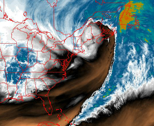
As stunning as a mature, wrapped up cyclone can get. This image via NOAA Friday afternoon.
Snow lovers? Heaven. Winter haters? Booking tickets to Florida. In the middle? Probably getting a little weary. So far it's been a fairly memorable season and it's far from over. In a rare sequence of events, two storms will be 'bombing out' within 48-60 hours of each other just off of the New England coast. Number one was quite a sight. As advertised, a kitchen-sinker with over a foot of snow for some, thunderstorms, thundersleet, freezing rain, localized flooding, and over 2" of rain for some. This next one, while a little more straight-forward, will still bring significant impact to the area.
The Setup:
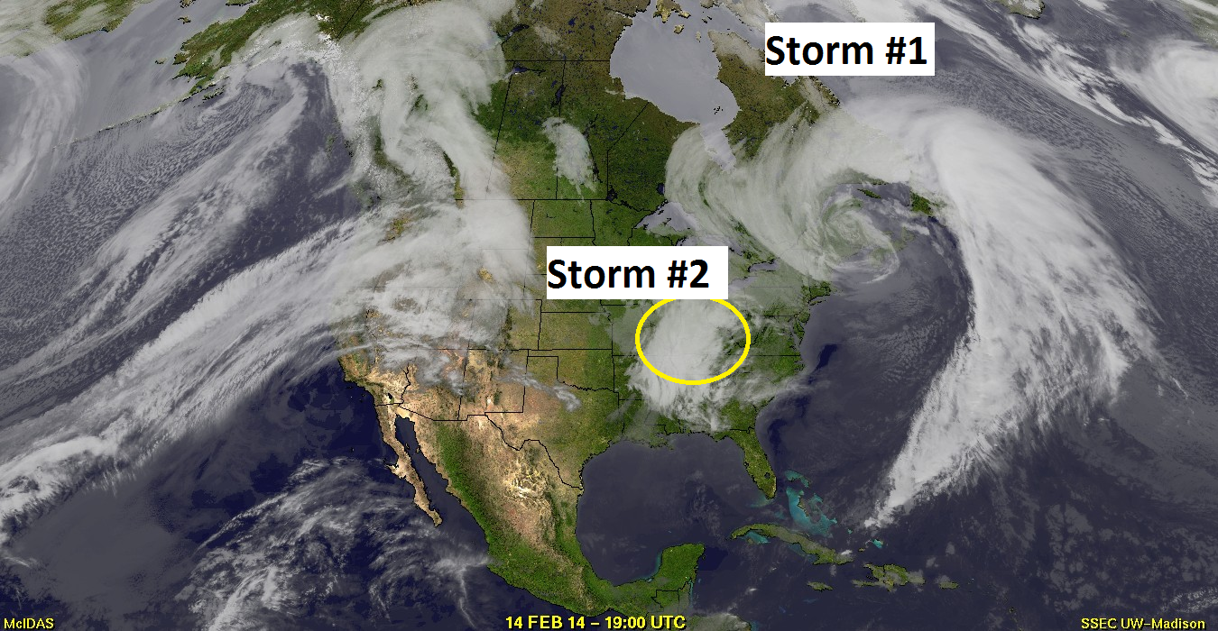
Pretty spectacular image showing storm #1 all wrapped up and storm #2 in its infancy over the Ohio Valley. Source: SSEC
The weekend storm looks pretty meager compared to the sprawling power of the one we just went through. Be that as it may, it will undergo an extremely rapid change over the next 36 hours. This little guy will quickly head to the Mid-Atlantic coast, head north, and become a coastal 'bomb.' In essence, it will see its minimum pressure drop from about 1004mb to 970mb by Sunday morning. Pressure falls when air above the system is 'diverging' or basically heading out laterally. This causes air to rush into the 'hole' left behind and fill the column back up. But rising air = clouds and precipitation, thus a storm is born!
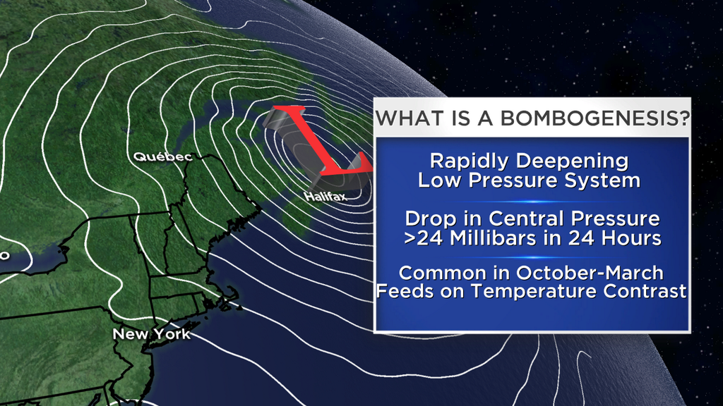
Weather word of the week seems to be 'Bombogenesis'
The mid-level support for this storm is a vigorous little vort-max which will slide up across our southeastern waters and force the trough to go 'negative tilt.' We Meteorologists see negatively tilted troughs, and know trouble is brewing. This one definitely looks close enough to bring plenty of snow and wind to the region Saturday night.
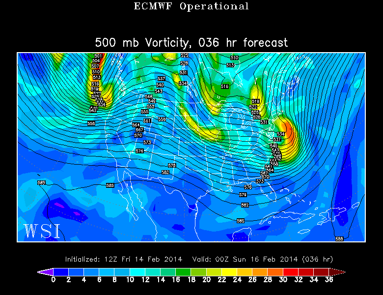
Source: WSI Energycast
Timing:
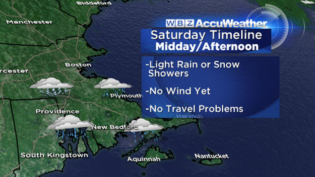
Alright Saturday is a big day with lots of folks having plans and heading out for a post-Valentine's Day dinner. If your plans are in the morning or midday hours, then you're fine. But as we head into the afternoon, areas of light rain/snow will develop. O.K. to deal with, but starting to get slick.
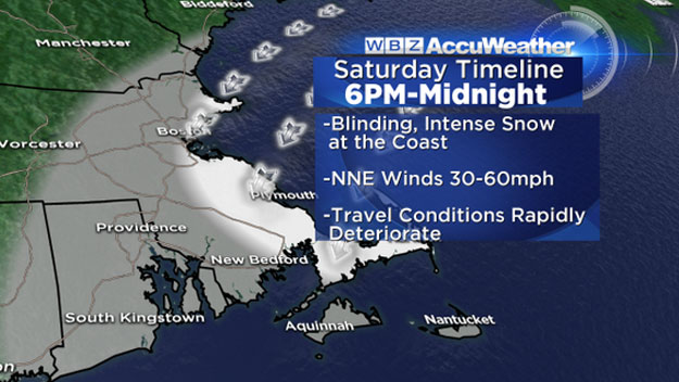
The tricky part of this forecast is that everything will happen very explosively, with a small window of VERY high impact weather. Don't be caught off guard! Once we head past 4pm, snow should increase in intensity and as we continue into the evening spots that start out as rain will quickly go to big wet snowflakes. So for dinner time and into the evening, travel will become MUCH more hazardous. Rates of 1-2" an hour will develop, especially east of I-495. As we say on Thursday, plows can't keep up with that.
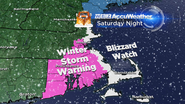
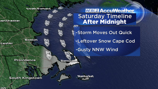
The height of this storm looks to be in the 6pm-midnight time frame. Once we head past 10pm, most of that snow will all be across SE Mass (South Shore, Cape Cod, Islands). Some snow will still likely be lashing Cape Ann, too. Overnight will be wild across the Cape & Islands with whiteout conditions, whipping winds, drifting snow. Quite the scene! Absolutely not a night to be on the roads, so grab a bottle of wine and some firewood and call it a romantic evening at home.
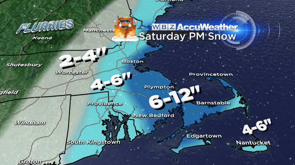
Snow Totals:
The dreaded snow total map. I am extremely happy with our forecast for the last storm and hope we can keep that going, but there are definitely some wildcards in this forecast. The GFS is a model with much higher precipitation and a much farther west track than the others. If that happens, we won't have many happy viewers. It would bring more significant snow farther west into Worcester County. I'm sticking with a solution closer to the ECMWF, mostly because I feel it's doing a better job with the upper-air pattern. This brings 6-12" of snow into Boston, much of coastal MA, and the Cape/Islands. Expecting up to a half foot in MetroWest, and much lower totals in Worcester County (a very manageable storm for central/western MA and should not be too disruptive to plans).
Ocean enhancement isn't out of the question, but the differential between ocean temps and 850mb temps doesn't look quite large enough to really play a big part. Just good old fashioned mesoscale banding! These very heavy snow rates should help bring the totals up on the Cape & Islands where you start as rain.
Wind:
As this low explosively deepens, the winds will get wild. Gusts over 50mph are likely, and perhaps topping 60mph on the Cape/Islands Saturday night. So that snow won't be coming down in a nice, gentle manner. We're talking horizontal snow, blowing and drifting, and very low visibility less than 1/4 mile. This is why a Blizzard Watch is up. Again, the moral of the story is very poor travel conditions Saturday evening/night. There may also be a few sct'd power outages because of the wind. The gusts will stay strong throughout the night and through all of Sunday as well. So this won't be too much of a fun storm to dig out of. Highs will stay in the 20s but wind chill values will be in the single digits on Sunday.
What's Next?
Not much rest for the weary. Another storm is moving in Monday night/Tuesday. The models look shifty to me for this one, and it could end up more significant than they suggest. The main low tracks through the Great Lakes, but we may see some secondary development near the coast. So for now, it looks like more snow, but also could have ice and rain all mixed in again. So more mess ahead!
We DO see a warming trend Thursday through the weekend. It won't exactly be Arizona, with quite a bit of cloud cover and damp weather to go along with those temps. But hey, at least it's a break. The 40s (50s?) will feel tropical after this recent run. I wish I could say it will last, but it will not. Most indications are for a return of brutal cold after next weekend. March in like a lion? Looks like it.


