Frosty February Continues
Find Eric Fisher on Twitter and Facebook
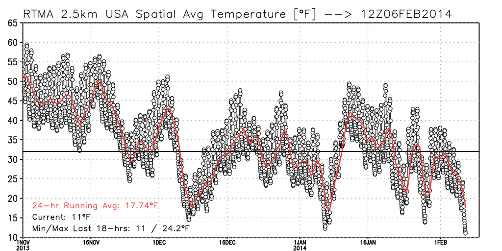
December was colder than average. January was colder than average. And the stretch laid out ahead of us should help to put February back on the path to some cold hard numbers after a mild first couple of days. I thought the cartoon above was pretty appropriate for how many Americans have been feeling over these past few months. In fact, this morning was the coldest morning for CONUS (Lower 48) this winter! Yes, even colder than the 'polar vortex' event in January or the major early Arctic blast in December. The biggest difference? The West Coast was in on the action this morning. For earlier outbreaks the west was under a bubble of record-shattering warmth. But no go this time around. The average temp for CONUS fell below 11º for a time, with ~1/3 of the Nation below 0º at 7a ET!
Source: WeatherBell and @RyanMaue
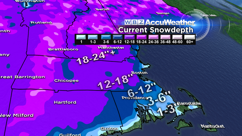
Believe it or not, we've been quite lucky here in Southern New England. The truly brutal cold has generally missed us to the west this winter. The Midwest in particular has just been crushed with consistently well below-average temperatures with little change in sight for the next couple of weeks. If anything, the long-wave trough that, for the past few days, has retrograded a bit to the west will shift back to where it spent much of January. While I don't see anything *major* in terms of cold here, I don't see a whole lot of warming potential either. So those who live winter sports will be in heaven with all this new snow to play in! Ski conditions look outstanding all around New England, probably the best weekend of the year to hit the slopes. Plenty for snowshoeing and cross-country too. Plus with so much cold air, the lakes, particularly in northern New England, have a nice thick sheet of ice on top.
Tonight any bit of melting from the daylight hours (more of that light each day, thankfully!) will rapidly freeze right back up. A cold winter's night, with 0s and 10s and a touch of westerly wind. Some areas, with deep snowpack and calming winds, should go subzero for a time. The best shot a subzero temps will be across Central MA and up into the valleys of southern NH. So watch that first step out the door...another icy start to the day. The finally Friday forecast looks a lot like Thursday's. Same temps (20s to low 30s) and lots of sunshine. A westerly breeze will add a bit of wind chill to the equation. Otherwise no major issues if you're traveling around or out of town.
The weekend looks interesting, but in general rather quiet. One area of low pressure swings through the Great Lakes on Saturday and brings some snowfall to places closing in on their snowiest winter's ever recorded (like Chicago, currently in 4th!). Another wave of low pressure heads out of the Gulf Coast states and out to sea. A few models suggest this will pass close enough to be interesting for our South Coast and Islands, but should mainly be a miss. It'll throw some high cloudiness over the region on Saturday but that should be about it. Just something to keep a wary eye on.
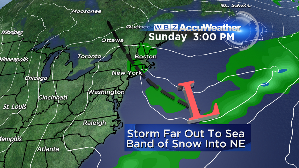
Another wave of low pressure follows that one out to sea on Sunday. This is the energy that the models have had such a tough time getting a good bead on over the past couple weeks. There have been all sorts of solutions, but in general the trend has been for a low-impact event. A trough (looks NOR-LUN-esque in some of the models) should reach back toward the Great Lakes low and help provide some lift. So bottom line is that we should see lots of clouds and some areas of light snow around on Sunday, but it does not look to be a significant storm. I can't completely write it off 3 days out, but that's where we stand tonight.
Some snow showers may linger into Monday before another blast of cold air filters down behind that departing maritime storm. The start of next week looks very chilly before the next piece of energy swings down through the south and tries to come up the coast. This is our next chance for significant snow, arriving late Wednesday into Thursday. Still 7 days out so plenty of time to watch.