Goodbye, January! Onward to a Mild Weekend
Find Eric Fisher on Twitter and Facebook
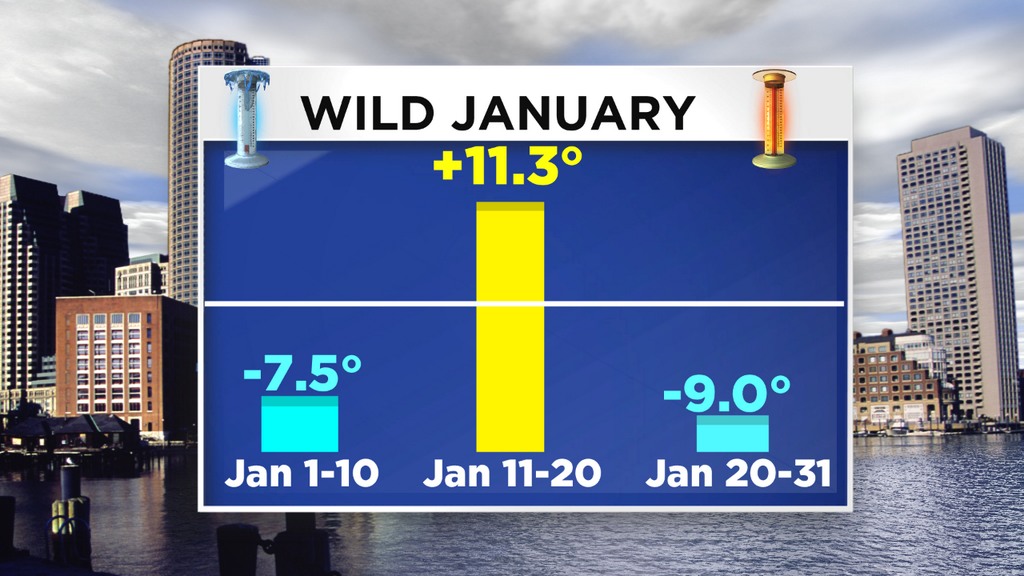
Goodbye January, don't let the door hit ya on the way out. The first month of the year can be a difficult one to navigate. Short amounts of daylight, some bitter cold, and the always lurking snow potential. We got a little of everything during January of 2014. Below are a couple graphics that are specific to Boston but hold for many towns in the area. The month was bookmarked by some very cold air, but overall evened out due to a big 'thaw' right smack dab in the middle. Shows you just what 'average' is - the middle of extremes!
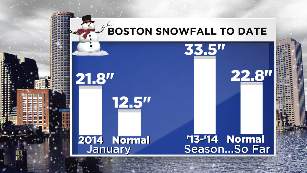
Snowfall is well ahead of both the January pace and the year-to-date pace in Boston, and again this holds for most of the area. It was a banner month for Cape Cod and the Islands, which are keeping pace with not just Boston but much of Worcester/Middlesex Counties and the North Shore! The combo of some odd storms has brought a somewhat even distribution of snowfall thus far.
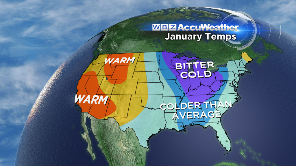
Around the country, there was a HUGE split between those living in an absolutely frigid climate and those basking in warmth. The core of the coldest air continuously plowed through the Upper Midwest, Ohio Valley, and Deep South. Towns like Indianapolis saw their coldest January in 35 years. Great Lakes ice coverage is at its greatest extent in over 2 decades. I haven't seen any monthly records set for cold (via NCDC), but there were a handful of all-time record low max temperatures. The map below, from Climate Central, shows the distribution of record highs vs record low maxes (a record low max is the coldest 'high' temperature on record, if that makes any sense).
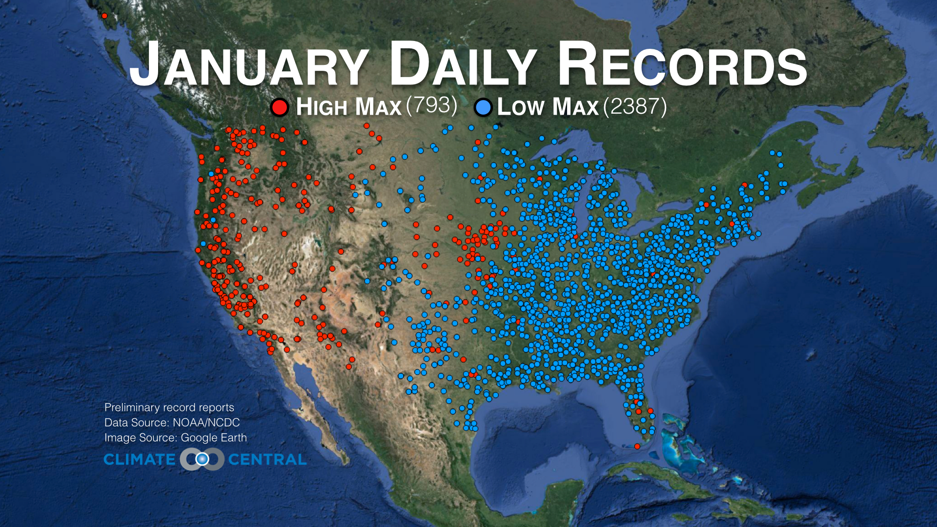
Source: Climate Central
From the warm side of the spectrum, there were nearly 4 dozen all-time highs for the month of January across the west. In general, the magnitude of the heat was larger than the magnitude of the cold...but the cold was more widespread. Alaska did particularly well in January - at times being much warmer than wide expanses of the Deep South! The warm weather was also very dry weather for much of the west. 90% of California is in 'Severe' or worse drought, as categorized by the U.S. Drought Monitor. Sierra snowpack, even with a storm finally hitting over the past 48 hours, is near all-time lows for this point in the season. Many lakes and reservoirs are drying up, and so they need a much more active end to their wet season if they're to avoid a rampant wildfire season and water restrictions throughout the summer.
So what does February hold for us? Well the first couple of days are going to be pretty easy to take. A quasi-stationary frontal boundary will be sticking around for most of the weekend, keeping plenty of clouds in the forecast. That being said, there should be breaks where things really brighten up from time to time during Saturday. Sunday looks a little gloomier with more persistent clouds. For temperatures - no complaints. Highs in the 30s to low 40s on Saturday and 40s to near 50 on Sunday! If you're a runner and getting ready for the Boston Marathon, this is a GREAT weekend to get in your long run.
In terms of precipitation - not too much is expected. We may see a few flurries tonight and into tomorrow, mainly across the Berkshires, Worcester hills, and into southern NH/VT. A few more snow showers may graze our viewing area Saturday afternoon in those same locations. South of there little to nothing is in the forecast. Most of the action will be to the north on Saturday, so skiers are in luck! There should be some fresh snow, particularly northern VT, NY, and NH. Not a HUGE event, but at least some natural stuff to whiten up the landscape! You won't have to travel far north of the MA border to get into the snow. As milder air moves in Saturday night and into Sunday, some of that may change over to a mix or rain, especially for southern VT/NH. On Sunday a cold front will slowly push through the area and bring a few rain showers with it, but nothing major.
Same holds for the Superbowl - totally boring weather after much hoopla over the outdoor game. Highs in the upper 40s, falling into the 30s during the game, maybe a shower or two, and that's about it. NFL is getting a free pass on this decision! A few hundred miles to the west in Punxsutawney, Phil will be dragged out of his hidey-hole on Sunday morning to deliver his prognostication. It appears that, unless all the camera flashes going off provide the light, he should NOT see his shadow with plenty of clouds around. But we know how that goes! Seems he managed to spot a shadow, even when the weather says it's impossible. Ms. G here in Lincoln will be dealing with clouds from the same weather system, so my bet is a no-shadow event.
After the benign weekend, next week looks busy!
Storm #1 - A wave of low pressure that passes quickly south of New England on Monday. This should come close enough to make a swipe at, you guessed it, southeastern MA again. The best shot at some accumulating snow looks to be south of the Mass Pike (early wager: a possible 1-4"?). This one isn't as cold as the last, so we'd probably have a wetter snow than the big time fluff from the last go-around. It'll depart quickly late Monday afternoon/evening.
Storm #2 - This one looks like a real mess. It doesn't take a pure snowstorm track for us, at least that's how it looks right now. The 500mb pattern doesn't do much for me in terms of big snow. Most of the energy passes to our NW without too much rapid coastal development. Unlike the past few storms, this one has less cold air to work with. So as a big plume of moisture heads in, we'll probably end up with a mixed bag. Still 4.5 days out so plenty will change on this one, but for now it appears to be a high impact kitchen sinker for New England with a thump of early snow, perhaps an extended period of sleet/freezing rain, and even a change to rain for some locations. The best shot at 'pure snow', and again this is 4.5 days out, looks to be northern New Enlgand (ski country!). The energy which will be responsible for this one isn't even to the Pacific Coast yet, so we won't be able to really lock in until later this weekend.
Storm #3 - Most models pointing to more potential for the following weekend, particularly Sunday. Way too early for details on this, but just a sign of the very active pattern we're entering into right now. No need to run to the grocery store for supplies :-) But another one to watch in what is shaping up like a busy February (they often are).